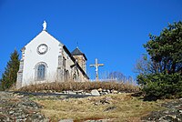
Saint-Genès-Champanelle
| Saint-Genès-Champanelle | ||
|---|---|---|

|
|
|
| region | Auvergne-Rhône-Alpes | |
| Department | Puy-de-Dôme | |
| Arrondissement | Clermont-Ferrand | |
| Canton | Beaumont | |
| Community association | Clermont Auvergne Métropole | |
| Coordinates | 45 ° 43 ' N , 3 ° 1' E | |
| height | 660-1,252 m | |
| surface | 51.58 km 2 | |
| Residents | 3,612 (January 1, 2017) | |
| Population density | 70 inhabitants / km 2 | |
| Post Code | 63122 | |
| INSEE code | 63345 | |
| Website | mairie.sgc.fr | |
 The village of Nadaillat with the Puy de Dôme in the background |
||
Saint-Genès-Champanelle is a French municipality with 3612 inhabitants (at January 1, 2017) in the department of Puy-de-Dôme in the region Auvergne Rhône-Alpes .
Location and geography
The municipality of Saint-Genès-Champanelle is located six kilometers southwest of the city of Clermont-Ferrand in the Volcans d'Auvergne Regional Nature Park in the Massif Central . The river Auzon has its source here . The community consists of the twelve districts
|
|
|
Population development
| year | 1962 | 1968 | 1975 | 1982 | 1990 | 1999 | 2007 |
| Residents | 1,213 | 1,416 | 1,592 | 2.008 | 2,465 | 2,688 | 3,044 |
Attractions
- Saint-Genès church
- Saint-Aubin Chapel
- Church of the Visitation of the Virgin Mary ( Église de la Visitation ) in the district of Beaune-le-Chaud
- Saint-Aubin church in the Manson district
- Saint-Nicolas church in the Laschamps district
- Church in the district of Nadaillat
particularities
The district of Laschamps is named after the Laschamp event , a brief reversal of the earth's magnetic field 41,000 years ago.
Town twinning
Saint-Genès-Champanelle maintains partnerships with the Ligurian Monterosso al Mare and since 1984 with the Bavarian Kallmünz .
Web links
Commons : Saint-Genès-Champanelle - Collection of images, videos and audio files


