
Saint-Saturnin (Puy-de-Dôme)
| Saint-Saturnin | ||
|---|---|---|
.svg)
|
|
|
| region | Auvergne-Rhône-Alpes | |
| Department | Puy-de-Dôme | |
| Arrondissement | Clermont-Ferrand | |
| Canton | Orcines | |
| Community association | Mond'Arverne Communauté | |
| Coordinates | 45 ° 40 ′ N , 3 ° 6 ′ E | |
| height | 460-890 m | |
| surface | 16.86 km 2 | |
| Residents | 1,172 (January 1, 2017) | |
| Population density | 70 inhabitants / km 2 | |
| Post Code | 63450 | |
| INSEE code | 63396 | |
_Village.jpg) Townscape with church and castle |
||

Saint-Saturnin is a French commune in the region of Auvergne Rhône-Alpes in the Puy-de-Dôme in the Arrondissement Clermont-Ferrand in the canton of Orcines .
geography
Saint-Saturnin is located about 20 km south of Clermont-Ferrand in the valley of the river Monne, which flows a little further down into the Veyre . The community of 16.86 square kilometers is located at 460 to 890 meters above sea level and has 1,172 inhabitants (as of January 1, 2017). The place is built on a basalt ridge , at the highest point of which is the church of St-Saturnin .
history
Saint-Saturnin was the seat of the lords of La Tour d'Auvergne , as evidenced by the strong fortified castle of Saint-Saturnin . With its narrow streets, the place has retained its medieval flair and therefore attracted many artists who settled here.
Attractions
- The Church of St-Saturnin is one of the six main churches of the Auvergnat Romanesque . It was in the first half of the 12th century in light arkose - sandstone and dark lava stone built and has with its octagonal bell tower, the French Revolution unscathed, so conservators other churches they could take as a model. The eastern part of the church forms an Auvergnatian pyramid in which the massif barlong is integrated. Inside there are capitals made of lava stone, a Romanesque statue of the Virgin Mary , a colored Pietà in the crypt and a head of Christ from the 15th century as well as wooden sculptures from the 18th century.
- Sainte-Madeleine Chapel , medieval, now an exhibition space, opposite the choir of the church
- the castle Saint-Saturnin , medieval fortification from the 13th century, with triple walling, battlements and defensive towers. The facade dates from the Renaissance period.
- Musée du peintre Madrassi , museum of the painter and illustrator Ludovic Lucien Madrassi (1881–1956)
- Parts of the city fortifications
- Nearby is the Randol Benedictine Abbey , built between 1970 and 1980, with a modern abbey church that is architecturally well worth seeing with stained glass windows

St-Saturnin Church

Chapel of Sainte-Madeleine

Village fountain
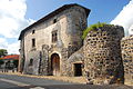
Defense works

Alley scene

Randol Benedictine Abbey


.jpg)
Web links
- Official website of the municipality (French)