Romagnat
| Romagnat | ||
|---|---|---|

|
|
|
| region | Auvergne-Rhône-Alpes | |
| Department | Puy-de-Dôme | |
| Arrondissement | Clermont-Ferrand | |
| Canton | Aubière | |
| Community association | Clermont Auvergne Métropole | |
| Coordinates | 45 ° 44 ′ N , 3 ° 6 ′ E | |
| height | 391-837 m | |
| surface | 16.84 km 2 | |
| Residents | 7,705 (January 1, 2017) | |
| Population density | 458 inhabitants / km 2 | |
| Post Code | 63540 | |
| INSEE code | 63307 | |
| Website | http://www.ville-romagnat.fr/ | |
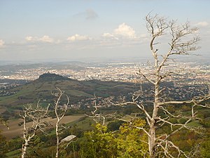
 View of Romagnat |
||
Romagnat is a French municipality with 7705 inhabitants (as of January 1 2017) in the department of Puy-de-Dôme in the region Auvergne Rhône-Alpes . Romagnat belongs to the Arrondissement of Clermont-Ferrand and is part of the canton of Aubière .
geography
Romagnat is south of Clermont-Ferrand . Romagnat is surrounded by Beaumont in the north, Aubière in the north-east, Pérignat-lès-Sarliève in the east, La Riche-Blanche in the south-east, Chanonat in the south, Saint-Genès-Champanelle in the west and south-west and Ceyrat in the west and north-west.
population
| year | 1962 | 1968 | 1975 | 1982 | 1990 | 1999 | 2006 | 2017 |
|---|---|---|---|---|---|---|---|---|
| Residents | 3,064 | 4,244 | 5,983 | 6,974 | 8,268 | 8,177 | 8,271 | 7,705 |
Attractions

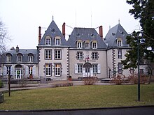
Town Hall ( Hôtel de ville )
- Rathaus (former castle)
- 11th century church in the hamlet of Opme, a historic monument since 1959
- Opme Castle from the 14th and 17th centuries, monument historique since 1916
Personalities
- Nathanaël Berthon (* 1989), racing car driver
Parish partnership
- Licciana Nardi , Province of Massa and Carrara (Tuscany), Italy
Web links
Commons : Romagnat - collection of images, videos and audio files
