
Pähl
| coat of arms | Germany map | |
|---|---|---|

|
Coordinates: 47 ° 54 ' N , 11 ° 11' E |
|
| Basic data | ||
| State : | Bavaria | |
| Administrative region : | Upper Bavaria | |
| County : | Weilheim-Schongau | |
| Height : | 590 m above sea level NHN | |
| Area : | 32.22 km 2 | |
| Residents: | 2446 (Dec. 31, 2019) | |
| Population density : | 76 inhabitants per km 2 | |
| Postal code : | 82396 | |
| Area code : | 08808 | |
| License plate : | WM, SOG | |
| Community key : | 09 1 90 138 | |
| LOCODE : | DE PAL | |
| Community structure: | 12 districts | |
| Address of the municipal administration: |
Kirchstrasse 7 82396 Pähl |
|
| Website : | ||
| Mayor : | Werner Grünbauer ( UBL ) | |
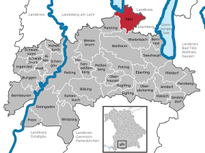
| Location of the municipality of Pähl in the Weilheim-Schongau district | ||
  |
||

Pähl is a municipality in the Weilheim-Schongau district in Upper Bavaria .
geography
Pähl is in the Oberland region .
The municipality has 12 districts (the type of settlement is indicated in brackets ):
|
|
There are the districts Fischen am Ammersee (with Vorderfischen, Mitterfischen and Aidenried), Pähl, Oberhirschberg and Kerschlach.
history
Until the church is planted
For the first time Pähl is in the time of Tassilos III. mentioned in a document. It speaks of Pouile or Poule , which in turn comes from the Latin words bovile, bos and bovis . Thus, the likely meaning leads to “cattle enclosure”.
The place soon developed into an important mansion with three castles, two of which are still preserved. The noble seat Pähl (high castle) belonged to the Andechs monastery . The Counts of Vieregg owned the Lower Castle with an open Hofmark (to the closed Hofmark Tutzing). Pähl belonged to the Rentamt München and to the district court Weilheim of the Electorate of Bavaria .
With the municipal edict of 1818 , the municipality of Pähl, which belonged to the Weilheim district court , was created.
Administrative community
The Pähl-Raisting administrative association that was established in 1978 was dissolved on January 1, 2007.
Incorporations
On May 1, 1978, the previously independent municipality of Fischen am Ammersee was incorporated.
Population development
Between 1988 and 2018 the community grew from 1,696 to 2,480 inhabitants or by 46.2%.
| year | 1840 | 1871 | 1900 | 1925 | 1939 | 1950 | 1961 | 1970 | 1987 | 1991 | 1995 | 2000 | 2005 | 2010 | 2015 |
| population | 725 | 745 | 830 | 1003 | 997 | 1666 | 1313 | 1333 | 1676 | 1913 | 1981 | 2289 | 2418 | 2394 | 2374 |

politics
mayor
On June 26th 2011 Werner Grünbauer (Independent Citizens List for Pähl and Fischen UBL) was elected 1st Mayor. His predecessors were Klaus Pfeiffer (CSU) from 2008 to 2011 and before that Rainer Kugler (CSU).
Municipal council
The municipal council has 14 seats. Since the 2014 local elections, the seats have been distributed as follows:
- Citizens for Pähl-Fischen: 4 seats
- CSU: 2 seats
- Village Movement eV: 2 seats
- Free voters Pähl e. V .: 3 seats
- Non-party voter community Fischen am Ammersee: 3 seats
coat of arms
The description of the coat of arms reads: Above a shield base in gold that is awakened by white and blue, an upright black bear armed in red.
The diamonds (Wecken) indicate the close relationship with the Wittelsbach rulers since the 13th century. The black bear is the coat of arms of the Lords of Berndorf, it can be found several times on the epitaphs in the church.


Culture and sights
- The Pähl high castle , built from 1883 to 1885 according to plans by the architect Albert Schmidt , is in an exceptional location high above the town.
- In the center of the village is the Lower Castle , a simple rectangular building from the 16th century.
- The copper museum in the Fischen am Ammersee district was opened in the summer of 2006.
- The baroque parish church of St. Laurentius , a church building that dates back to the middle of the 12th century
- The lovingly renovated Hofmarkmühle, probably more than 400 years old, is located within Pähl, the mill of which was only stopped in the 20th century. There is a restaurant and an antique shop in this building.
- The Pähler Gorge , which runs below the Hochschloss and the Hirschbergalm , is a protected geotope in the Nagelfluh rock
- The hamlet of Kerschlach with over 1200 years of history; Herrenschlösschen and St. Ulrich chapel from the former Kerschlach monastery of the Missionary Benedictine Sisters ; In the 1990s, an organically managed farm estate was created here under the leadership of Werner Mützel; Since 1997 Gut Kerschlach has been managed according to the EC ecological guidelines and the Naturland guidelines, and guided tours are offered regularly.
- The stagecoach line that regularly by the fleet of vehicles and Posthalterei Coaching in Bavaria in Kerschlach on the historic King Ludwig way to the castles of Neuschwanstein and Hohenschwangau wrong
- The Hirschberg lookout point with a comprehensive panoramic view of the Ammer valley and the Alpine chain
- The nature and bird sanctuary on the south bank of the Ammersee
- The annual Leonhardiritt in November
See also: List of architectural monuments in Pähl and List of ground monuments in Pähl
sports clubs
The largest sports club is TSV Pähl, in whose football youth Thomas Müller played for seven years . With around 600 members, the sports club mainly offers football, tennis, curling and table tennis. Depending on the season, youth athletics and ski gymnastics are also held.
The district of Fischen has its own small sports club, which was able to set up its own soccer team again in April 2006 after an interruption of more than ten years. Within three months, 51 young people between the ages of 16 and 28 joined this group. In the same year, a first team could be registered for play in the C-class.
There is also a small cycling club in Fischen. Team Optime was founded in 2007 and has an active road cycling team. The offer also includes other endurance sports such as running and cross-country skiing.
Right next to the Hochschloss Pähl is the 18-hole Golfclub Hohenpähl e. V.
Economy and Infrastructure
Economy including agriculture and forestry
In 1998 there were 16 employees in agriculture and forestry, 189 in manufacturing and 51 in trade and transport at the place of work. In other economic sectors there were 76 people. There were 631 employees at the place of residence subject to social security contributions. There were three companies in manufacturing (as well as mining and quarrying of stones and earth) and five in the construction industry. In addition, in 1999 there were 63 farms with an agriculturally used area of 1593 hectares. Of this, 284 hectares were arable land and 1306 hectares were permanent green space.
education
In 2012 the following institutions existed:
- Two day-care centers run by the Catholic Church with 100 places and 70 children
- Elementary school classes 1 to 4 in an independent school district with 85 students
Famous pepole
- Karl Haushofer (1869–1946), German geographer and university professor
- Franz Hart (1910–1996), German architect and professor at the Munich School
- Reiner Steinweg (* 1939), peace researcher
- Werner Diem (* 1944), German professor of Islamic studies
- Carola Regnier (1943–2011), German actress, diseuse and dancer
- Helmut Perlet (* 1947), German manager and chairman of the supervisory board of Allianz SE
- Thomas Müller (* 1989), German national soccer player, soccer world champion (2014)
- Felix Finkbeiner (* 1997), founder of the Plant-for-the-Planet Foundation
Web links
- Homepage of the municipality of Pähl
- Entry on the coat of arms of Pähl in the database of the House of Bavarian History
- Homepage with a detailed description of the Hofmarkmühle in Pähl
- Pähl: Official statistics of the LfStat (PDF; 1.24 MB)
Individual evidence
- ↑ "Data 2" sheet, Statistical Report A1200C 202041 Population of the municipalities, districts and administrative districts 1st quarter 2020 (population based on the 2011 census) ( help ).
- ^ Community Pähl in the local database of the Bavarian State Library Online . Bayerische Staatsbibliothek, accessed on September 4, 2019.
- ↑ a b Georg Paula , Stefanie Berg-Hobohm : District Weilheim-Schongau: Monuments in Bavaria. Volume 1, Lipp, Munich 2003, p. 199.
- ^ Josef Hemmerle : Hochschloß Pähl, history of an old Bavarian noble residence . Verlag Bayerische Heimatforschung, Munich-Pasing 1953, p. 9.
- ^ Federal Statistical Office (ed.): Historical municipality directory for the Federal Republic of Germany. Name, border and key number changes in municipalities, counties and administrative districts from May 27, 1970 to December 31, 1982 . W. Kohlhammer, Stuttgart / Mainz 1983, ISBN 3-17-003263-1 , p. 596 .
- ↑ Municipal statistics from Pähl , accessed on November 6, 2010
- ↑ http://www.gemeinde-paehl.de/index.php?id=0,31
- ↑ Archived copy ( Memento of the original from March 4, 2016 in the Internet Archive ) Info: The archive link was inserted automatically and has not yet been checked. Please check the original and archive link according to the instructions and then remove this notice.

Cities: Penzberg | Schongau | Weilheim in Upper Bavaria
Markets: Peißenberg | Peiting
Other municipalities: Altenstadt (Upper Bavaria) | Antdorf | Bernbeuren | Bernried am Starnberger See | Böbing | Burggen | Eberfing | Eglfing | Habach | Hohenfurch | Hohenpeissenberg | Huglfing | Iffeldorf | Ingenried | Oberhausen (near Peißenberg) | Obersöchering | Pähl | Polling (near Weilheim) | Prem | Raisting | Rottenbuch | Schwabbruck | Schwabsoien | Seeshaupt | Sindelsdorf | Steingaden | Wessobrunn | Wielenbach | Wildsteig