Southland District
|
Southland District Māori: Te Rohe Pōtae O Murihiku |
|
| Geographical location | |
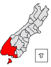
 Location of the Southland District |
|
| Photo from the Southland District | |
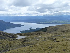
 View of the South Fiord (front left) and Lake Te Anau (rear left and right) from the Kepler Track |
|
| Local authority | |
| Country | New Zealand |
| island | South island |
| region | Southland |
| Local authority | District |
| Council | Southland District Council |
| Headquarters of the administration | Invercargill |
| mayor | Gary Tong |
| founding | 1989 |
| Post Code | 9583, 9586, 9600, 9610, 9620, 9630, 9635, 9672, 9679, 9681–9683, 9691, 9720, 9730, 9774–9779, 9781–9783, 9792–9794, 9816, 9822, 9825, 9831, 9871, 9872 9874-9877, 9883, 9884, 9892 |
| Telephone code | +64 (0) 3 |
| Website | www.southlanddc.govt.nz |
| presentation | |
| Motto |
People First ( people first ) |
| geography | |
| Region ISO | NZ-STL |
| Coordinates | 46 ° 25 ′ S , 168 ° 21 ′ E |
| Highest elevation | 2536 m |
| Lowest point | Height of sea level |
| surface | 29 552 km 2 |
| Residents | 29 613 (2013) |
| Population density | 1 inhabitant per km 2 |
| Statistical data | |
| Public revenue | NZ $ 57.9 million (2015) |
| Public expenditure | NZ $ 63.0 million (2015) |
| Number of households | 14th 886 (2013) |
| Ø income | NZ $ 33,900 (2013) |
| Māori population | 9.6% (2013) |
The Southland District is an administrative unit belonging to the Southland region in New Zealand . The district council, called the Southland District Council , is based in Invercargill City , as is the district administration.
geography
Geographical location
The Southland District has a total land area of 29,552 km², making it the largest district in the Southland region . At the census in 2013 the district had 29,613 inhabitants and thus had a population density of exactly 1.0 inhabitants per km².
The Southland District , with the exception of the Gore District and the city of Invercargill City , congruent with the borders of the region Southland . The district, to which Stewart Island also belongs, is bounded in the west by the coastline to the Tasman Sea and in the south by the coastline to the Foveaux Strait and the southern Pacific Ocean . Invercargill City also borders in the south . To the north of the Southland District are the Westland District , which is part of the West Coast Region , and the Queenstown-Lakes and Central Otago Districts , both of which are part of the Otago Region , as is the Clutha District , which is adjacent to the east. However, part of the central eastern border is formed by the Gore District , which belongs to the same region as the Southland District .
The west of the district is characterized by the alpine mountains of the New Zealand Alps , which run out to the coast in the southwest of the South Island. The north of the district, however, lies in the catchment area of the Eyre Mountains and the Garvie Mountains . To the southeast of the Gore District lies part of the Catlins , a low mountain range that the district shares with the adjacent Clutha District . The middle and eastern part of the district, on the other hand, is determined by wide plains such as the Southland Plains and the Waimea Plains .
The Southland District is home to two national parks, Fiordland National Park and part of Mount Aspiring National Park in the northwest. The largest rivers in the district are the two more than 200 km long Waiau River and Mataura River , both of which cross the district in a southerly direction and finally flow into the Foveaux Strait . The largest towns in the district include Winton with around 2100, Te Anau with around 1850 and Riverton with around 1450 inhabitants.
climate
Due to its location, the district is particularly exposed to the prevailing westerly and south-westerly winds. They bring cool and rainy weather. With around 8000 mm of rainfall over the year, the southwest is one of the rainiest areas on earth. Protected by the mountains in the west, the eastern areas of the district are comparatively dry with 800 to 1200 mm of precipitation. The average daytime temperatures in summer are between 13 ° C and 20 ° C, depending on the altitude, cooler in the mountains and warmer in the plains. In winter, the western and southwestern coastal regions are comparatively warm at 4 ° C to 7 ° C. In contrast, the average daytime temperatures in Germany are often in the single-digit minus range, around 0 to 2 ° C. The annual sunshine duration is very unevenly distributed in the district. While the southwest is consistently less than 1300 hours, the duration of sunshine increases to around 1800 hours the further you go north or east.
history
The Southland District was re-established as part of administrative reform in 1989 by merging the councils of Wallace County , Southland County , Stewart Island County and Winton Borough .
population
Population development
Of the 29,613 inhabitants of the district in 2013, 2,829 inhabitants were of Māori origin (9.6%). This means that 0.5% of the country's Māori population lived in the Southland District . The median income for the population in 2013 was NZ $ 33,900 compared to NZ $ 28,500 national average.
Origin and languages
When asked about ethnic group membership in the 2013 census, 89.8% said they were European, 10.0% said they had Māori roots, 0.8% came from the islands of the Pacific and 3.9% % came from Asia (multiple answers were possible). 11.5% of the population said they were born overseas. 1.6% of the population spoke Tagalog as the second most common language after English. The Māori language mastered only 10.8% of Māori .
politics
administration
The Southland District is again divided into five wards , the Mararoa Waimea Ward , the Waiau Aparima Ward and the Winton Wallacetown Ward with three Councilors each , the Waihopai Toetoes Ward with two and the Stewart Island Rakiura Ward with one Councilor . The twelve councilors together with the Mayor (Mayor) the district council (district council) and every three years to be re-elected.
Town twinning
The Southland District Council has two partnerships:
-
 Cinque Terre , Italy , a town twinning since 2009.
 -
 Wyong Shire , New South Wales , Australia partnered as a Friendly City .
Infrastructure
Road traffic
The Southland District is connected by the New Zealand State Highway 1 , which begins in Bluff on the south coast and connects Invercargill with Dunedin in the northeast. The State Highway 6 connects Invercargill to Queenstown in the north, passing through the center of the district. The northwest is connected to the State Highways 94 and 99 and the State Highways 90 , 93 , 96 and 98 provide cross connections within the district.
Rail transport
The South Island Main Trunk Railway connects Invercargill with Dunedin and crosses the district between Invercargill and Gore . Only goods are transported over the connection.
Air traffic
The airport to the west of Invercargill connects the district with all regional airports in the country.
Shipping
Mainly goods are transported via the natural harbor of Bluff , which is part of the urban area of Invercargill and through which the district is connected to the other ports of the country. Only the ferry connection to Stewart Island in the south is also used for passenger transport.
Web links
- Homepage . Southland District Council,accessed July 23, 2016.
Individual evidence
- ^ Postcode Boundaries - Southland District . (PDF 4.4 MB) New Zealand Post , accessed May 7, 2017 (English).
- ↑ a b c d e 2013 Census QuickStats about a place : Southland District - Population and dwellings . Statistics New Zealand , accessed July 23, 2016 .
- ↑ a b c d e f Southland District Council . In: Local Councils . Department of Internal Affairs , accessed July 23, 2016 .
- ↑ a b c Topo250 maps . Land Information New Zealand , accessed July 23, 2016 .
- ↑ National Parks . Department of Conservation , accessed July 16, 2016 .
- ↑ GR Macara : The Climate and Weather of Southland . In: NIWA Science and Technologies Series . 2nd Edition. Number 63 . National Institute of Water and Atmospheric Research , 2013, ISSN 1173-0382 , p. 6, 16, 24, 30 (English, Online PDF 2.9 MB [accessed on July 23, 2016]).
- ↑ a b Role of Council . Southland District Council , accessed July 23, 2016 .
- ↑ 2013 Census QuickStats about a place : Southland District - Cultural diversity . Statistics New Zealand , accessed July 23, 2016 .
- ↑ International Relationships . Southland District Council , accessed July 23, 2016 .
