
Red at the lake
| coat of arms | Germany map | |
|---|---|---|

|
Coordinates: 49 ° 15 ' N , 10 ° 1' E |
|
| Basic data | ||
| State : | Baden-Württemberg | |
| Administrative region : | Stuttgart | |
| County : | Schwäbisch Hall | |
| Height : | 419 m above sea level NHN | |
| Area : | 74.81 km 2 | |
| Residents: | 5388 (December 31, 2018) | |
| Population density : | 72 inhabitants per km 2 | |
| Postal code : | 74585 | |
| Area code : | 07955 | |
| License plate : | SHA, BK , CR | |
| Community key : | 08 1 27 071 | |
| LOCODE : | DE RO6 | |
| Address of the municipal administration: |
Raiffeisenstrasse 1 74585 Rot am See |
|
| Website : | ||
| Mayor : | Siegfried Gröner | |
| Location of the community Rot am See in the district of Schwäbisch Hall | ||
  |
||

Rot am See (previously written as "Roth am See") is a municipality in the Hohenlohe region, in the Schwäbisch Hall district in the Franconian north-east of Baden-Württemberg .
geography
Geographical location
Rot am See is located north of Crailsheim in the eastern part of the Hohenlohe Plain and is traversed by a section of the Jagst tributary Brettach .
Neighboring communities
The community borders in the north on Blaufelden , in the east on the Bavarian town of Rothenburg ob der Tauber and the communities Insingen , Wettringen and Schnelldorf (all districts of Ansbach ), in the south on Wallhausen and the town of Kirchberg an der Jagst and in the west on the town of Gerabronn .
Community structure
The municipality of Rot am See consists of the formerly independent municipalities of Beimbach, Brettheim, Hausen am Bach and Reubach, which were incorporated into Rot am See. The municipality of Rot am See includes 34 villages, hamlets, farms and houses.
- The former municipality of Beimbach includes the village of Beimbach, the hamlets of Heroldhausen, Kleinbrettheim, Lenkerstetten and Oberndorf, the Werdeck homestead and the Lauramühle and Rotmühle houses as well as the abandoned villages of Salzbrunnen and Werdeck Castle .
- The former community of Brettheim includes the village of Brettheim, the hamlets of Hegenau, Herbertshausen and Hilgartshausen and the Brettachmühle and Rohrturm farms.
- The village of Hausen am Bach, the hamlets of Buch and Hertershofen and the Klosterhof homestead belong to the former municipality of Hausen am Bach.
- The former municipality of Reubach includes the village of Reubach, the hamlets of Kleinansbach, Kühnhard, Reinsbürg and Weikersholz, and the Thomasmühle farmstead, as well as the abandoned villagesügelhof and Weiler bei Reinsbürg.
- The municipality of Rot am See in the territorial status of January 31, 1972 included the village of Rot am See, the hamlets of Bemberg, Musdorf, Niederwind and Oberwind, the municipality of Brettenfeld, the Seemühle farmstead and the houses Aumühle, Bartenmühle and Schwarzenmühle as well as the localities of Birkach, Eulenhof, Krettenbach and Rufach.
The remains of the Bebenburg castle are located near the hamlet of Bemberg .
Division of space
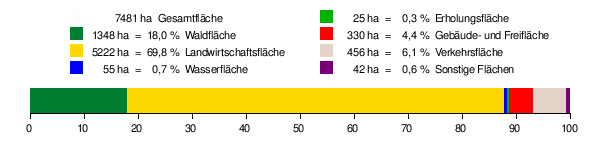
According to data from the State Statistical Office , as of 2014.
history
Rot was first mentioned in a document in 1139. During the time of the tribal duchies, the place belonged to the Duchy of Franconia . In the period from 1333 to 1345, the Seebach was dammed into a lake with the construction of a dam near the Seemühle. The place owes its name to this reservoir. The lake was drained again in 1757, however, the name stuck.
Rot am See was hit by the witch hunt in 1596 . Magdalena Ludwig got into a witch trial , but despite torture did not confess and was released.
In 1645 Rot became the capital of the Brandenburg-Ansbach office of Lobenhausen and was part of the Franconian Empire . After a short Bavarian interlude from 1806 to 1810, Red came to Württemberg . In the Kingdom of Württemberg the community belonged to the Oberamt Gerabronn . After its dissolution, it came to the Crailsheim district in 1938 and finally to the Schwäbisch Hall district in 1972 .
Incorporations
In the course of the municipal reform in Baden-Württemberg, four previously independent municipalities were incorporated into Rot am See: Reubach on February 1, 1972, Hausen am Bach on April 1, 1972, Brettheim on January 1, 1973 and Beimbach on January 1, 1974.
Districts

|

|

|

|
|---|---|---|---|
| Beimbach | Brettheim | Hausen by the brook | Reubach |
Beimbach
Beimbach was first mentioned in a document in 1383. It was Hohenlohe for a long time , then came to the Kingdom of Württemberg via Bavaria in 1810 . After the place fell to the municipality of Lenkerstetten in 1823 and five years later to Gerabronn , Beimbach only became an independent municipality in the Oberamt Gerabronn in 1850 .
Brettheim
Brettheim was first mentioned in a document as early as 1251. It was given as a Stauferlehen to the Lords of Brettheim . In the 15th century, sovereignty over the place passed to Rothenburg ob der Tauber . After brief membership of Bavaria, the place fell to the Kingdom of Württemberg in 1810, which assigned it to the Oberamt Gerabronn.
see also Brettheim Castle
Due to the decades of musical work of the pastors Hans-Gerhard and Elisabeth Hammer with the Brettheim children's choir , the place name became known nationwide.
In the last days of World War II , residents disarmed a squad of four Hitler Youths who wanted to defend the village against the approaching US troops. The Waffen-SS then set up a court martial . SS-Gruppenführer Max Simon hanged three citizens of Brettheim, the men of Brettheim , on April 10, 1945 . Mountaineers defended the village against US troops who launched artillery and air strikes. 17 residents were killed and 85 percent of Brettheim's houses were destroyed.
Hausen by the brook
With its first mention in 1212, Hausen is the longest known suburb of Rots after the main town. In the 14th century, Hausen came to Rothenburg ob der Tauber, where it was assigned to the Insingen office. Like the other suburbs, Hausen came to Württemberg via Bavaria at the beginning of the 19th century and there to the Oberamt Gerabronn. In April 1945 the place was badly damaged by the effects of the war.
Reubach
Reubach was first mentioned in 1329 as Reutbuch, which means something like clearing in the beech forest . Like Brettheim and Hausen, the place in the meantime fell to Rothenburg ob der Tauber and then came to the Württemberg Oberamt Gerabronn via Bavaria.
religion
Since the Reformation , Rot and its suburbs have been predominantly evangelical; there are five Protestant parishes and one Roman Catholic parish in the village.
politics
Administrative association
The community is the seat of the community administration association Brettach-Jagst to which besides Rot am See also the neighboring community Wallhausen and the neighboring town Kirchberg an der Jagst belong.
Municipal council
In addition to the mayor, the municipal council has 21 members. The 2014 election resulted in the following:
- General voter association / CDU 51.7% (+ 1.3%), 11 seats (- 1)
- Active & Open 48.3% (- 1.3%), 10 seats (± 0)
mayor
Siegfried Gröner, who has been in office since 2002, was confirmed in office in January 2010 with 97.93% of the votes and in 2018 with 91.25% of the votes.
coat of arms
Blazon: "Above a silver (white) corrugated shield foot on green ground in silver (white) three green poplars".
Partner communities
Rot am See maintains partnerships with Weyersheim in Alsace and Chatte in southern France .
Culture and sights
Museums
The Reubach local history museum is housed in the old village school of Reubach. The memorial site Die Männer von Brettheim in the town hall of Brettheim was set up to commemorate three Brettheim citizens who were hanged by the SS and the Wehrmacht in the final phase of the Second World War for disarming four Hitler Youths to prevent the destruction of the village by the Americans.
Buildings
During the construction of a community center in 1990, Rot am See's Erdstall was discovered.
Regular events
Brettheim hosts a cattle market twice a year, in March and December . In Beimbach there is the Bartholomämarkt annually in the second half of August and in Musdorf the Muswiese takes place annually in October , the oldest (since the 12th century) and largest fair in Hohenlohe. Since 1995 there have been amateur theater performances every July on the streets of Reubach, the Reubach Summer Theater, which has been supported by the association of the same name since 1998.
On the last weekend (Friday – Sunday) in July, the Rot am See riding and driving club organizes the Hohenlohe riding event with dressage and jumping tests and a jump & drive test on the Muswiese area around the riding facility in the Musdorf suburb, where, in addition to a jumping course, an automobile course has to be mastered on a VW Touareg . The tournament is classified as a horse performance show in the BAC category. The accompanying program includes live concerts, parties, morning pints with brass music and equestrian show evenings.
Economy and Infrastructure
traffic
Rot am See is connected to the railway network through the Rot am See station on the Crailsheim – Königshofen railway line. Trains run to Aschaffenburg and Crailsheim every hour. The federal highway 290 ( Tauberbischofsheim - Westhausen ) connects Rot am See with the national road network.
education
In the main town there is a community school for grades 1 to 10, the Brettheim district has its own elementary school. In Rot am See there are also two kindergartens run by the municipality.
Personalities
Sons and daughters of the church
- Magdalena Ludwig got into a witch trial around 1596 , but did not confess despite torture and was released.
- Wilhelm Friedrich Maier (1859–1931), Oberamtmann of Württemberg
- Friedrich Hanselmann (1895–1945), farmer and one of the men from Brettheim
- Leonhard Gackstatter (1881–1945), mayor and one of the men of Brettheim
- Leonhard Wolfmeyer (1903–1945), teacher and one of the men from Brettheim
- Fritz Stein (1879–1956), born in Hertershofen, theologian
- Leonhard Heißwolf (1880–1957), politician (SPD)
- Georg Trump (1896–1985), graphic artist and typographer
- Karl Östreicher (1931–1998), politician (CDU)
- Ernst Keitel (1939–2014), politician (CDU)
People who worked on site
- Max Simon (1899–1961), SS group leader and lieutenant general of the Waffen SS as well as war criminal ("Murderer of Brettheim")
- Friedrich Bullinger (* 1953), politician (FDP / DVP)
literature
- Jürgen Bertram : The Brettheim drama. A village story at the end of the Second World War . Fischer-Taschenbuch-Verlag, Frankfurt am Main 2005. ISBN 3-596-16534-2 .
- Johann Kaspar Bundschuh : Roth am See . In: Geographical Statistical-Topographical Lexicon of Franconia . tape 4 : Ni-R . Verlag der Stettinische Buchhandlung, Ulm 1801, DNB 790364301 , OCLC 833753101 , Sp. 603-604 ( digitized version ).
- Helmut Haberkamm , Annalena Weber: Small collection of Franconian villages . Cadolzburg : ars vivendi Verlag , 2018. ISBN 978-3-86913-990-6 (pages 196–205)
- Georg Paul Hönn : Beymbach . In: Lexicon Topographicum of the Franconian Craises . Johann Georg Lochner, Frankfurt and Leipzig 1747, p. 318 ( digitized version ).
- Gottfried Stieber: Mußdorff . In: Historical and topographical news from the Principality of Brandenburg-Onolzbach . Johann Jacob Enderes, Schwabach 1761, p. 597 ( digitized version ).
- Gottfried Stieber: Reubach . In: Historical and topographical news from the Principality of Brandenburg-Onolzbach . Johann Jacob Enderes, Schwabach 1761, p. 650-651 ( digitized version ).
- Gottfried Stieber: Roth am See . In: Historical and topographical news from the Principality of Brandenburg-Onolzbach . Johann Jacob Enderes, Schwabach 1761, p. 687-688 ( digitized version ).
- Gottfried Stieber: Werdeck . In: Historical and topographical news from the Principality of Brandenburg-Onolzbach . Johann Jacob Enderes, Schwabach 1761, p. 937-939 ( digitized version ).
Individual evidence
- ↑ State Statistical Office Baden-Württemberg - Population by nationality and gender on December 31, 2018 (CSV file) ( help on this ).
- ^ The state of Baden-Württemberg. Official description by district and municipality. Volume IV: Stuttgart district, Franconian and East Württemberg regional associations. Kohlhammer, Stuttgart 1980, ISBN 3-17-005708-1 . Pp. 506-513
- ↑ Area since 1996 according to actual use - State Statistical Office Baden-Württemberg. Retrieved January 24, 2020 .
- ↑ Traudl Kleefeld: Compilation of the witch trials found in the area of the Margraviate of Ansbach in: Hans Gräser, Traudl Kleefeld and Gernot Stepper: Witch persecution in the Margraviate of Brandenburg-Ansbach and in the rule of Sugenheim with sources from the official city of Crailsheim (Middle Franconian Studies, Volume 15 and publications on Local history and local history in Württembergisch Franconia, Volume 19) Ansbach 2001, pp. 424–433
- ^ Federal Statistical Office (ed.): Historical municipality directory for the Federal Republic of Germany. Name, border and key number changes in municipalities, counties and administrative districts from May 27, 1970 to December 31, 1982 . W. Kohlhammer, Stuttgart / Mainz 1983, ISBN 3-17-003263-1 , p. 447 f. and 467 .
- ^ Südwest Presse Online-Dienst GmbH: Church: Pastor Hans-Gerhard Hammer leaves the community. July 2, 2013, accessed January 24, 2020 .
- ↑ Wolf Stegemann : View to Brettheim I: In the last days of the war, SS henchmen had civilians executed . on Rothenburg under the swastika , accessed on December 29, 2014.
- ↑ Hausen am Bach (1,251 ha, 440 m above sea level). Rot am See mayor's office, accessed on January 24, 2020 .
- ↑ Reubach (1,300 ha, 466 m above sea level). Rot am See mayor's office, accessed on January 24, 2020 .
Web links
- Map of the municipality of Rot am See on: State Agency for the Environment Baden-Württemberg (LUBW) ( information )
- Map of the village of Rot am See on: Geoportal Baden-Württemberg ( information )
- DER SPIEGEL 24/1960
- DER SPIEGEL 32/1960
- HOHENLOHER TAGBLATT of May 8, 2013

Blaufelden | Braunsbach | Bühlertann | Bühlerzell | Crailsheim | Fichtenau | Fichtenberg | Frankenhardt | Gaildorf | Gerabronn | Ilshofen | Kirchberg an der Jagst | Kreßberg | Langenburg | Mainhardt | Michelbach an der Bilz | Michelfeld | Oberrot | Obersontheim | Rose garden | Red at the lake | Satteldorf | Schrozberg | Schwäbisch Hall | Stimpfach | Sulzbach-Laufen | Untermünkheim | Vellberg | Wallhausen | Wolpertshausen