
Otting
| coat of arms | Germany map | |
|---|---|---|
.svg)
|
Coordinates: 48 ° 52 ' N , 10 ° 48' E |
|
| Basic data | ||
| State : | Bavaria | |
| Administrative region : | Swabia | |
| County : | Danube Ries | |
| Management Community : | Wemding | |
| Height : | 487 m above sea level NHN | |
| Area : | 13.4 km 2 | |
| Residents: | 785 (Dec. 31, 2019) | |
| Population density : | 59 inhabitants per km 2 | |
| Postal code : | 86700 | |
| Area code : | 09092 | |
| License plate : | DON, Lower Austria | |
| Community key : | 09 7 79 198 | |
| Community structure: | 4 parts of the community | |
| Address of the municipal administration: |
Wolferstädter Str. 2 86700 Otting |
|
| Website : | ||
| Mayor : | Wolfgang Lechner (Free Voters) | |
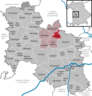
| Location of the municipality of Otting in the Donau-Ries district | ||
  |
||

Otting is a municipality in the Swabian district of Donau-Ries and a member of the Wemding administrative community .
geography
The Jura village is located in the Augsburg planning region between Wemding and Monheim .
The municipality has four officially named municipal parts (the type of settlement is given in brackets ):
- Dattenbrunn ( hamlet )
- Henthalhof ( wasteland )
- Otting ( parish village )
- Weilheimerbach (hamlet)
There is only the Otting district .
particularities
The "Pumper Cave"
The Otting Pumper Cave is a testament to a bygone era. In front of the cave, which is said to be about 240 meters long, there is dolomite scree. After a few turns there is a place with medium-sized stalactites. The cave has cistern-like depths in which water rushes. Behind the first cave, a second and third cave with an area of around 10 m² and four meters in height were discovered. A fourth and further cave can only be entered lying down.
Remnants of an old sacrificial site near the Pumper Cave give an indication of people who may have lived in the cave a long time ago, hunted in the area and worshiped their gods.
The suevite quarry
Otting has a geological feature, namely suevite . This volcanic rock came from a meteorite impact on the Jura when the Ries basin was formed .
In August 1970, the four astronauts Shepard , Mitchell , Engle and Cernan were in the suevite quarry Otting to deepen their knowledge of the moon rocks . In 1976, research drilling was carried out for the US space agency NASA . After the successful completion of the Apollo 14 company, it was confirmed that the geological structure of the debris field in the Fra-Mauro crater of the moon corresponds to that of the Rieskessel, which also includes the Ottingen quarry.
In May 1977 NASA had further geological investigations carried out in the suevite quarry. Under the direction of the American geologist Dr. Chao and the Freiburg geologist Dr. Hüttner, a new scientific model was created. Through a deep borehole, the primary rock of the Jura was found again at a depth of 58.29 meters. All the drill cores were packed in boxes and shipped to the US space research laboratory. As those involved explained at the time, it can be strongly assumed that further drilling would have led to hot, mineral-rich water, as the eruption about 14.8 million years ago created underground cavities. The former office building of the suevite quarry is still there. The powder house, in which explosives were stored, is still standing nearby.
The suevite quarry is now owned by Märker Zementwerk Harburg GmbH. The company extracts the suevite for the production of cement and suevite lime.
The Viereckschanze Alleho
A square hill from the Celtic times was found in the Alleho forest. The Celts were the inhabitants of the Ries area before the Romans came in 15 AD . In addition to found graves, tools, weapons and jewelry, such square entrenchments testify to them. These were probably temples or even dwellings that offered protection through walls and moats.
From the only gate a straight path led to the middle of the hill. The sanctuary may have been at the end of the path. There is also a likely connection with nearby burial grounds. Alleho's Viereckschanze lies in the middle of a burial mound field.
history
Ottinger early history
The Juradorf Otting lies between Wemding and Monheim . On the Ottinger Flur there was once - millions of years ago - a vast sea stretching out during the so-called Jurassic period . Stone witnesses of this sea are the layers of Jura rock formed from its deposits, which come to light at the railway cut at the Otting-Weilheim station.
But forces from outside, namely a meteorite impact in the Ries basin, shaped the ground. This also resulted in the "Ottinger Suevite", as found in the suevite quarry of Otting. This suevite consists of spit ash with stored bombs or small cakes. The ground surface on a limestone rock at the railway cut north of the Otting-Weilheim train station is a testament to these enormous forces. This thrust surface shows how the Ries ejection of stones and mud was pushed over the edge of the Ries basin into this area and carved the limestone cliffs in a westerly direction. The ground surface is a natural monument under nature protection.
In the 3rd to 6th centuries, at the time of the Great Migration , the Swabian ( Alemannic ) farmers came to the country from the north (Swabian conquest). The beginnings of the oldest villages in the area date from this time. They are identified by their place names on " -ingen ", e.g. B. Mertingen, Genderkingen. Otting is one of them. However, there is no document about the development of the village. The place name "Ottingen" is documented around 1060 (from around 1340 the spelling is "Otting"). From the oldest documented form of the place name, namely "Ottingen", one can conclude that it was a Swabian settlement from the time of the conquest, around the middle of the first millennium. The place name can be derived from the proper name "Otto".
The emergence of Ottings is most likely due to the fact that a Swabian leader named Otto settled here at the site of the Meierhof near the Möhrenbach because of the cheap water supply. The houses of his followers were built around this courtyard.
The original village was clearly marked, so that in the years that followed, further branches emerged, namely Henthalhof (Hof des Handilo or Sumpftal), Dattenbrunn (strong spring) and Weilheimerbach.
Otting since the time of the Hohenstaufen

A medieval castle at Otting was probably built in the Staufer period , in the 11th to 12th centuries. The castle chapel St. Georg is mentioned in documents from 1395 and 1432. There is evidence of a resident local nobility since 1245. The Knights of Otting were ministerials to the Counts of Graisbach . The von Otting family also held the dignity of hereditary chamberlain of the Eichstätt diocese .
A coat of arms seal of Kunrad von Otting from 1578 shows the herald's shield of the Lords of Otting: the shield split in silver and black and covered with a narrow golden bar.
Since around 1300 the Ottinger people have also appeared as gentlemen at Tagmersheim , where they built the new Tagmersheim moated castle . They sold their ancestral castle Otting around 1570 to the knights of Wemding. The wildest offspring of the knightly family was Eucharius von Otting (d. 1520), who was feared as a robber baron at the time of the decline of chivalry . The castles Tagmersheim and Emskeim , which were destroyed by the Swabian Federation in 1523, belonged to his hiding places . The Ottingen noble family died out in 1578 with Moritz Heinrich von Otting, who sat in Tagmersheim.
Otting was Protestant from 1542 to 1618 . In the course of the 17th century, the old Otting Castle must have fallen into disrepair or was destroyed in the Thirty Years War , because the pilgrimage picture (around 1705) of the castle chapel shows the ruins of the medieval castle in the background, to which today only the field names and the castle stables east of the Remember the castle chapel. The legend has been preserved that there was an underground connection from the castle to the Pumper cave. During the Thirty Years' War only one family lived in Otting for a time, the other residents had fled to Wemding or Monheim. Most of the residents return to Otting in 1648.
Population development
Between 1988 and 2018 the municipality grew from 676 to 779 by 103 inhabitants or 15.2%.
- 1961: 662 inhabitants
- 1970: 709 inhabitants
- 1987: 678 inhabitants
- 1991: 683 inhabitants
- 1995: 722 inhabitants
- 2000: 759 inhabitants
- 2005: 803 inhabitants
- 2010: 767 inhabitants
- 2015: 787 inhabitants
politics
mayor
Mayor is Johann Bernreuther (Free Voters / Workers). In 2002 he succeeded Walter Bayerle (Free Voters' Group / Workers). In the local elections on March 2, 2008 and March 16, 2014, Johann Bernreuther was confirmed for a further term of office with almost 94% and 85% of all valid votes, respectively. In the election on March 15, 2020, the new mayor from May 2020 was Wolfgang Lechner (Free Voting Group / Workers and CSU).
Mayor of the municipality of Otting:
- Karl Böll, 1876–1881,
- Georg Seelmayer, 1882–1887,
- Karl Böll, 1888–1893 (second term of office),
- Johann Mayer, 1894–1911,
- Johann Seelmayer, 1912–1919,
- Matthias Vogel, 1919–1924,
- Michael Rupp, 1924–1933,
- Johann Gruber, 1933–1945 (NSDAP),
- Rupert Felber, 1945–1946 (CSU),
- Kaspar Waidhaußer, 1946–1952 (CSU),
- Kaspar Rupp, 1952–1956 (CSU),
- Karl Häfelein, 1956–1984 (CSU),
- Wolfgang Seefried, 1984–1990 (Free Voters),
- Walter Bayerle, 1990–2002 (Free Voters),
- Johann Bernreuther, 2002–2020 (Free Voters),
- Wolfgang Lechner, from 2020 (Free Voters)
Particularly noteworthy is Karl Häfelein, who preserved Otting's independence in the course of the great land consolidation (cf. territorial reform ). In 1983 he was awarded the Federal Cross of Merit for his services to municipal independence and was an honorary citizen and former mayor of the municipality until his death in 2001 . He was also the last CSU mayor in Otting.
Municipal council
The municipal council has eight members plus the mayor. Both in the election of March 16, 2014 and in the election of March 15, 2020 , the CSU and the Free Voters / Workers Otting each won four seats.
Culture and sights
The Ottinger Castle
Otting Castle often changed hands between 1617 and 1789 . In 1707 Carl Johann Freiherr von Westernach is mentioned; he reported the fire in the palace chapel to the prince-bishop's vicariate.

Other owners of the palace and the Hofmark were:
1651 Wilhelm Konrad, Schenk von Staufenberg; 1664 his wife Katharina, born von Hundpiß zu Waltrams; 1672 Franz Joseph Frh. Freyberg, the second husband of Katharina von Hundpiß; 1692 the barons of Westernach; 1761 Ludwig Späth von Zwiefalten; 1765 the barons of Rehling; 1816 Baron Karl Friedrich Stephan von Schönfeld (since 1817 with the title "Count of Otting and Fünfstetten"), a half-brother of King Max I of Bavaria. With him the castle and its possessions came back into firm hands. Today the castle is owned by three parties, one in each.
On July 16, 1817, the Bavarian King Maximilian Joseph appointed his half-brother Baron von Schönfeld Count of Otting and Fünfstetten, after he had already been elevated to the status of Bavarian baron on July 29, 1813.
Baron Schönfeld acquired the estates of Otting and Fünfstetten in the summer of 1811 through the mediation of Johann Adam Graf von Reisach (1765-1820), district judge in Monheim, and on the advice of his brother-in-law Egloffstein. At that time the owner was Franz Joseph Freiherr von Rehlingen. The purchase price was 116,000 guilders .
The Hofmark Otting: This estate consisted of a castle, a servant apartment, a chapel and the Zehentstadel. The stables are attached to the castle. The apartment for the court builders is on the lower floor of the castle. The very large barn for economy is separate from the other buildings. This includes a large, beautiful garden and a brand new brewery built in 1817 with the required summer cellar .
The Mater Dolorosa Castle Chapel
The Mater dolorosa castle chapel, owned by the Otting parish since 1930, was a much-visited pilgrimage church until the 19th century .

Today's building, which has since been renovated, dates back to the beginning of the 18th century. Inside, the baroque stucco framing of the sacristy door is surprising. The baroque high altar from 1705 hides the art-historically significant image of grace, a valuable, wood-carved Vesper image (Pieta around 1590) in a niche. Gravestones adorned with coats of arms from the 18th century are reminiscent of former court lords (barons of Westernach and von Rehlingen).
The tomb of the counts family von Otting and Fünfstetten dates from the time after 1854. Counts of Otting and Fünfstetten have only existed since 1817. On July 16, 1817, Baron Karl Friedrich Stephan von Schönfeld, who in 1811 became the castle of Fünfstetten and in 1816 the Otting Castle was acquired by the Bavarian King Max Josef, his half-brother, raised to the rank of count and given the name "von Otting and Fünfstetten".
Parish Church of St. Richard
The Ottinger church, perhaps originally a wooden structure, was consecrated between 1057 and 1075 by Bishop Gundekar II of Eichstätt to the patron saint St. Richard , whose veneration began in Eichstätt in the 11th century.
St. Richard, an Anglo-Saxon king (around 700), was the father of St. Willibald (1st bishop of Eichstätt), St. Wunibald (founder of the monastery in Heidenheim ) and St. Walburga (abbess of the monastery Heidenheim am Hahnenkamm), who as Messengers of faith came to Germany from England.
The church patronage indicates the relationship between the Ottingen church and the Eichstätt diocese , as well as the Heidenheim monastery. There is much to suggest that this monastery, whose missionary activities mainly included the northern Ries , also created an orderly church system in Otting. Otting was probably an original parish . The Heidenheim monastery owned the rights to the tithe in Otting (document from 1180).
The oldest, historically verifiable pastor of Otting, a religious from Heidenheim am Hahnenkamm, is mentioned in 1150 and was called Ilsung. He brought the relics of St. Richard to Otting from Lucca in Italy around 1150.
The tower of the parish church of St. Richard goes back much earlier than the nave. The square substructure of the tower still belongs to the 14th century. The church itself is likely to have been built in the second half of the 15th century, i.e. it is late Gothic. The church was apparently damaged in the Thirty Years War. The sacristy is from the baroque era. The church in the Otting community is one of the most beautiful in the entire district.
Architectural monuments
Economy and Infrastructure
Economy including agriculture and forestry
In 2017, the municipal tax revenue was € 480,000, of which € 77,000 (net) was trade tax revenue. The largest income item was the municipality's share of income tax at € 333,000.
In 2017 there were 37 jobs subject to social security contributions in the municipality. 334 of the population were in employment subject to compulsory insurance. The number of out-commuters was 297 higher than that of in-commuters.
In 2016 there were 16 farms, in 1999 there were still 29. 694 hectares of the municipal area were used for agriculture, of which 432 hectares were arable land and 262 hectares were permanently green.
traffic
Otting-Weilheim train station is between Otting and the nearby district of Weilheim in Monheim on the Donauwörth – Treuchtlingen railway line .
education
In 2018 there were the following institutions:
- Day care center with two groups, 50 places and 29 supervised children
Others
The son of Count Karl Friedrich Stephan von Otting, Fünfstetten and Schönfeld (1767–1834) from his first marriage, Karl August Count von Otting and Fünfstetten, royal Bavarian cavalry captain and knight of the French Legion of Honor, died on December 26, 1821 at the age of 28 Years in the aftermath of the Russian campaign in 1812 . He was buried with military honors in the crypt of the Otting castle chapel as the first member of the count's family by the local chaplain, Pastor Fischer.
The first Bavarian King Maximilian I Joseph stayed with his court in Otting for the funeral ceremonies . The deceased Karl August Graf von Otting and Fünfstetten was the nephew of the monarch (father Carl Friedrich Stephan was an illegitimate son of Friedrich Michael von Pfalz-Birkenfeld and half-brother of the king).
literature
- Otting community: Otting as reflected in its history . Reimlingen 2009. ISBN 978-3-935700-53-5
Web links
- Entry on the Otting coat of arms in the database of the House of Bavarian History
- Website of the municipality of Otting
- Otting: Historical search for traces - The Young Palatinate in Bavaria (House of Bavarian History)
- Otting: Official statistics of the LfStat
Individual evidence
- ↑ "Data 2" sheet, Statistical Report A1200C 202041 Population of the municipalities, districts and administrative districts 1st quarter 2020 (population based on the 2011 census) ( help ).
- ^ Otting community in the local database of the Bavarian State Library Online . Bayerische Staatsbibliothek, accessed on September 1, 2019.
- ↑ Johannes Baier: Suevite - the "Schwabenstein" from the Nördlinger Ries. Fossils, 35 (3), Wiebelsheim 2018.
- ↑ See also list of Frankish knight families # O
- ↑ See also list of Bavarian noble families # W
- ^ Genealogy of the Counts of Otting and Fünfstetten , accessed on July 29, 2012

Alerheim | Amerdingen | Asbach-Bäumenheim | Auhausen | Buchdorf | Daiting | Deiningen | Donauwörth | Ederheim | Ehingen am Ries | Forheim | Fremdingen | Fünfstetten | Genderkingen | Hainsfarth | Harburg (Swabia) | Hohenaltheim | Holzheim | Huisheim | Kaisheim | Maihingen | Marktoffingen | Marxheim | Megesheim | Mertingen | Mönchsdeggingen | Monheim | Möttingen | Munningen | Munster | Niederschönenfeld | Nordlingen | Oberndorf am Lech | Oettingen in Bavaria | Otting | Rain | Reimlingen | Rögling | Tagmersheim | Tapfheim | Wallerstein | Wechingen | Wemding | Wolferstadt
Unregulated areas: Dornstadt-Linkersbaindt | Ester wood