
Anger (Berchtesgadener Land)
| coat of arms | Germany map | |
|---|---|---|

|
Coordinates: 47 ° 48 ' N , 12 ° 51' E |
|
| Basic data | ||
| State : | Bavaria | |
| Administrative region : | Upper Bavaria | |
| County : | Berchtesgadener Land | |
| Height : | 558 m above sea level NHN | |
| Area : | 45.91 km 2 | |
| Residents: | 4528 (Dec. 31, 2019) | |
| Population density : | 99 inhabitants per km 2 | |
| Postal code : | 83454 | |
| Area code : | 08656 | |
| License plate : | BGL, BGD, LF , REI | |
| Community key : | 09 1 72 112 | |
| Address of the municipal administration: |
Dorfplatz 4 83454 Anger |
|
| Website : | ||
| First Mayor : | Markus Winkler ( CSU ) | |
| Location of the municipality of Anger in the Berchtesgadener Land district | ||
  |
||

Anger is a municipality and a parish village in the Upper Bavarian district of Berchtesgadener Land . The former Höglwörth monastery is located in the municipality .
geography
.jpg)
The community lies between the Högl ridge and the Stoißberg, a foothill of the Hochstaufen mountain range and extends from around 470 m above sea level (Jechling district) to an altitude of 827 m on the Högl and 1,333 m at the highest point in the municipality, the "Schneid" on Teisenberg on the municipality border to Teisendorf. The largest running water in the municipality is the Stoißer Ache , the largest lake is the Höglwörther See . Parts of the municipality of Anger are: Anger, Aufham, Hadermarkt, Hainham, Högl , Höglwörth , Holzhausen, Irlberg, Jechling, Lebloh, Moosbacherau, Pfingstl, Prasting, Reitberg, Steinhögl, Stockham, Stoißberg, Thal, Unterberg, Vachenlueg, Wolfertsau and Zellberg. The former part of the municipality Pfaffendorf is now connected to the part of the municipality Anger.
Neighboring communities are: Ainring , Inzell , Piding and Teisendorf .
history
prehistory
Early history, naming and first mention
The establishment of the place goes back to the most recent Stone Age. On the ridge of the Högl , on the left bank of the Saalach , there are finds such as bronze swords, axes and urns, but also remains of Roman buildings.
The early Bavarian place names around Anger ending in the syllables “-ing” and “-ham” indicate that the Högl was settled by the Bavarians in the early Middle Ages. The Bavarian row graves of the 6th-8th centuries speak for a settlement continuity. Century in Anger, Aufham, Piding, Urwies and Mauthausen.
Changing monastery property
Anger came as early as around the year 1000 as a gift from a count to the St. Peter monastery in Salzburg , later as a donation to the Augustinian monastery Höglwörth .
secularization
As part of the Archbishopric of Salzburg (since 1275), Anger fell to Archduke Ferdinand of Tuscany during the secularization of 1803 , to Austria in the Peace of Pressburg in 1805, which then had to cede it to Bavaria in the Peace of Schönbrunn in 1809/10 as part of the " Rupertiwinkel " .
Municipality in the Kingdom of Bavaria from 1818
In the course of the second parish edict of King Maximilian I , today's political parish was established in 1818.
Name change
Until well into the 20th century, the official name Stoißberg was used for the entire community, which Anger also belonged to. It was not until August 17, 1937, that the municipality of Stoißberg was renamed Anger.
Territorial reform and incorporations
Together with the other communities in the Berchtesgaden district , Anger was incorporated into the new and expanded Bad Reichenhall district on July 1, 1972 , which in turn was renamed " Berchtesgadener Land district " on May 1, 1973 .
On May 1, 1978, the previously independent communities Aufham in the south and Högl (without the community part Kleinhögl ) in the east were incorporated.
On July 1, 1982, the municipality-free area of Staufenecker Forst in the west was dissolved and its area of 1394.66 hectares was incorporated into the municipality of Anger and since then has formed the district of the same name within the municipality.
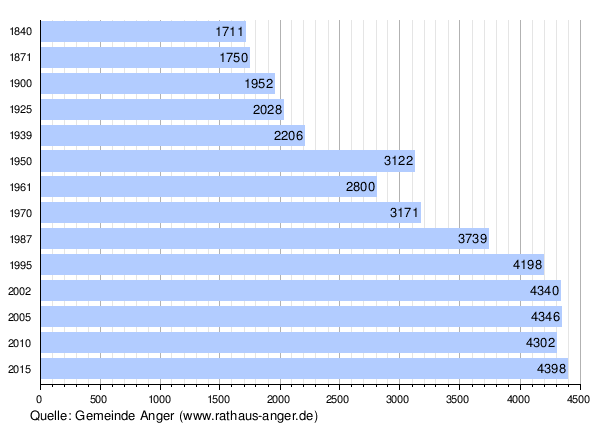
Population development of the municipality
Between 1988 and 2018, the community grew from 3,858 to 4,542 by 684 inhabitants or 17.7%.
politics
Municipal council
According to the result of the 2020 municipal council election on March 15, the Anger municipal council has been composed as follows from May 1, 2020 to the end of April 2026:
| Party / list | Seats |
| Christian Social Union in Bavaria (CSU) | 7th |
| Free voter community Anger-Högl-Aufham | 5 |
| Together for Anger | 4th |
Compared to the 2014 to 2020 term of office, the Free Voting Community lost two mandates, with the CSU and Miteinand ' each being able to win an additional seat for Anger .
mayor
Markus Winkler (CSU) has been the first mayor since May 1, 2020. It prevailed over its competitor with 71.0%. His predecessor Silvester Enzinger (CSU), who was in office from May 1, 1996 to April 30, 2020, did not apply for another term of office.
Banner and coat of arms


|
|
Blazon : "Two crossed silver keys in red, above a silver pilgrim's shell, underneath a silver Raitelhaken." |
|
Justification of the coat of arms: The coat of arms of the municipality of Anger refers with the composition of the figures to the incorporation of the formerly independent municipalities Aufham and Högl into it in 1978 . Elements have been adopted from all three municipal coats of arms up to 1978. The tinging in red and silver refers to the historical affiliation of the municipality to the Prince Archbishopric of Salzburg until 1803. The crossed keys, as attributes of St. Peter, remind us that Anger (until 1937 Stoißberg) was donated to the St. Peter monastery in Salzburg as early as 1000 and later came to the Augustinian monastery Höglwörth as endowment , which also had the crossed keys in the coat of arms because of the same patron saint. The Raitelhaken, a lifting tool for the transport of stones, comes from the former municipality coat of arms of Högl and refers to the sandstone quarries that were operated in Oberhögl from the 16th century to 1913 and were used for the production of window and door frames, grinding and Whetstones were of national importance. The pilgrim shell was taken from the Aufham coat of arms as a symbol and, as an attribute of St. Jacob, refers to the local church patronage.
The coat of arms was introduced in 1980 on the legal basis of a resolution of the municipal council and with the consent of the government of Upper Bavaria . (The letter from the government of Upper Bavaria is dated July 30, 1980.) The municipality colors of the flag are: white - red - white. |
Culture and sights
See also: List of architectural monuments in Anger (Berchtesgadener Land) and List of soil monuments in Anger (Berchtesgadener Land)
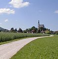
Parish Church of St. Mary of the Assumption seen from the south

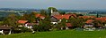
Church and market square in Anger

Church of Anger seen from the direction of Aufham
View of Steinhögl
.jpg)


tradition
Many old customs and traditions have been preserved in the area around Anger-Aufham-Högl. Religious customs are particularly pronounced. In the old tradition, numerous church festivals are celebrated, but customs of pagan origin are also cultivated. These include old folk dances, the Aperschnalzen , the Kramperllauf , the Schuhplattler , the traditional costumes, the traditional construction of the houses, the dialect and the great attachment of the population to music as an expression of traditional customs. A total of three music bands (Bergschützenkapelle Anger, Trachtenkapelle Anger-Höglwörth, Musikkapelle Aufham) provide background music and entertainment for various secular and religious occasions.
Sports and sports clubs
With the SC Anger , the municipality has a sports club whose wrestling division fought in the wrestling league for years .
economy
For a long time, the area of the municipality of Anger was dominated by agriculture.
In the valleys close to the mountains, the main source of income was forestry and forestry, which supplied wood for mining on the Kressenberg ( Neukirchen am Teisenberg , ore mining), smelting in Achtal , the salt works in Hallein and the iron hammer mill in Hammerau . Since there were few forests around Salzburg, firewood was also brought to the state capital.
In the foothills of the Alps, agriculture and cattle breeding were the main activities, and fishing on lakes. Mainly wheat, millet, spelled and rye were grown and cattle, horses, goats, pigs and poultry such as ducks, geese and chickens were kept as cattle. In the larger towns (cities and markets) the population mostly lived from handicrafts and trade. This structure remained until the middle of the 20th century and only changed with the onset of tourism.
In 2011, 363 employees commuted to the municipality of Anger, 1156 were out-commuters, so the out-commuters outnumbered 793 people.
Infrastructure
- Transmitter Högl , 157 meters high guyed transmission tower of the German radio tower (television and FM base station network)
- The federal motorway 8 runs through the municipality of Anger . The community has its own makeshift connection point .
Sons and daughters of the place (born or raised)
- Korbinian Birnbacher (* 1967), Benedictine Archabbot of St. Peter in Salzburg
- Stefan Klinger (* 1978), ski mountaineer
- Stefanie Koch (* 1981), ski mountaineer and alpine athlete
- Sebastian Höglauer (* 1990), musician, composer and arranger
Individual evidence
- ↑ "Data 2" sheet, Statistical Report A1200C 202041 Population of the municipalities, districts and administrative districts 1st quarter 2020 (population based on the 2011 census) ( help ).
- ↑ a b City Council. Parish of Anger, accessed on May 24, 2020 .
- ^ Community of Anger in the local database of the Bavarian State Library Online . Bavarian State Library, accessed on December 23, 2017.
- ^ Wilhelm Volkert (ed.): Handbook of Bavarian offices, communities and courts 1799–1980 . CH Beck, Munich 1983, ISBN 3-406-09669-7 , p. 434 .
- ^ Federal Statistical Office (ed.): Historical municipality directory for the Federal Republic of Germany. Name, border and key number changes in municipalities, counties and administrative districts from May 27, 1970 to December 31, 1982 . W. Kohlhammer GmbH, Stuttgart / Mainz 1983, ISBN 3-17-003263-1 , p. 597 .
- ↑ Reg. V. OB v. 01.03.1982, RABl No. 4 v. March 19, 1982, p. 25
- ↑ List of the former unincorporated areas in Bavaria
- ↑ wahl.info Donaukurier, result of the local election 2020 in Anger
- ↑ Announcement of the results of the election of the municipal council on March 15, 2020. Election supervisor for the municipality of Anger, accessed on May 31, 2020 .
- ↑ a b c d Entry on the coat of arms of Anger (Berchtesgadener Land) in the database of the House of Bavarian History , accessed on September 7, 2017 .
- ↑ No more first division wrestling in Anger. April 1, 2010, online at www.bgland24.de, accessed on April 22, 2017.
- ↑ Community report June 2013, p. 6 (PDF, 240 kB), accessed on November 3, 2015
Web links
- Official website of the municipality of Anger
- Entry on the coat of arms of Anger (Berchtesgadener Land) in the database of the House of Bavarian History
- Pfarrdorf Anger in the local database of the Bavarian State Library Online . Bavarian State Library

Ainring | Anger | Bad Reichenhall | Bayerisch Gmain | Berchtesgaden | Bischofswiesen | Freilassing | Running | Marktschellenberg | Piding | Ramsau near Berchtesgaden | Saaldorf-Surheim | Schneizlreuth | Schönau am Koenigssee | Teisendorf
Unparished areas:
Eck |
Schellenberger Forest