Bœsenpiesen
| Bœsenpiesen | ||
|---|---|---|

|
|
|
| region | Grand Est | |
| Department | Bas-Rhin | |
| Arrondissement | Sélestat-Erstein | |
| Canton | Sélestat | |
| Community association | Ried de Marckolsheim | |
| Coordinates | 48 ° 14 ' N , 7 ° 34' E | |
| height | 168-173 m | |
| surface | 3.81 km 2 | |
| Residents | 321 (January 1, 2017) | |
| Population density | 84 inhabitants / km 2 | |
| Post Code | 67390 | |
| INSEE code | 67053 | |
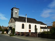
 Mairie Bœsenbiesen |
||
Bœsenbiesen ( German Bösenbiesen ) is a French commune with 321 inhabitants (as of January 1, 2017) in the Bas-Rhin department in the Grand Est region (until 2015 Alsace ).
geography
The Canal de la Marne au Rhin runs on the eastern side .
The municipality borders on Schobsheim in the northeast, Artolsheim in the east and south, Hessenheim in the south, Mussig in the southwest and Baldenheim in the west and northwest.
population
| 1962 | 1968 | 1975 | 1982 | 1990 | 1999 | 2006 | 2012 |
|---|---|---|---|---|---|---|---|
| 222 | 227 | 229 | 237 | 239 | 272 | 296 | 303 |
literature
- Le Patrimoine des Communes du Bas-Rhin . Flohic Editions, Volume 1, Charenton-le-Pont 1999, ISBN 2-84234-055-8 , p. 586.
Web links
Commons : Bœsenbiesen - collection of images, videos and audio files

