Lungro
| Lungro | ||
|---|---|---|

|
|
|
| Country | Italy | |
| region | Calabria | |
| province | Cosenza (CS) | |
| Coordinates | 39 ° 45 ′ N , 16 ° 7 ′ E | |
| height | 650 m slm | |
| surface | 35 km² | |
| Residents | 2,364 (Dec. 31, 2019) | |
| Population density | 68 inhabitants / km² | |
| Post Code | 87010 | |
| prefix | 0981 | |
| ISTAT number | 078069 | |
| Popular name | Lungresi ( Albanian Ungënjotë ) | |
| Patron saint | San Nicola (December 6th) | |
| Website | Lungro | |
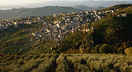
 View of Lungro |
||
Lungro (in Arbëresh , IPA : [ar'bəreʃ] : Ungra ) is a southern Italian municipality with 2364 inhabitants (as of December 31, 2019) in the province of Cosenza in Calabria .
Location and dates
The area of the municipality lies at an altitude of 650 m above sea level in the Pollino National Park and covers an area of 35 km² . Lungro is about 67 km north of Cosenza .
The neighboring municipalities are Acquaformosa , Altomonte , Firmo , Orsomarso , San Donato di Ninea and Saracena .
history
The place was founded around 1468 by Albanians who immigrated in the 15th century from what is now the states of Albania and Greece .
Since 1919 Lungro has been the seat of the Lungro Eparchy of the Italo-Albanian Church .
Web links
- Information at comuni-italiani.it (Italian)
Commons : Lungro - collection of images, videos and audio files
Individual evidence
- ↑ Statistiche demografiche ISTAT. Monthly population statistics of the Istituto Nazionale di Statistica , as of December 31 of 2019.

