
Manatuto (municipality)
|
Munisípiu Manatutu (tetum) Município de Manatuto (port.) |
||

|
||
| Data | ||
| Capital | Manatuto | |
| surface | 1,783.34 km² (3.) | |
| Population (2015) | 46,619 (13.) | |
| Population density | 26.14 inh / km² (13.) | |
| Number of households (2015) | 7,467 (13.) | |
| ISO 3166-2: | TL-MT | |
| Administrative offices | Residents | surface |
| Barique | 5,438 | 398.29 km² |
| Laclo | 7,756 | 283.29 km² |
| Laclubar | 12,050 | 399.79 km² |
| Laleia | 3,689 | 226.08 km² |
| Manatuto | 14,392 | 345.88 km² |
| Soibada | 3,294 | 130.02 km² |
| map | ||

|
||
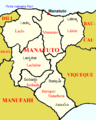
Manatuto ( tetum Manatutu ) is the third largest community in East Timor . The name is derived from "Manatutu" , the Galoli word for "pecking birds".
geography


Since the territorial reform in 2015, Manatuto has an area of 1783.34 km² (before: 1785.96 km²). The capital of the municipality is Manatuto of the same name . Manatuto is divided into the six administrative offices Barique , Laclo , Laclubar , Laleia , Manatuto and Soibada . The administrative boundaries of the administrative posts and sucos were changed, in some cases very significantly, in 2015 (see maps). The sucos Ailili and Aiteas are classified as urban.
The municipality is located in the middle of the country and stretches from the north coast on the Wetar Strait to the south coast on the Timor Sea . The communities of Baucau and Viqueque border in the east, Manufahi , Aileu and Dili in the west . The two coastal regions are separated by mountains in the center of the island that reach a height of over 2000 m . Soibada and Barique are mostly forested, while there is hardly any forest in Laleia.
The Northern Lacló flows through the administrative office Laclo, where several rivers flow into it and reaches the Timorese north coast between the Ponta de Subaio and the Baía de Lanessana near Manatuto. The Rio Dilor forms the majority of the eastern border of the Barique administrative office to the municipality of Viqueque , while the western border is determined by the Sáhen River .
The climate is tropical. However, the annual rainfall in the municipality is very different. The northern part of Manatuto is one of the driest regions in Timor. In the municipal capital of Manatuto there is an average of only 565 mm of rainfall per year. The northern Lacló alone supplies the region with water in the dry season. It is one of the few rivers in north Timor that has water all year round, as it is also fed from the south. The mountains in the center of Manatuto receive most of the rain of the year, the south coast is also better supplied with water with around 1500 mm of rainfall per year. Sáhen and Dilor in particular threaten the south of Barique with flooding during the rainy season. Rain falls mainly in the rainy season, which takes place at different times in the north and south of the municipality. The temperature in the dry season varies between 18 and 32 ° C in the south and 20 and 32 ° C in the north.
There are several Important Bird Areas in the Manatuto community . On the north coast there is an area around Mount Curi . In the center is the area around the mountain Diatuto and in the south the area of the mountains Makfahik and Sarim .

Administrative boundaries 2004–2015
Localities in Manatuto

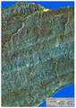
Road network and topography of Manatuto
Rice growing areas in Manatuto

Manatuto climate diagram
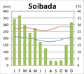
Climate diagram of Soibada

Uma Boco climate diagram


Residents


46,619 people live in Manatuto (2015, 2011: 44,906 inhabitants). The population density is 26.14 inhabitants / km², making the municipality in East Timor the most sparsely populated. The average age is 18.7 (2010). Between 1990 and 2004 the number of inhabitants grew by 1.06% annually. In 2004, each woman in Laleia had an average of 4.98 children, the number rose to over 6.18 children in Soibada, 6.35 in Barique, 6.50 in Manatuto and 6.51 in Laclubar, up to 7.25 children per woman in Laclo (national average 6.99). The rate of teenage mothers was also particularly high in Laclo. The infant mortality rate in Laleia in 2002 was 19 deaths per 1000 live births (1996: 79). Although this is the largest decrease in the country, it is assumed that there was an error in the collection of the data. 69 children died in Barique (72), in Manatuto 73 (92), in Soibada 89 (78), in Laclo 114 (148) and in Laclubar 143 (122). The national average was 98. Soibada and Laclubar are two of 14 administrative offices in which child mortality rose contrary to the national trend.
Several national languages are spoken as mother tongue in the community . 29.9% speak Galoli (largest language group in the administrative offices of Laclo, Laleia and Manatuto); 28.8% speak the Idalaka language Idaté (Laclubar administrative office); 22.4% speak Tetum , mostly Tetum Terik (administrative offices Barique and Soibada); 6.6% speak Mambai (Bazartete Administrative Office); 4.0% speak Habun in the center of the community; 4.0% speak the dialect Dadu'a of Atauru . It is spoken by the descendants of residents of the island of Atauros who emigrated to the villages of Manatuto. Around 1000 residents speak Midiki and 260 Kairui , both of which belong to the Kawaimina languages. If the second languages are also taken into account, in 2015 91.1% spoke Tetum, 37.1% Bahasa Indonesia, 30.2% Portuguese and 14.0% English .
In 2004 97.5% of the population were Catholics , 1.9% followers of the traditional, animistic religion of Timor and 0.2% Protestants . The 2015 census recorded 98.49% Catholics, 1.07% Protestants, 43 Buddhists, 34 Muslims and only 27 animists.
In 2015, 39.8% of residents aged three or over attended school. 30.5% had left school. 27.9% have never attended school, which is roughly the national average. 10.4% of Manatuto's residents only attended pre-school, just under a third only attended primary school. Just under a quarter of the population have completed secondary schools. 2.7% have a diploma or a degree, which is half the national average. The illiteracy rate in 2015 was 17.4% (women: 17.5%; men: 17.3%). In 2004 it was still 60.6%.
| Education | Graduation | ||||||||||
| at school | Finished school | never in a school | Preschool | primary school | Pre- secondary |
Secondary | Diploma / University of Applied Sciences |
university | No graduation | ||
| Women | 38.4% | 28.9% | 30.7% | 9.9% | 29.7% | 11.6% | 11.3% | 0.4% | 1.8% | 1.0% | |
| Men | 41.2% | 32.0% | 25.2% | 10.8% | 32.0% | 11.7% | 12.8% | 0.6% | 2.6% | 1.0% | |
| total | 39.8% | 30.5% | 27.9% | 10.4% | 30.9% | 11.7% | 12.1% | 0.5% | 2.2% | 1.0% | |
history

Barique, Laclo, Laclubar, Laleia and Manatuto were among the traditional riches of Timor ruled by a liurai . They appear on a list by Afonso de Castro , a former governor of Portuguese Timor who listed 47 empires in 1868.
In 1670 Franciscans founded missions in Manatuto and Laclo . In 1752 a church was also built in Manatuto. While Christian centers emerged here, until the end of the 19th century in the highlands hardly any Timorese people recognized Christianity. Although the Dominican Manuel de Santo António had evangelized in Samoro at the beginning of the 18th century and converted the local Liurai to Christianity, no more Christians were registered in the highlands in 1856, while 700 Christians lived in Manatuto and 370 in Laclo.
In 1730 the Portuguese governor Pedro de Melo (1729 to 1731) moved to Manatuto and had to repel the attack by 15,000 warriors there. After 85 days he managed to break the siege. Although he was unable to drive the rebels out of this region, he made alliances with the Liurai of Manatuto and other local rulers - a circumstance that should facilitate the relocation of the colonial capital from Lifau to Dili in 1769. Governor Feliciano António Nogueira Lisboa (1788 to 1790) got into a dispute with the representative of the Catholic Church in Manatuto, the monk Francisco Luis da Cunha . Both accused each other of robbery and the theft of customs revenue, among other things. To get rid of the governor, the monk incited the people of Manatuto to rebellion. Christianized Timorese threatened to spread the revolt to all of Belu . Finally, the Viceroy of Goa took action, had both men arrested and deported from Timor. The new governor Joaquim Xavier de Morais Sarmento (1790 to 1794) brought the situation back under control. Around 1800 a company of Moradores was stationed in Manatuto , which secured Portugal's influence in the important center of the domain. From 1810 to 1812 the post of governor was vacant and a Conselho Governativo led the fortunes of the colony. A member of the council was the bishop of the colony, who resided in Manatuto between 1769 and 1877.

In the spring of 1861, revolts broke out in Laclo against forced labor on public projects. Governor Afonso de Castro then sent Cabeira , a veteran and expert on the country, to set up a base in Manatuto. But he could only fall back on a few troops from Vemasse . There was already fighting in April. On August 26, the rebellion in Laclo was put down. The rebel camp was burned down and local allies were allowed looting and headhunting of the rebels. In June 1863 an uprising in Laga was put down. The rebel chief was captured by Laclo.
In 1882 there was fighting between Vemasse and Laleia, for which the Portuguese commander of the military headquarters was held responsible. In 1889 a military post was built in Manatuto in order to better control trade. In 1899, Jesuits and sisters of the Canossians founded the mission in Soibada , which at that time consisted of simple huts. The vicar general , who was responsible for the south of the colony, took his seat here in 1900. In the same year construction began on the home of the missionaries, the Church of the Sacred Heart of Jesus and two Colégios . The Colégio Nuno Álvares Pereira for the boys opened in 1904. The Colégio da Imaculada Conceição for girls started operating around 1910. Soibada was the religious and educational center in Timor at that time. On December 23, 1910, however, the Jesuits were expelled from Soibada by order of the new, republican administration. For the Portuguese this meant a setback for their influence in this region for years. Only with the new Portuguese constitution of 1933 and the laws of 1935 was the decree of 1910 repealed. During the Manufahi rebellion , fighting broke out again in the region in 1912. On October 13, 1936, the Nossa Senhora da Fatima seminary was founded in Soibada . There was also a school for the formation of catechists, the Escola São Francisco Xavier . The Mission's buildings escaped destruction by the Japanese in World War II as the local ruler Raimundo Doutel Sarmento stood up for them. But after the war, Soibada began to decline. In 1951 the seminary and catechist school were moved to Dare and a diocese was established in Barique .

In September 1975, as a result of the civil war between FRETILIN and União Democrática Timorense (UDT), ten UDT members were murdered in what was then the Manaturo district. On September 4, FRETILIN units attacked the village of Hatu Conan and captured twelve UDT members. Nine of them were murdered. A tenth victim was captured on September 7th, first shot and then beheaded.
Soibada became the headquarters of FRETILIN immediately after the Indonesian invasion in 1975. At their congress here in May 1976, the previous Prime Minister of East Timor, Nicolau dos Reis Lobato, was officially elevated to military command. With the exception of Manatuto, bases de apoio were created in all the subdistricts of the Manatuto district at that time , in which the civilian population who had fled had settled. At the end of 1977 the Indonesian army began destroying these resistance bases. People were dispersed or captured. By June 1978 the district was finally completely under Indonesian control.
In 2014, the districts across East Timor were transformed into "parishes" and the sub-districts into "administrative offices".
politics
| Administrador Konsellu |
|
|---|---|
| João da Cruz Caleres Jùnior | around 1942 |
| Luís da Silva | until the Carnation Revolution in 1974 |
|
District President (Bupati) |
|
| Luís Maria da Silva ( APODETI ) | May 1976-1984 |
| Elías Enes Cárceres | 1984-1989 |
| José Abílio Osório Soares | 1989-1994 |
| Vidal Doutel Sarmento | 1994-2002 |
|
Civil Administrator |
|
| Abel dos Santos Fátima | 2000-2002 |
|
Administrador |
|
| Mateus Ximenes Belo | 2001 |
| Elvino Bonaparte do Rego | 2002 - 2011 (?) |
| Gaspar da Silva | around 2012 |
| Aleixo Soares | around 2014 to August 7, 2015 |
| Fernando Domingos de Almeida Sousa Júnior | since August 7, 2015 |


Government president (Bupati) during the Indonesian occupation was among others José Abílio Osório Soares , who was the last Indonesian governor of East Timor from September 1992.
Today the administrator of the municipality is appointed by the East Timorese regional government in Dili. Abel dos Santos Fátima held this post under UN administration (2000–2002). In 2001, Mateus Ximenes Belo was administrator . In December 2003 and July 2011 the office was held by Elvino Bonaparte do Rego , but in March 2012 by Gaspar da Silva . The administrator in February 2014 was Aleixo Soares . On August 7, 2015, Fernando Domingos de Almeida Sousa Júnior was appointed as the new administrator.
In the elections for the constituent assembly , from which the national parliament later emerged, FRETILIN in Manatuto won the most votes with 47.57%, so that it received the direct mandate at that time. In the 2007 parliamentary elections , the Congresso Nacional da Reconstrução Timorense (CNRT) succeeded in becoming the strongest force in Manatuto with 33.18% of the vote. In the parliamentary elections in 2012 , the CNRT was able to build on its success with 45.39% of the vote. In 2017 , the CNRT received 31.5% of the vote, the FRETILIN 20.5%. In the early elections in 2018 , the Aliança para Mudança e Progresso (AMP) , to which the CNRT now belonged, received 61.7% of the vote.
In the 2007 presidential elections , the independent candidate and later election winner José Ramos-Horta won the most votes in the first round in Manatuto. In the second round he received 80.73%. In the 2012 presidential elections , the eventual winner Taur Matan Ruak also won in the first round in Manatuto. He received 35% of the vote. In the runoff election, Taur Matan Ruak got 73.55% in Manatuto. In the 2017 presidential elections in Manatuto, the nationwide winner Francisco Guterres from FRETILIN won the most votes.
Economy and Infrastructure
| Share of households with ... | ||
| agriculture | ||
| Field crops | Share 2010 | Production 2008 |
| Corn | 52% | 8,550 t |
| rice | 30% | 5,175 t |
| manioc | 50% | 1,998 t |
| coconuts | 39% | not specified |
| vegetables | 39% | 358 t (with fruit) |
| coffee | 11% | not specified- |
| Livestock | ||
| Livestock | Share 2010 | Number of animals 2010 |
| Chicken | 73% | 24,635 |
| Pigs | 74% | 14,363 |
| Bovine | 23% | 6,204 |
| Water buffalo | 19% | 8,551 |
| Horses | 26% | 3.115 |
| Goats | 33% | 8,575 |
| Sheep | 6% | 4,048 |
| Furnishing | Share 2010 | Number of households |
|---|---|---|
| radio | 25% | 1,734 |
| watch TV | 20% | 1,382 |
| Telephone (mobile / landline) | 45% | 3.114 |
| fridge | 7% | 513 |
| bicycle | 14% | 956 |
| motorcycle | 9% | 591 |
| automobile | 3% | 217 |
| boat | 2% | 166 |

_Manatuto.jpg)
According to the 2010 census, 40% of all residents who are ten years or older work (national average: 42%). 4% are unemployed (5%). 65.7% of households practice arable farming, 87.7% cattle (as of 2010). In Uma Boco (Natarbora) there is an agricultural college.
52% of the households in the municipality grow maize (production 2008: 8550 t), 50% manioc (1998 t), 39% coconuts, 30% rice (5175 t) and 30% coffee. In addition, light nuts , fruits and vegetables are grown for commercial purposes (a total of 944 t). People mainly keep chickens (24,635 in 73% of households) and pigs (14,363 in 74% of households) as pets. In addition, goats (8,575 in 33% of households), water buffalo (8,551 in 19% of households), sheep (4,048 in 6% of households), cattle (6,204 in 23% of households) and horses (3,115 in 26% of households ).
There are only small amounts of mineral resources. Marble, plaster of paris, gold, iron, magnesium, zinc, crude oil, natural gas and chrome can be found in Manatuto.
In front of the north coast there are species-rich coral banks that are suitable for diving tourism, for example in Suco Uma Caduac .
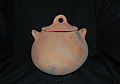
- Pottery in Manatuto


The municipal radio station Radio Communidade Ili Wai broadcasts on FM 96.1 MHz. The FRETILIN radio station Radio Ma 2500 can be received on FM 93.8 MHz. 25% of households have a radio. 20% have a television. In 45% of households there is a fixed telephone line or a cell phone.
Few residents of Manatuto have their own vehicle. Only 9% of households have a motorcycle, only 3% have a car and only 14% of households have a bicycle.
93% of Manatuto's households live in their own house, with another 4% the house belongs to another family member. Only a quarter of all residential buildings are made of brick or concrete. Most of the buildings are still made from natural materials such as bamboo, palm fronds or clay. Zinc and iron sheets have prevailed in many places for roofs. However, 37% of the houses are still covered with palm fronds or thatch. In over half of the houses, the floor consists of rammed earth, in 23% of concrete. Overall, the natural materials in Manatuto are somewhat more widespread than the national average. 69% of households have access to clean drinking water sources (similar to the national average), with only 20% having the water on or in the house. The residents of the other households have to get the drinking water from public pipes, wells, springs or bodies of water. Almost all households use wood for cooking. The national average is 3% less. 38% use electricity as a light source, and almost a third of Manatuto's residents use petroleum to generate light. 10% use candles and 7% the light nut . In the national average, half use petroleum and over a third use electricity.
| Share of households with ... | ||||||||
| ... house walls made of ... | ||||||||
| Brick / concrete | Wood | bamboo | Clay | Iron / zinc sheet | Palm fronds | Natural stones | Others | |
| 25% | 3% | 38% | 4% | 0% | 28% | 1 % | 0% | |
| ... roofs made of ... | ... floors made of ... | |||||||
| Palm fronds / straw / bamboo | Iron / zinc sheet | Roof tiles | Others | concrete | Tiles | Soil / loam | Bamboo / wood | Others |
| 37% | 53% | 0% | 9% | 23% | 4% | 52% | 13% | 7% |
| Drinking water supply through ... | ||||||||
| Pipe or pump in the house | Line or pump outside | Public pipeline, well, borehole | protected source | unprotected source | Surface water | Others | ||
| 3% | 17% | 38% | 11% | 9% | 21% | 1 % | ||
| Energy source for cooking | Light source | |||||||
| electricity | petroleum | Wood | Others | electricity | petroleum | Wood | Light nut / candle berry |
Others |
| 2% | 3% | 93% | 1 % | 38% | 32% | 5% | 7% | 18% |
Partnerships
-
 Torres Novas , Portugal (since May 2000)
Web links
- District Profile 2013 (tetum, PDF file)
- Planu Estartejiku Desenvolvimentu Munisipal (Portuguese)
supporting documents
- Ministry of State Administration and Territorial Management
- Manatuto District Development Plan 2002/2003 (PDF 829 kB)
Individual evidence
- ↑ a b c d e f g h i j k l m n o Direcção-Geral de Estatística : Results of the 2015 census , accessed on November 23, 2016.
- ↑ Geoffrey Hull : The placenames of East Timor , in: Placenames Australia (ANPS): Newsletter of the Australian National Placenames Survey, June 2006, pp. 6 & 7, ( Memento of the original from February 14, 2017 in the Internet Archive ) Info: The archive link was inserted automatically and has not yet been checked. Please check the original and archive link according to the instructions and then remove this notice. accessed on September 28, 2014.
- ↑ a b c d Direcção Nacional de Estatística: 2010 Census Wall Chart (English) ( Memento of the original dated August 12, 2011 in the Internet Archive ) Info: The archive link was inserted automatically and has not yet been checked. Please check the original and archive link according to the instructions and then remove this notice. (PDF; 2.7 MB)
- ↑ Seeds of Life Timor: Rainfall Map of East Timor 2000–2050 (PDF; 1 MB)
- ↑ UN Office for the Coordination of Humanitarian Affairs: Flood Hazard Map, Timor-Leste, November 19, 2007
- ↑ Important Bird Areas in Timor-Leste (PDF)
- ↑ Statistical Office of East Timor: Results of the 2010 census of the individual sucos ( Memento of January 23, 2012 in the Internet Archive )
- ↑ Direcção Nacional de Estatística: Timor-Leste in figures 2011 (PDF; 3.8 MB) ( Memento of the original from February 19, 2014 in the Internet Archive ) Info: The archive link was inserted automatically and has not yet been checked. Please check the original and archive link according to the instructions and then remove this notice. , accessed May 5, 2013
- ↑ a b Census of Population and Housing Atlas 2004 ( Memento of November 13, 2012 in the Internet Archive ) (PDF; 14 MB)
- ↑ District Pritory Tables: Manatuto 2004 ( Memento of the original from May 20, 2011 in the Internet Archive ) Info: The archive link was inserted automatically and has not yet been checked. Please check the original and archive link according to the instructions and then remove this notice. (PDF; 13 MB)
- ↑ TIMOR LORO SAE, Um pouco de história ( Memento of the original dated November 13, 2001 in the Internet Archive ) Info: The archive link was inserted automatically and has not yet been checked. Please check the original and archive link according to the instructions and then remove this notice.
- ^ East Timor - Portuguese Dependency of East Timor ( Memento of February 21, 2004 in the Internet Archive )
- ^ A b Judith Bovensiepen, Frederico Delgado Rosa: Transformations of the sacred in East Timor , accessed December 27, 2017.
- ^ Artur Teodoro de Matos: D. Frei Manuel de Santo António: missionário e primeiro bispo residente em Timor. Elementos para a sua biografia (1660-1733) ( Memento of the original from May 25, 2013 in the Internet Archive ) Info: The archive link was inserted automatically and has not yet been checked. Please check the original and archive link according to the instructions and then remove this notice. (Portuguese)
- ↑ a b Chronologie de l'histoire du Timor (1512–1945) suivie des événements récents (1975–1999) (French; PDF; 887 kB)
- ↑ History of Timor ( Memento of the original from March 24, 2009 in the Internet Archive ) Info: The archive link was automatically inserted and not yet checked. Please check the original and archive link according to the instructions and then remove this notice. , P. 43 - Technical University of Lisbon (PDF file; 805 kB)
- ^ History of Timor, p. 50
- ↑ a b c d Geoffrey C. Gunn: History of Timor. ( Memento of the original from March 24, 2009 in the Internet Archive ) Info: The archive link was inserted automatically and has not yet been checked. Please check the original and archive link according to the instructions and then remove this notice. Technical University of Lisbon (PDF file; 805 kB)
- ↑ a b c Património de Influência Portuguesa: Mission of the Sacred Heart of Jesus , accessed on November 15, 2016.
- ↑ "Chapter 7.2 Unlawful Killings and Enforced Disappearances" ( Memento of the original from March 25, 2016 in the Internet Archive ) Info: The archive link was inserted automatically and has not yet been checked. Please check the original and archive link according to the instructions and then remove this notice. (PDF; 2.5 MB) from the "Chega!" Report by CAVR (English)
- ↑ "Chapter 7.3 Forced Displacement and Famine" ( Memento of the original from November 28, 2015 in the Internet Archive ) Info: The archive link was inserted automatically and has not yet been checked. Please check the original and archive link according to the instructions and then remove this notice. (PDF; 1.3 MB) from the "Chega!" Report by CAVR (English)
- ↑ Kisho Tsuchiya: Indigenization of the Pacific War in Timor Island: A Multi-language Study of its Contexts and Impact , p. 12, Journal War & Society, Vol. 38, No. February 1, 2018.
- ^ Antero Bendito da Silva, Robert Boughton , Rebecca Spence: FRETILIN Popular Education 1973-1978 and its Relevance to Timor-Leste Today , University of New England, 2012, accessed June 5, 2019.
- ↑ "Part 4: Regime of Occupation" ( Memento of the original from January 18, 2012 in the Internet Archive ) Info: The archive link was inserted automatically and has not yet been checked. Please check the original and archive link according to the instructions and then remove this notice. (PDF) from the "Chega!" Report by CAVR (English)
- ↑ Masters of Terror: Jose Abilio Osorio Soares ( Memento of March 21, 2012 in the Internet Archive ) (English)
- ↑ Office of the Prime Minister: Address by his Excellency the Prime Minister Kay Rala Xanana Gusmão on the Occasion of the Swearing-in of Mr. Abel dos Santos Fátima as the Civil Service Commissioner , accessed on February 15, 2016.
- ↑ Curriculum Vitae. (PDF) Retrieved December 26, 2015 .
- ↑ World Bank: Participation List Timor-Leste and Development Partners Meeting 3-5 December 2003 , accessed April 27, 2020.
- ↑ Website of the East Timorese government: 2935 civil servants were sworn in by the Public Service Commission ( Memento of February 26, 2014 in the Internet Archive )
- ^ The Dili Weekly: Marsu, SEFOPE implementa projetu empregu rural iha distritu , March 13, 2012 , accessed on May 14, 2016.
- ^ Descentralização Administrativa na República Democrática de Timor-Leste: Manatuto , accessed on February 7, 2014
- ↑ Ministry of State Administration: Tomada de posse do novo Administrador do Município de Manatuto , August 7, 2015 ( Memento of the original of November 12, 2015 in the Internet Archive ) Info: The archive link was inserted automatically and has not yet been checked. Please check the original and archive link according to the instructions and then remove this notice. , (Portuguese). Retrieved November 4, 2015.
- ↑ Lurdes Silva-Carneiro de Sousa: Some Facts and Comments on the East Timor 2001 Constituent Assembly Election ( Memento of October 16, 2013 in the Internet Archive ) ( RTF ; 199 kB), Lusotopie 2001: pp. 299–311.
- ↑ CNE - official results on 9th July 2007 ( Memento from September 27, 2007 in the Internet Archive ) (PDF; 118 kB)
- ↑ CNE: CNE 2017
- ↑ CNE: Munisipios , accessed May 30, 2018.
- ↑ a b c d e f g h i j k l Direcção Nacional de Estatística: Suco Report Volume 4 (English) ( Memento of the original from April 9, 2015 in the Internet Archive ) Info: The archive link was inserted automatically and has not yet been checked. Please check the original and archive link according to the instructions and then remove this notice. (PDF; 9.8 MB)
- ↑ a b Direcção Nacional de Estatística: Timor-Leste in Figures 2008 ( Memento of the original from 7 July 2010 in the Internet Archive ) Info: The archive link was automatically inserted and not yet checked. Please check the original and archive link according to the instructions and then remove this notice. (PDF; 3.7 MB)
- ↑ Dive Timor Lorosae: Divesites Map
- ↑ ARKTL - Asosiasaun Radio Komunidade Timor-Leste (English)
- ↑ Municípios Portugueses: Geminações de Cidades e Vilas , accessed on January 7, 2018.
Coordinates: 8 ° 31 ' S , 126 ° 1' E