
Mornay berry
| Mornay berry | ||
|---|---|---|
|
||
| region | Center-Val de Loire | |
| Department | Cher | |
| Arrondissement | Saint-Amand-Montrond | |
| Canton | La Guerche-sur-l'Aubois | |
| Community association | Pays de Nérondes | |
| Coordinates | 47 ° 3 ' N , 2 ° 52' E | |
| height | 176-237 m | |
| surface | 9.15 km 2 | |
| Residents | 183 (January 1, 2017) | |
| Population density | 20 inhabitants / km 2 | |
| Post Code | 18350 | |
| INSEE code | 18154 | |
.JPG) City Hall (Mairie) of Mornay-Berry |
||

Mornay-Berry is a commune with 183 inhabitants (as of January 1 2017) in the department of Cher in the region Center-Val de Loire ; it belongs to the arrondissement of Saint-Amand-Montrond and is part of the canton of La Guerche-sur-l'Aubois (until 2015: canton of Nérondes ).
geography
Mornay-Berry is about 38 kilometers east-southeast of Bourges . Mornay-Berry is surrounded by the neighboring communities of Garigny in the north and north-east, Saint-Hilaire-de-Gondilly in the east, Chassy in the south and west and Villequiers in the north-west.
Population development
| year | 1962 | 1968 | 1975 | 1982 | 1990 | 1999 | 2006 | 2013 |
|---|---|---|---|---|---|---|---|---|
| Residents | 286 | 252 | 195 | 178 | 153 | 163 | 195 | 196 |
| Source: Cassini and INSEE | ||||||||
Attractions
- Saint-Sulpice church from the 12th / 13th centuries century
- La Grand'Cour castle from the 13th century
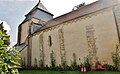
Saint-Sulpice church
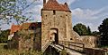
La Grand'Cour Castle
.JPG)
.JPG)
literature
- Le Patrimoine des Communes du Cher. Flohic Editions, Volume 2, Paris 2001, ISBN 2-84234-088-4 , pp. 707-708.
Web links
Commons : Mornay-Berry - Collection of images, videos and audio files