Saulzais-le-Potier
| Saulzais-le-Potier | ||
|---|---|---|

|
|
|
| region | Center-Val de Loire | |
| Department | Cher | |
| Arrondissement | Saint-Amand-Montrond | |
| Canton | Châteaumeillant | |
| Community association | Berry Grand Sud | |
| Coordinates | 46 ° 36 ′ N , 2 ° 30 ′ E | |
| height | 189-251 m | |
| surface | 32.38 km 2 | |
| Residents | 497 (January 1, 2017) | |
| Population density | 15 inhabitants / km 2 | |
| Post Code | 18360 | |
| INSEE code | 18245 | |
| Website | http://saulzais-le-potier.e-monsite.com/ | |
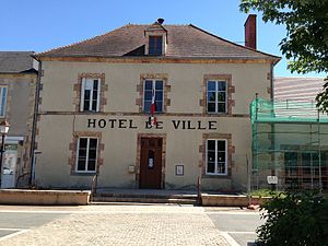
 Town hall (Mairie) of Saulzais-le-Potier |
||
Saulzais-le-Potier is a commune with 497 inhabitants (as of January 1 2017) in the department of Cher in the region Center-Val de Loire ; it belongs to the arrondissement of Saint-Amand-Montrond and the canton of Châteaumeillant (until 2015: canton of Saulzais-le-Potier ).
geography
Saulzay-le-Potier is about 60 kilometers south of Bourges . Saulzais-le-Potier is surrounded by the neighboring communities of Faverdines in the north and north-west, La Celette in the east and north-east, Épineuil-le-Fleuriel in the south and south-east and Vesdun in the west and south-west.
The A71 autoroute runs through the municipality .
Population development
| year | 1962 | 1968 | 1975 | 1982 | 1990 | 1999 | 2006 | 2013 |
|---|---|---|---|---|---|---|---|---|
| Residents | 660 | 621 | 513 | 476 | 473 | 492 | 527 | 501 |
| Source: Cassini and INSEE | ||||||||
Attractions
- Saint-Oustrille Church, built between 1860 and 1864
- La Landes Castle, Monument historique since 1992
Trivia
According to the calculations of the mathematician and priest Théophile Moreux , Saulzais-le-Potier was the center of France . Today he is seen in the neighboring municipality of Vesdun or in Nassigny .
literature
- Le Patrimoine des Communes du Cher. Flohic Editions, Volume 2, Paris 2001, ISBN 2-84234-088-4 , pp. 983-985.

