
La Celle (Cher)
| La Celle | ||
|---|---|---|
.svg)
|
|
|
| region | Center-Val de Loire | |
| Department | Cher | |
| Arrondissement | Saint-Amand-Montrond | |
| Canton | Saint-Amand-Montrond | |
| Community association | Coeur de France | |
| Coordinates | 46 ° 46 ′ N , 2 ° 27 ′ E | |
| height | 149-247 m | |
| surface | 12.80 km 2 | |
| Residents | 348 (January 1, 2017) | |
| Population density | 27 inhabitants / km 2 | |
| Post Code | 18200 | |
| INSEE code | 18042 | |

La Celle is a once to the small town of Bruère belonging municipality with 348 inhabitants (at January 1, 2017) in the French department of Cher in the region Center-Val de Loire .
In addition to the village located in the Cher valley , about 37 km south of Bourges on terrain reclaimed from the Meillant forest , there are also two hamlets belonging to La Celle.
Population development
| year | 1962 | 1968 | 1975 | 1982 | 1990 | 1999 | 2006 | 2012 |
| Residents | 317 | 342 | 264 | 264 | 291 | 328 | 355 | 344 |
Attractions
- The Romanesque church of Saint-Blaise was built in the course of the 12th century on the model of Benedictine sacred buildings. The unusual archaic sculptural decoration on the facade is well known. In addition to the remains of wall paintings and statues, the church houses the tomb of St. Silvanus from the 15th century.
- Saint-Sylvain chapel from the 15th century
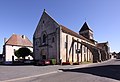
Saint Blaise Church
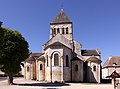
Choir page

Sculpture decoration on the choir side

Choir and apse


literature
- Le Patrimoine des Communes du Cher. Flohic Editions, Volume 2, Paris 2001, ISBN 2-84234-088-4 , pp. 726-728.
- Auvergne - Berry . The green travel guide. Travel House Media, Munich 2009, ISBN 978-3-8342-8982-7 , p. 267.
Web links
Commons : La Celle - collection of images, videos and audio files