
Saint-Hilaire-en-Lignières
| Saint-Hilaire-en-Lignières | ||
|---|---|---|

|
|
|
| region | Center-Val de Loire | |
| Department | Cher | |
| Arrondissement | Saint-Amand-Montrond | |
| Canton | Châteaumeillant | |
| Community association | Berry Grand Sud | |
| Coordinates | 46 ° 44 ′ N , 2 ° 10 ′ E | |
| height | 159-268 m | |
| surface | 53.78 km 2 | |
| Residents | 491 (January 1, 2017) | |
| Population density | 9 inhabitants / km 2 | |
| Post Code | 18160 | |
| INSEE code | 18216 | |

Saint-Hilaire-en-Lignières is a French municipality with 491 inhabitants (as of January 1 2017) in the department of Cher in the region Center-Val de Loire ; it belongs to the arrondissement of Saint-Amand-Montrond and the canton of Châteaumeillant (until 2015: canton of Lignières ).
geography
Saint-Hilaire-en-Lignières is located about 45 kilometers south-southwest of Bourges . Saint-Hilaire-en-Lignières is surrounded by the neighboring communities of Chezal-Benoît in the north and north-west, La Celle-Condé in the north and north-east, Lignières in the east, Touchay in the south-east, Rezay in the south and south-east, and Saint-Christophe-en-Boucherie to the south and south-west, La Berthenoux to the west and south-west and Pruniers to the west and north-west.
Population development
| year | 1962 | 1968 | 1975 | 1982 | 1990 | 1999 | 2008 | 2013 |
| Residents | 867 | 785 | 650 | 572 | 534 | 523 | 514 | 521 |
| Source: Cassini and INSEE | ||||||||
Attractions
- Saint-Hilaire church, historique monument since 1912
- Le Plaix Castle, Monument historique since 1995
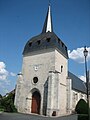
Saint-Hilaire church

Le Plaix Castle


literature
- Le Patrimoine des Communes du Cher. Flohic Editions, Volume 2, Paris 2001, ISBN 2-84234-088-4 , pp. 644-648.