Dun-sur-Auron
| Dun-sur-Auron | ||
|---|---|---|

|
|
|
| region | Center-Val de Loire | |
| Department | Cher | |
| Arrondissement | Saint-Amand-Montrond | |
| Canton | Dun-sur-Auron | |
| Community association | Le Dunois | |
| Coordinates | 46 ° 53 ' N , 2 ° 34' E | |
| height | 151-188 m | |
| surface | 50.09 km 2 | |
| Residents | 3,844 (January 1, 2017) | |
| Population density | 77 inhabitants / km 2 | |
| Post Code | 18130 | |
| INSEE code | 18087 | |
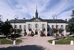
 Town Hall ( Hôtel de ville ) |
||
Dun-sur-Auron , the medieval Dun-le-Roy , one is commune with 3,844 inhabitants (at January 1, 2017) in the department of Cher in the region Center-Val de Loire ; it belongs to the arrondissement of Saint-Amand-Montrond and the canton of Dun-sur-Auron .
geography
The city lies on the Auron River and the abandoned Canal de Berry .
history
The Dunon ( lat. -Dunum ), which already existed in antiquity, was a fortified Gallic settlement or large settlement ( oppidum ). In the Middle Ages, the lordship of Dun-le-Roy belonged to the vice county of Bourges . The last owner, Eudes de Dun called Arpin, sold the vice-county to King Philip I in 1101 when he set out on the crusade . Dun as the third royal city in the Berry took the name Dun-le-Roy and King Philip August provided it with important fortifications.
Population development
- 1962: 3982
- 1968: 3995
- 1975: 4154
- 1982: 4238
- 1990: 4261
- 1999: 4013
- 2016: 3945
Attractions
- Saint-Etienne Collegiate Church, founded in 1109
- Castle remains (clock tower) from the 13th century
- City fortifications - 3 towers and remains of walls from the 12th century have been preserved
Personalities
- Laure Coutan (1855–1914) sculptor
- Agnès Godard (* 1951), camerawoman
literature
- Le Patrimoine des Communes du Cher. Flohic Editions, Volume 1, Paris 2001, ISBN 2-84234-088-4 , pp. 418-425.
