
Coust
| Coust | ||
|---|---|---|
|
||
| region | Center-Val de Loire | |
| Department | Cher | |
| Arrondissement | Saint-Amand-Montrond | |
| Canton | Dun-sur-Auron | |
| Community association | Coeur de France | |
| Coordinates | 46 ° 42 ′ N , 2 ° 36 ′ E | |
| height | 153-247 m | |
| surface | 21.89 km 2 | |
| Residents | 445 (January 1, 2017) | |
| Population density | 20 inhabitants / km 2 | |
| Post Code | 18210 | |
| INSEE code | 18076 | |
| Website | http://mairie.de.coust.free.fr/ | |

Coust is a French municipality with 445 inhabitants (as of January 1 2017) in the department of Cher in the region Center-Val de Loire ; it belongs to the arrondissement of Saint-Amand-Montrond and the canton of Dun-sur-Auron (until 2015: canton of Charenton-du-Cher ). The inhabitants are called Coustois .
geography
Coust is about 37 kilometers south-southeast of Bourges . The Cher limits the community in the southwest. Coust is surrounded by the neighboring communities of Saint-Pierre-les-Étieux in the north, Charenton-du-Cher in the north-east, Braize in the east and south-east, Lételon in the south, Ainay-le-Vieil in the south-west and Colombiers in the west and north-west.
Population development
| year | 1962 | 1968 | 1975 | 1982 | 1990 | 1999 | 2006 | 2013 |
| Residents | 503 | 503 | 518 | 460 | 506 | 475 | 467 | 457 |
| Source: Cassini and INSEE | ||||||||
Attractions
- Notre-Dame church from the 12th century, monument historique since 1911
- Cross of Thianges from 1472, monument historique since 1892
- Bonnais Castle from the 15th century
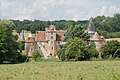
- Le Creuzet Castle, Monument historique since 2014

Notre-Dame church

Cross of Thianges
Bonnais Castle

Le Creuzet Castle


_-_Ch%C3%A2teau_du_Creuzet.JPG)
literature
- Le Patrimoine des Communes du Cher. Flohic Editions, Volume 1, Paris 2001, ISBN 2-84234-088-4 , pp. 264-266.