Obreja (Caraș-Severin)
|
Obreja Obrescha Obrézsa |
||||
|
||||
| Basic data | ||||
|---|---|---|---|---|
| State : |
|
|||
| Historical region : | Banat | |||
| Circle : | Caraș-Severin | |||
| Coordinates : | 45 ° 29 ' N , 22 ° 15' E | |||
| Time zone : | EET ( UTC +2) | |||
| Area : | 126.33 km² | |||
| Residents : | 3,287 (2014) | |||
| Population density : | 26 inhabitants per km² | |||
| Postal code : | 327285 | |||
| Telephone code : | (+40) 02 55 | |||
| License plate : | CS | |||
| Structure and administration (as of 2016) | ||||
| Community type : | local community | |||
| Structure : | Obreja, Ciuta , Iaz , Var | |||
| Mayor : | Ion Peia ( PSD ) | |||
| Postal address : | Str. Principală, no. 164 loc. Obreja, jud. Caraș-Severin, RO-327285 |
|||
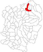
Obreja (German: Obrescha , Hungarian: Obrézsa ) is a municipality in the Caraș-Severin District , Banat , Romania . The municipality of Obreja also includes the villages of Ciuta , Iaz and Var .
Geographical location
Obreja is located in the northeast of the Caraş-Severin district, nine kilometers from Caransebeş , on the national road DN 68, on the left bank of the Bistra .
Neighboring places
| Maciova | Rusca Montana | Oțelu Roșu |
| Ciuta |

|
Glimboca |
| Păltiniș | Caransebeş | Var |
history
The village was first mentioned in a document in 1547. Obreja regularly appears in the documents of the time: in 1603 Stefan Rakoczy and Andrei Nagy were the landlords of So Obresia , 1628 was a donation of goods Obresa by Gabriel Bethlen Margareta and Sava Găman place in 1642 appear Felso Obresia and So Obresia in the documents, In 1783 Obreja was incorporated into the Wallachian-Illyrian Border Infantry Regiment No. 13 of the Banat Military Frontier .
As a result of the Austro-Hungarian Compromise of 1867, the Banat military border was dissolved. The Banat was placed under the Hungarian Crown. An oppressive process of Magyarization began. The official place name was Obrézsa .
The Treaty of Trianon on June 4, 1920 resulted in the Banat being divided into three parts , whereby Obreja fell to the Kingdom of Romania .
Population development
| census | Ethnicity | |||||||
|---|---|---|---|---|---|---|---|---|
| year | Residents | Romanians | Hungary | German | Other | |||
| 1880 | 3926 | 3879 | - | 38 | 9 | |||
| 1910 | 4815 | 4693 | 39 | 48 | 35 | |||
| 1930 | 4512 | 4495 | 4th | 1 | 12 | |||
| 1977 | 4129 | 3992 | 11 | 5 | 121 | |||
| 2002 | 3249 | 3171 | 15th | 7th | 56 | |||
Attractions
In 2014, the European Parliament's Foursquare list listed the Obreja Love Tunnel between Obreja and its western neighboring municipality Glimboca - a piece of the railway line between Bouțari and Caransebeș - a section of the railway line between Bouțari and Caransebeş that is “framed” by vegetation - as one of 28 recommended sights.
Web links
- primaria-obreja.ro , Obreja town hall
- ghidulprimariilor.ro , Obreja on the side of the Caraș-Severin County Council
- banaterra.eu , Obreja on the Banaterra website
- tunelul-iubirii , Obreja's love tunnel
Individual evidence
- ↑ Mayoral elections 2016 in Romania ( MS Excel ; 256 kB)
- ↑ a b primaria-obreja.ro , Obreja: History
- ↑ kia.hu (PDF; 858 kB), E. Varga: Statistics of the number of inhabitants by ethnicity in the Caraș-Severin district according to censuses from 1880 - 2002
- ↑ German Consulate Timisoara: Press review from August 5, 2014. Love tunnel in Karasch Severin
- ↑ foursquare.com , Re-discover Europe 2014
- ↑ wonderful-romania.com , The tunnel of love


