Poppenreuth (Fuerth)
|
Poppenreuth
City of Fürth
Coordinates: 49 ° 28 ′ 55 ″ N , 11 ° 0 ′ 55 ″ E
|
|
|---|---|
| Height : | 302 m above sea level NHN |
| Residents : | 1954 (May 25, 1987) |
| Incorporation : | January 1, 1900 |
| Postal code : | 90765 |
| Area code : | 0911 |
|
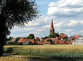
Poppenreuth from the south (2014)
|
|
Poppenreuth (colloquially: "Bobmraid") is a district of the independent city of Fürth in Middle Franconia .
geography
The parish village is about two kilometers east of the historic center of Fürth on the border with Nuremberg . In the east the Frankish borders Knoblauchsland to, on the south flows the Pegnitz and directly over the local area which runs approach path of the Nuremberg airport . Poppenreuth is connected to the Frankenschnellweg (A 73) via the Fürth-Poppenreuth junction (AS 37 ) and thus to the German trunk road network. A community road runs past Ronhof to Sack (2 km north), another community road runs to the war victims' settlement (1.4 km southeast).
history
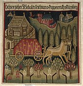
The place name means "clearing of the Poppo". The foundation of the village - as a small hamlet grouped around the church - is in the middle of the 9th century. The place was first mentioned in a document in 1303 in a document from the Nuremberg burgrave Konrad the Pious as "Boppenrevt". 7 farms were listed that were given as gifts to the Bamberg diocese . Around 1410 the church was laid out as a fortified church and was surrounded by a solid wall. The oldest illustration is a tapestry from this period. The illustration shows the ox cart which, according to legend, is said to have transported the coffin of St. Sebald von Poppenreuth to Nuremberg. In 1450 Poppenreuth was burned down in the First Margrave War . The year 1456 above the west entrance testifies to the reconstruction. The village was destroyed again in 1553 during the Second Margrave War. After the Reformation, 10 villages in the Knoblauchsland belonged to the Poppenreuth market district .
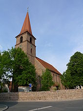
The now Protestant parish church of St. Peter and Paul was the mother church of St. Sebald in Nuremberg until the 13th century . In its present form with the striking west tower, the structure goes back to the early 15th century; the late Gothic choir , completed in 1522, is named Hans Beheim the Elder. Ä. attributed. The interior is characterized by a two-storey, now timber-framed nave gallery (1859/60). In the choir is a late Gothic winged altar (late 15th and early 16th centuries), which was put together in this form in the 19th century as a neo-Gothic work of art. The colored glass windows in the choir were made in 1881/82, with remains of panes from the 16th century being worked into the left window.
In the Thirty Years' War they suffered greatly from arson and famine. Only a quarter of the population of Poppenreuth remained. On an engraving from 1708, the center of the village is shown next to the church with the rectory, the village well and two inns.
At the end of the 18th century there were 39 properties in Poppenreuth. The high court exercised the Brandenburg-Ansbach Oberamt Cadolzburg , which was contested by the imperial city of Nuremberg . The village and township government had the bambergische Dompropsteiamt Fürth held. The landlords were the Dompropsteiamt Fürth (2 three-quarter courtyards, 4 half courtyards, 3 quarter courtyards, 4 small farms, 2 small houses, 2 taverns, 1 tavern, 1 shepherd's house); the imperial city of Nuremberg: Katharinenamt (1 estate), Landesalmosenamt (1 vicarage); the Röckenhof manor (4 estates, 1 bath house); Nuremberg owners: von Imhoff (2 estates), von Kreß (2 half yards), von Löffelholz (1 yard, 3 estates, 1 smithy), Burkard von Löffelholzscher Familienfideikomiss (1 estate), von Oelhafen (1 half yard, 2 estates).
From 1796 Poppenreuth was briefly under the Prussian King Friedrich-Wilhelm II . Ten years later, Prussian rule ended when Franconia became part of Bavaria. As part of the municipal edict, the Poppenreuth tax district was formed in 1808 . In the same year the rural community Poppenreuth was formed, which was congruent with the tax district. In administration and jurisdiction, it was subordinate to the Regional Court of Nuremberg and in the financial administration to the Fürth Rent Office ( renamed the Fürth Tax Office in 1920 ). In voluntary jurisdiction, 7 properties were subordinate to the Patrimonial Court (PG) Gibitzenhof from 1825 to 1836 , 2 properties from 1823 to 1835 to the PG Höfen , 3 properties until 1812 and from 1818 to 1846 to the PG Neunhof and 5 properties until 1812 and from 1820 to 1836 the PG Röckenhof . The Bavarian original cadastre shows Poppenreuth in the 1810s as a church village with 42 properties. In 1843, Poppenreuth became a canal owner when the commercial port of Fürth was built on the Ludwig-Danube-Main Canal, just 600 m west of the town. The Ludwig-Süd-Nord-Bahn also passed there at the time, but there was no stopping point of its own.
From 1862 Poppenreuth was administered by the Fürth district office. In 1862 jurisdiction was transferred to the Fürth District Court , and since 1880 it has been with the Fürth District Court . The municipality had an area of 3.578 km². On January 1, 1900, Poppenreuth became a district of Fürth .
Since the building boom that began in the 1950s, Poppenreuth has increased thirty-fold in its settlement area of almost five hectares . The built-up area of the district today covers around 1.7 km²
Architectural monuments
- Historic town center
- Evangelical Lutheran Parish Church of St. Peter and Paul
- graveyard
- Rectory
Population development
| year | 1818 | 1840 | 1852 | 1855 | 1861 | 1867 | 1871 | 1875 | 1880 | 1885 | 1890 | 1895 | 1900 | 1925 | 1950 | 1961 | 1970 | 1987 |
|---|---|---|---|---|---|---|---|---|---|---|---|---|---|---|---|---|---|---|
| Residents | 287 | 318 | 370 | 370 | 390 | 429 | 519 | 631 | 662 | 818 | 837 | 863 | * | * | 1530 | 1537 | 1478 | 1954 |
| Houses | 42 | 45 | 61 | 87 | * | * | 181 | 236 | 485 | |||||||||
| source |
religion
The place has been predominantly Protestant since the Reformation. The residents of the Evangelical Lutheran denomination are parish according to St. Peter and Paul (Poppenreuth) , the residents of the Roman Catholic denomination are parish according to St. Christophorus (Poppenreuth) .
traffic
The bus lines 39 and 175 of the infra fürth connect the location with the network of the Fürth urban transport, which for VGN belongs.
literature
- Johann Kaspar Bundschuh : Poppenreuth . In: Geographical Statistical-Topographical Lexicon of Franconia . tape 4 : Ni-R . Verlag der Stettinische Buchhandlung, Ulm 1801, DNB 790364301 , OCLC 833753101 , Sp. 385 ( digitized version ).
- August Gebeßler : City and District of Fürth (= Bavarian Art Monuments . Volume 18 ). Deutscher Kunstverlag, Munich 1963, DNB 451450957 , p. 56-61 .
- Hanns Hubert Hofmann : Nuremberg-Fürth (= Historical Atlas of Bavaria, part Franconia I, 4). Commission for Bavarian State History, Munich 1954, DNB 452071224 , p. 105-160 ( digitized version ). Ibid. S. 225 ( digitized version ).
- Georg Muck: History of Heilsbronn Monastery from prehistoric times to modern times . tape 2 . For Kunstreprod. Schmidt, Neustadt an der Aisch 1993, ISBN 3-923006-90-X , p. 269 (first edition: Beck, Nördlingen 1879).
- Barbara Ohm: Poppenreuth, history of a village in Fürth , publisher: Arbeitskreis Dorfgestaltung Poppenreuth e. V. 2011, ISBN 978-3-940889-04-1 .
- Wolfgang Wiessner: City and District of Fürth (= Historical Place Name Book of Bavaria, Middle Franconia . Volume 1 ). Commission for Bavarian State History, Munich 1963, DNB 455524629 , p. 72-73 .
Web links
- The parish of Peter and Paul
- Poppenreuth on FürthWiki
- Poppenreuth in the location database of the Bayerische Landesbibliothek Online . Bavarian State Library
- Poppenreuth in the Topographia Franconiae of the University of Würzburg , accessed on September 26, 2019.
- Poppenreuth in the historical directory of the association for computer genealogy
Individual evidence
- ↑ a b Bavarian State Office for Statistics and Data Processing (Ed.): Official local directory for Bavaria, territorial status: May 25, 1987 . Issue 450 of the articles on Bavaria's statistics. Munich November 1991, DNB 94240937X , p. 323 ( digitized version ).
- ↑ a b W. Wiessner, p. 72f.
- ↑ Poppenreuth in the Bavaria Atlas
- ↑ HH Hofmann, p. 160. There incorrectly stated 36 properties.
- ↑ HH Hofmann, p. 225; Address and statistical handbook for the Rezatkreis in the Kingdom of Baiern . Buchdruckerei Chancellery, Ansbach 1820, p. 63 ( digitized version ).
- ↑ Poppenreuth in the BayernAtlas ( Bavarian premiere )
- ↑ a b K. Bayer. Statistical Bureau (Ed.): Localities directory of the Kingdom of Bavaria. According to government districts, administrative districts, ... then with an alphabetical register of locations, including the property and the responsible administrative district for each location. LIV. Issue of the contributions to the statistics of the Kingdom of Bavaria. Munich 1888, Section III, Sp. 1123 ( digitized version ).
- ^ Wilhelm Volkert (ed.): Handbook of Bavarian offices, communities and courts 1799–1980 . CH Beck, Munich 1983, ISBN 3-406-09669-7 , p. 601 .
- ↑ Only inhabited houses are given. In 1818 these were designated as fireplaces , in 1840 as houses , and from 1871 to 1987 as residential buildings.
- ↑ Alphabetical index of all the localities contained in the Rezatkkreis according to its constitution by the newest organization: with indication of a. the tax districts, b. Judicial Districts, c. Rent offices in which they are located, then several other statistical notes . Ansbach 1818, p. 72 ( digitized version ).
- ↑ Eduard Vetter (Ed.): Statistical handbook and address book of Middle Franconia in the Kingdom of Bavaria . Self-published, Ansbach 1846, p. 208 ( digitized version ).
- ↑ a b c d e f g Bavarian State Statistical Office (Hrsg.): Historical municipality register: The population of the municipalities of Bavaria in the period from 1840 to 1952 (= contributions to Statistics Bavaria . Issue 192). Munich 1954, DNB 451478568 , p. 172 , urn : nbn: de: bvb: 12-bsb00066439-3 ( digitized version ).
- ^ Joseph Heyberger, Chr. Schmitt, v. Wachter: Topographical-statistical manual of the Kingdom of Bavaria with an alphabetical local dictionary . In: K. Bayer. Statistical Bureau (Ed.): Bavaria. Regional and folklore of the Kingdom of Bavaria . tape 5 . Literary and artistic establishment of the JG Cotta'schen Buchhandlung, Munich 1867, Sp. 1028 , urn : nbn: de: bvb: 12-bsb10374496-4 ( digitized version ).
- ↑ Kgl. Statistical Bureau (ed.): Complete list of localities of the Kingdom of Bavaria. According to districts, administrative districts, court districts and municipalities, including parish, school and post office affiliation ... with an alphabetical general register containing the population according to the results of the census of December 1, 1875 . Adolf Ackermann, Munich 1877, 2nd section (population figures from 1871, cattle figures from 1873), Sp. 1193 , urn : nbn: de: bvb: 12-bsb00052489-4 ( digitized version ).
- ↑ K. Bayer. Statistical Bureau (Ed.): Directory of localities of the Kingdom of Bavaria, with alphabetical register of places . LXV. Issue of the contributions to the statistics of the Kingdom of Bavaria. Munich 1904, Section II, Sp. 1143–1144 ( digitized version ).
- ↑ Bavarian State Statistical Office (ed.): Localities directory for the Free State of Bavaria according to the census of June 16, 1925 and the territorial status of January 1, 1928 . Issue 109 of the articles on Bavaria's statistics. Munich 1928, Section II, Sp. 1181-1182 ( digitized version ).
- ↑ Bavarian State Statistical Office (ed.): Official place directory for Bavaria - edited on the basis of the census of September 13, 1950 . Issue 169 of the articles on Bavaria's statistics. Munich 1952, DNB 453660975 , Section II, Sp. 1016 ( digitized version ).
- ↑ Bavarian State Statistical Office (ed.): Official city directory for Bavaria, territorial status on October 1, 1964 with statistical information from the 1961 census . Issue 260 of the articles on Bavaria's statistics. Munich 1964, DNB 453660959 , Section II, Sp. 747-748 ( digitized version ).
- ^ Bavarian State Statistical Office (ed.): Official place directory for Bavaria . Issue 335 of the articles on Bavaria's statistics. Munich 1973, DNB 740801384 , p. 167 ( digitized version ).


