
Tõnismäe

Tõnismäe (in English Antonius Berg ) is a district ( Estonian asum ) of the Estonian capital Tallinn . It is located in the Kesklinn district ("inner city").
Description and history
Tõnismäe has 1,181 inhabitants (as of May 1, 2010).
The district is located on a 36-meter-high hill, Tõnismägi , right next to Tallinn Toompea .
Historical excavations have shown that the mountain was forested with oaks in the first millennium AD. He was considered holy to the pagan Estonians.
The hill was probably inhabited since the 12th or 13th century. The first written mention of it comes from 1348. At that time the Tallinn City Council transferred the area to the Order of the Brothers of the Sword . The historical German name of the area is "S. Antonius Berg ”,“ Antony Berge ”or“ Antonisberg ”.
Before 1348, a chapel dedicated to Saint Anthony and a cemetery were built on the hill . Both were destroyed in the 16th century during the Livonian War .
In 1670 the Evangelical Lutheran Karlskirche was built in honor of the Swedish King Charles XI. inaugurated. The congregation consisted of Estonian and Finnish believers. The wooden church was destroyed during the Northern War in August 1710. Today's Karlskirche ( Kaarli kirik ) was built between 1862 and 1870 . The plans came from the German Baltic architect Otto Pius Hippius (1826–1883).
Today, in addition to residential and commercial buildings, the Estonian National Library ( Eesti Rahvusraamatukogu ) is located in Tõnismäe. The building, which looks like a fortress, was built between 1985 and 1993 according to plans by the Estonian architect Raine Karp . The embassies of Germany and France are located directly behind the national library .
The so-called Bronze Soldier of Tallinn stood in front of the Estonian National Library until it was relocated in April 2007 . The Soviet memorial commemorated the conquest of Tallinn by the Red Army in 1944. The memorial with some soldiers' graves stood in a small green area that was officially called Liberator Square during the Soviet occupation of Estonia .
photos
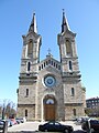
The Karlskirche ( Kaarli kirik ) consecrated in 1870
Tallinn City Hall across from Freedom Square ( Vabaduse väljak )

Street scene in Tõnismäe

Residential houses from the 1930s

Residential and commercial buildings

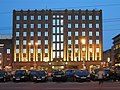
The luxury hotel "Palace" opened in 1937 (architect Elmar Lohk )

Historic water tower from the end of the 19th century


Web links
Individual evidence
- ↑ Archived copy ( Memento of the original from May 17, 2011 in the Internet Archive ) Info: The archive link was inserted automatically and has not yet been checked. Please check the original and archive link according to the instructions and then remove this notice.
- ↑ http://www.eelk.ee/~ktalkaarli/sulane/sulane8.html#ROBI
Coordinates: 59 ° 26 ' N , 24 ° 44' E
Haabersti : Astangu | Haabersti | Kakumäe | Mäeküla | Mustjõe | Õismäe | Pikaliiva | Rocca al Mare | Tiskre | Väike-Õismäe | Veskimetsa | Vismeistri
Kesklinn : Aegna | Juhkentali | Kadriorg | Kassisaba | Keldrimäe | Kitseküla | Compassi | Luite | Maakri | Mõigu | Raua | Sadama | Sibulaküla | South Alinn | Tatari | Tõnismäe | Torupilli | Ülemistejärve | Uus Maailm | Vanalinn | Veerenni
Kristiine : Järve | Lilleküla | Tondi
Lasnamäe : Katleri | Kurepõllu | Curisticsu | Laagna | Loopealse | Mustakivi | Pae | Paevälja | Priisle | Seli | Sikupilli | Sõjamäe | Tondiraba | Ülemiste | Uuslinn | Väo
Mustamäe : Kadaka | Mustamäe | Sowing | Siili
Nõmme : Hiiu | Kivimäe | Laagri | Liiva | Männiku | Nõmme | Pääsküla | Rahumäe | Raudalu | Vana Mustamäe
Pirita : Iru | Kloostrimetsa | Kose | Laiaküla | Lepiku | Maarjamäe | Mowing | Merivälja | Pirita
Põhja-Tallinn : Kalamaja | Karjamaa | Kelmiküla | Kopli | Merimetsa | Paljassaare | Pelgulinn | Pelguranna | Sitsi