Ziepel (Möckern)
|
Ziepel
City of Möckern
|
|
|---|---|
| Coordinates: 52 ° 8 ′ 59 ″ N , 11 ° 52 ′ 14 ″ E | |
| Height : | 65 m above sea level NHN |
| Area : | 29.81 km² |
| Residents : | 486 (December 31, 2018) |
| Population density : | 16 inhabitants / km² |
| Incorporation : | January 1, 2003 |
| Postal code : | 39291 |
| Primaries : | 039221, 039224 |
|
Aerial view of Ziepel
|
|
Ziepel is a town and part of Möckern in the Jerichower Land district in Saxony-Anhalt .
geography
The place is about seven kilometers west of Möckern. The district town of Burg is 25 kilometers north and the state capital Magdeburg is about 16 kilometers west of here. The district road K 1215, from which the B 246 can be reached, leads through Ziepel . The B 246, via which both Möckern and Magdeburg can be reached, passes about two kilometers to the south.
Ziepel station is on the Biederitz – Altengrabow railway line . The surrounding area is predominantly agricultural.
In terms of natural space , the place belongs to the Zerbster Land , an arable, open cultural landscape and 536 km² main unit of the superordinate main unit group of the Fläming in the north German lowlands . The Zerbster Land forms the southwestern roof of the Fläming to the Elbe and belongs to the catchment area of this river.
In addition to the district of Ziepel, the districts of Kampf and Landhaus belong to the village of the same name .
history
In a document from King Otto III. From the year 992 the place is mentioned for the first time with the name Sipli and is left to the monastery Memleben . The location at that time was about three kilometers north of today's town center. It was then probably desolate for a long time before Flemish immigrants founded the town of Dudendorf further south in the 12th century , which later took on the name Ziepel again via Czipell (1424), Ciepel (1459), Tzipel (1477) and Zcipel (1562). The first church in the village was built in the 13th century. The village was on the old Brandenburg – Magdeburg military road .
During the Thirty Years' War , mercenary troops raided the place on April 25, 1636 and completely destroyed it. The farms were only rebuilt thirty years later. Among other things, barley was grown here , which was delivered to the breweries in Burg.
In the course of the Prussian administrative reform, Ziepel was assigned to the district of Jerichow I with the district town of Burg in 1818 .
In 1847 Ziepel was listed in the "Topographical-Statistical Handbook of the Prussian State". The parish village included a Protestant church, a windmill, 34 houses and 220 souls.
In 1882 it was connected to the Biederitz – Altengrabow railway line. At that time Ziepel had about 370 inhabitants. The population increased after the Second World War , when many refugees from the lost German eastern territories settled here. When the GDR authorities dissolved the pre-war administrative structures in 1952, Ziepel came to the Burg district in the Magdeburg district. 1964 lived in the place 523 inhabitants. After the end of the GDR and another district reform, Ziepel found himself in the Jerichower Land district in 1994. On January 1, 2003 it was incorporated into the city of Möckern.
politics
The interests of the village of Ziepel in the city of Möckern are represented by the local council, which is made up of eight members and is headed by the local mayor, Wolfgang Koch.
Coat of arms: Blazon : “Diagonally left divided by green and silver; in it two oblique, three-leaf clovers in mixed up tinctures. ”The coat of arms was designed in 1996 by the municipal heraldist Jörg Mantzsch .
The town's flag is striped white - green (1: 1) (cross shape: stripes running horizontally, lengthways shape: stripes running vertically) and centered with the coat of arms.
Attractions
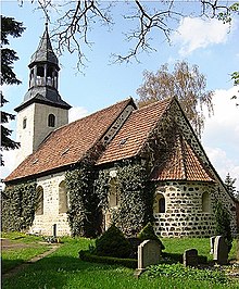
After Ziepel's first church was destroyed in 1636, the follow-up building, the St. Mark's Church, was completed in 1677. The original late Romanesque architectural style was largely preserved during the reconstruction . The square west tower was not added until 1735.
Web links
- Ziepel in the historical directory of the association for computer genealogy
- Ziepel village on the side of the town of Möckern
Individual evidence
- ↑ City of Möckern - Main Office (ed.): Development of the inhabitants in the districts and localities of the city of Möckern - Basis: City residents' registration file - as of December 31, 2018 . January 25, 2019.
- ↑ a b Main Statute of the City of Möckern in the version of September 25, 2014 - including 1st and 2nd amendment . June 1, 2018 ( full text [PDF; 115 kB ; accessed on December 28, 2018]).
- ↑ Map services of the Federal Agency for Nature Conservation ( information )
- ^ Eduard Messow : Topographical-statistical manual of the Prussian state . Second volume: L – Z. Publishing house by Emil Baensch, Magdeburg 1847, p. 455 ( digitized version in Google Book Search [accessed January 23, 2019]).
- ^ StBA: Changes in the municipalities in Germany, see 2003
- ↑ Wolfgang Koch. In: www.moeckern-flaeming.de. City of Möckern, accessed on September 30, 2019 .
- ↑ Jochen Roessle: The Romanesque village churches of the Magdeburg country - investigations of a design of the 12th and 13th centuries . University and State Library, Bonn 2006, Ziepel, p. 428 ff . ( hss.ulb.uni-bonn.de ( Memento from February 3, 2014 in the Internet Archive ) [PDF; 3.3 MB ; accessed on July 29, 2013] dissertation).


