Azara (Huesca)
| Azara municipality | ||
|---|---|---|
| coat of arms | Map of Spain | |

|
|
|
| Basic data | ||
| Autonomous Community : | Aragon | |
| Province : | Huesca | |
| Comarca : | Somontano de Barbastro | |
| Coordinates | 42 ° 4 ′ N , 0 ° 2 ′ W | |
| Height : | 429 msnm | |
| Area : | 14.49 km² | |
| Residents : | 171 (Jan 1, 2019) | |
| Population density : | 11.8 inhabitants / km² | |
| Postal code : | 22147 | |
| Municipality number ( INE ): | 22041 | |
Azara is a Spanish municipality in the province of Huesca in the autonomous community of Aragon . It is located in the Comarca Somontano de Barbastro , about 40 kilometers east of Huesca in the Valle de Alferche .
population
| 1900 | 1910 | 1930 | 1940 | 1950 | 1960 | 1970 | 1981 | 1986 | 1992 | 1999 | 2004 |
|---|---|---|---|---|---|---|---|---|---|---|---|
| 491 | 441 | 441 | 380 | 308 | 363 | 310 | 269 | 237 | 225 | 224 | 200 |
Attractions
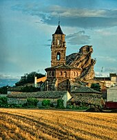
- Late Gothic church of Santa Lucía , built in the 16th century ( Bien de Interés Cultural )
- Remains of the Moorish castle on the rock of Santa Margarita
literature
- Huesca. Tourist guide of the Altoaragón. Editorial Pirineo, Huesca 2003, ISBN 84-87997-68-6 , p. 274.
Web links
Commons : Azara (Huesca) - Collection of images, videos and audio files
- Azara in CAI-Aragón (Spanish)
- Azara in the Comarca Somontano de Barbastro (Spanish, accessed February 9, 2014)
Individual evidence
- ↑ Cifras oficiales de población resultantes de la revisión del Padrón municipal a 1 de enero . Population statistics from the Instituto Nacional de Estadística (population update).


