
Brück (Dettelbach)
|
Bridge
City of Dettelbach
Coordinates: 49 ° 49 ′ 8 ″ N , 10 ° 9 ′ 3 ″ E
|
|
|---|---|
| Height : | 223 m |
| Residents : | 150 |
| Incorporation : | July 1, 1972 |
| Postal code : | 97337 |
| Area code : | 09324 |
 Location of Brück (bold) in the municipality of Dettelbach
|
|
 |
|
Brück is a district of the town of Dettelbach in the Bavarian district of Kitzingen in Lower Franconia . Until the voluntary merger with Dettelbach on July 1, 1972, Brück was an independent municipality. Historically, however, the village had been associated with Dettelbach for much longer. The city council of Dettelbach had the decision-making authority over the residents since 1484, who were also assigned to the office of Dettelbach in the Hochstift Würzburg.
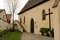
Today Brück is an agricultural place. However, in the past there were several vineyards in the district, with the Sonnenleite vineyard with its 5 hectares (1993) being a last remnant. The stone quarrying in several quarries around today's village was also significant. The center of Brück is the Catholic branch church of St. Jakobus, the tower of which has Romanesque remains.
Geographical location
Geography and natural structure
Brück is relatively centrally located in the Dettelbacher municipality and is therefore surrounded on all sides by Dettelbacher districts. Schnepfenbach is further to the north , while Neuses am Berg can be found in the northeast . The south is occupied by Dettelbach itself, whereby the former Dettelbacher town mills Küffleinsmühle, Lamprechtsmühle and Kieselsmühle (from north to south) connect the two places. Also between Brück and Schernau in the north-west is the Schernauer Mühle, a former mill.
The closest larger cities are Volkach , which is about eight kilometers away, and Kitzingen , which is about nine kilometers away. The next big city is Würzburg, about 16 kilometers away .
In terms of nature, Brück can be found in a valley basin within the so-called Gäuf area in the northern Maindreieck . This sub-unit is assigned to the over-main unit Gäuflächen in the main triangle of the Mainfränkische Platten . The landscape is characterized by its small brooks that flow towards the Main without forming deep notched valleys . It is characterized by extensive arable land.
The village lies in the Maingau climate zone , which is one of the driest and warmest in Germany. Brück is located on the Main tributary Dettelbach , also called Brücker Bach or Schnepfenbach. In the local area, the Schernauer Bach flows from the west into the Dettelbach, before the Schernauer Bach is reinforced by an unnamed body of water. Further north of the built-up area, the so-called Dietrichsgraben (also Gereutgraben in the upper reaches) flows into the Dettelbach.
Village structure

The Brücker district covers an area of 1.37 km². The center is the clustered village with the church in the north and a second, old part of the village in the south of the Schernauer Bach. For centuries, Brunnengasse was the center of village life. Small new building areas emerged in the 20th century only along the Dettelbach, which is now canalized in the local area, east and south-east of the village center. In 1984, further building areas with single or multi-family houses north and northwest of the church were advertised. The local cemetery was probably built here in the 20th century .
Due to the dense settlement along the stream valleys, Brück has only a very small area with a few named parcels . To the east of the village is the so-called Hämmerlein, which used to be planted with vines. The Brücker Holz area refers to a forest that used to be located here, but which disappeared in the course of extensive clearing around 1795 in favor of arable land. The last vineyards are now on the so-called Hofmannsberg or Jakobsberg in the north-northeast of the built-up area. There are no protected areas around Brück, only biotope areas are designated, especially along the Dettelbach.
history
Prehistory and early history
In contrast to the neighboring districts, only a few prehistoric and early historical finds have been made in the area of Brück . Only in the north-west and south-east of the village could two settlements be made out, so that it can be assumed that the area around the village was populated at an early stage. Through reading finds of broken glass, blade scratches and an eyelet, a settlement was made northwest of the church that had already been settled in the Neolithic Age.
Further finds document two settlements from the Hallstatt period , whereby the Neolithic site was continuously used. Ceramic remains from the 7th century BC were discovered. Some finds could be identified as storage vessels because they had the typical silt roughness. Other ceramic remnants were covered with a graphitization that had been applied to protect the material or as jewelry.
Due to population displacement during the migration period after the 4th century, the area around Brück was initially inhabited by Celts , who probably no longer left a permanent settlement here. They were later ousted by the Thuringians. Eventually the Franks reached the area around Dettelbach and established real administrative structures for the first time. This is how two royal courts were created in Prosselsheim and on the Vogelsburg . However, the Brück area initially remained uninhabited.
Middle Ages and Early Modern Times
The location of the village was crucial for its foundation. There two small footbridges led over the Dettelbach and the Schernauer Bach. The village with the meaningful place name originated around the year 700. It goes back to the advance of the immigrant Franks , who gradually settled this area in the early Middle Ages . During its history, Brück was always connected to the nearby town of Dettelbach, which later became a town .
However, Brück was first mentioned in the 14th century. Before the year 1321, the Lords of Hohenlohe were wealthy in Brück and even exercised lower jurisdiction over the residents. This share came in 1321 to Hans Ritter von Dettelbach, whose rights were strengthened with another document from 1357. Around 1450 the Benedictine monastery of St. Stephan from Würzburg received the goods of the knights.
Only a few decades later, however, the Würzburg prince-bishop rose to become the most powerful landlord in the Main Valley. Rudolf II von Scherenberg promoted the Dettelbach settlement in particular and elevated it to town in 1484. This upgrading was accompanied by the formation of a prince-bishop's office as the administrative seat. Brück and Schnepfenbach became the core of the Dettelbach office and remained closely linked to the city until the 19th century.
The connection with Dettelbach was also underlined by the inner-village organization. The Dettelbacher Council elected a so-called village master for Brück. He had to report to the Dettelbachers again and again and was bound by an oath to the council. The church was also part of the parish of Dettelbach. The Dettelbach city council and the prince-bishop's mayor also introduced the dimensions and weights for the village.
The proximity to Dettelbach also meant that the developments of the early modern period in Brück, similar to the neighboring city, came to fruition. During the Thirty Years' War the place suffered very similar destruction as the nearby city. Especially since the Swedish invasion in 1631, the population suffered from frequent billeting and pulling through. The war situation particularly damaged the local viticulture, which required intensive care.
Modern times
With the dissolution of the Würzburg bishopric through secularization at the beginning of the 19th century, the structures of the village initially changed little. As a royal Bavarian rural community , they still counted themselves in the district of Dettelbach, which has now been renamed the district court. Only with the decline of viticulture due to the conversion of feudal management did a deep break occur. In 1892 the community purchased a grapevine syringe to combat phylloxera infestation on the vines . Fruit growing became the successor to viticulture.
During the First World War a total of three men from Brück died at the front. A memorial was erected to them in 1938, and in 1972 the 19 dead of World War II were added. During the National Socialism, many prisoners of war, especially French, had to toil in the fields in Brück. At the same time, the community took in many bombed out and evacuated people from the Saarland and the Ruhr area . Before the Americans marched in on April 7, 1945, some women from Brücker removed the anti-tank barriers at the entrance to the village.
After the war, the town experienced great population growth due to the influx of refugees from the former German areas. In 1947 there was a bad harvest . The asphalting of the municipal roads began in 1951, and in 1963 the town was connected to the Franconian long-distance water supply. After the first plans to merge the towns of Brück, Neusetz and Schnepfenbach had already failed in 1919 due to the opposition of the municipalities, Brück became part of the larger municipality of Dettelbach in 1972 as part of the regional reform .
Place name
The place name Brück refers to the early function of the place, which connected (virtually bridged) the two central places Dettelbach and Prosselsheim with its two footbridges over the small brooks. The name has hardly changed in the past. Brückh is mentioned in a document from the 18th century.
Administration and courts
|
The following administrative units were superordinate to the municipality of Brück.
|
Brück was judicially subject to the following instances.
|
politics
From village master to local spokesman
For centuries the village community was headed by a so-called village master who, however, was bound by instructions from the authorities . He was installed by the council of the city of Dettelbach and the prince-bishop's mayor in Dettelbach and represented their positions in the village. Unlike in many other places in the area, Brück did not appoint a separate mayor, who was a kind of direct representative of the prince-bishop .
With the secularization, the mayor of Dettelbach soon fell away and the village community decided independently over the so-called head of the community. It is noteworthy that the surname Dorsch for one of the village masters has been passed down from the 17th century. The Dorsch family provided the head twice, and even after the office was renamed mayor, the local board often consisted of members of the family.
| List of Mayors of Brück (selection) | |||||||
|---|---|---|---|---|---|---|---|
| Surname | Term of office | Remarks | |||||
| Georg Dorsch | 1900-1912 | ||||||
| Franz Strauss | 1912-1923 | ||||||
| Johann Walter | 1923-1933 | 1st term of office, honorary citizen | |||||
| Josef Dorsch | 1933 | ||||||
| Hans Gaub | 1933-1934 | ||||||
| Georg Holzapfel | 1935-1945 | ||||||
| Johann Walter | 1945-1946 | 2nd term, appointed by the American military government, honorary citizen | |||||
| Ludwig Gerhard | 1946-1957 | " Former Mayor ", honorary citizen | |||||
| Franz Falkenstein | 1957-1966 | ||||||
| Albin Dorsch | 1966-1972 | at the same time also the first local spokesman for Brück | |||||
In the 20th century, the election of mayors became more and more standardized and became a normal part of the democratic decision-making process. In 1957 there had to be three elections before Franz Falkenstein was chosen as the successor to Ludwig Gerhard as mayor . After the incorporation in Dettelbach, local spokesmen and / or city councilors represented the bridge in the city council of Dettelbach. In addition to Albin Dorsch, these were Franz Stengl, Winfried Nöller, Hans Rummey and the Second Mayor Herbert Holzapfel.
Population development
Today Brück is one of the smaller districts of Dettelbach. Population figures for the place have been handed down from the 16th century, although only estimates based on the verifiable family heads are available here . At that time around 100 people lived in Brück. The population grew steadily until the Thirty Years War drastically reduced the population. In the first half of the 19th century, when concrete population figures were handed down, the values before the war were exceeded again.
In the second half of the 19th century, the place began to shrink, probably due to the decline in viticulture. After the Second World War, Brück benefited from the influx of refugees, the all-time high of 277 inhabitants can be traced back to this development. In the period that followed, the village shrank again, particularly due to the rural exodus . In 1996 the village was very overweight men, especially in the 30 to 39 year old group.
| year | Residents | year | Residents | year | Residents |
|---|---|---|---|---|---|
| 1574 | at 100 | 1885 | 202 | 1961 | 213 |
| around 1622 | at 153 | 1900 | 157 | 1970 | 215 |
| 1824 | 185 | 1933 | 207 | 1987 | 163 |
| 1855 | 246 | 1946 | 277 | 1993 | 154 |
Culture and sights
Architectural monuments
James Church

The center of the village is the Catholic branch church St. Jakobus. It is one of the older places of worship in the area; a small chapel with a Romanesque choir tower was built in the village as early as the 12th century . The remains of this tower are built into today's successor building. The existing nave was built in the 17th century, and in 1846 it was expanded after the community grew.
Today the church presents itself as a simple hall structure . The nave has four window axes. The oldest part of the church is the tower, which was placed south of the choir . The upper floor is made of half-timbering and was subsequently covered with slate panels. The tower ends with a pointed helmet. A church clock was installed on the east side. The church has had several different patronages throughout its history.
Inside, the furnishings of the 17th century predominate, especially the two splendid side altars from this period. Both altars have two twisted columns and were decorated with a broken gable and rich fruit hangings. Several figures were placed in the church. In the head of the choir there is a figure of Our Lady in a halo . It was created in the 18th century. The other works of art inside were made by regionally known artists such as the Schiestl brothers .
Wayside shrines and small memorials
A total of two wayside shrines in the Brück district are still listed as monuments today. They are typical of a Catholic village in Main Franconia . However, their numbers were still much higher in the 1970s. During the inventory of the wayside shrines, a total of six tortures were identified, whereby the wayside shrine did not appear on the so-called stone fields in this list. The number of wayside shrines continues to shrink today, particularly due to damage and destruction.
The oldest surviving stick is a torture column in front of the church. The wayside shrine was probably located at the exit to Dettelbach before 1970, where a pedestal could still be found for a long time. It is about 2.75 m high and presents the representation of the Pietà in its essay . In front of it is a kneeling donor figure. The inscription refers to the donor couple: "andreas dhorsch and his married house wife urschala anno 1720".
The second wayside shrine in the north of the village on State Road 2270 is much younger. It goes back to a foundation in 1897 and also presents a Vesper picture in its essay. The wayside shrine may be the remains of a field altar that reminds of the death of a Oberpleichfeld field at this point. On November 10th, 1897, Johann Georg Brändler had an accident while hauling stones. The altar was destroyed in the 1960s. In August 2019, the stick could no longer be found.

James statue at the church
Church portal

Wayside shrine Lindenbergweg 1


Village mill
| inscription |
| This house is in the hands of the gentleman , it is called Briicker Mühl. Built by Veit Stolzenberger and his wife in 1614 |
The Brücker Dorfmühle was for a long time the largest secular building in town. It was located in house no. 13 (today Am Kirchberg 5) and was an important economic factor for Brück from the 16th to the 20th century. Nothing is known about the early days of the mill. It was not until 1544 that it was first indirectly known as a mill " on the Brückerbach in the village of Brück ”. The mill probably first belonged to Count Wolfgang I. zu Castell and then it came to the Würzburg Monastery through an exchange for the Trautberger Schafhof .
In 1574 a document reported about the mill. It is said to have originally belonged to Hermann von Seinsheim . He sold the plant to Würzburg, so that by 1574 at the latest, the Brücker mill “is subordinate to the Prince-Bishop of Würzburg with all the submission, including all taxes.” From then on, the mill was also part of the Dettelbach office. A mill order from 1638 described them in more detail. The Brücker Mühle was used as a flour mill, but it was also used to extract grist .
Although the mill was in noble hands, the bishopric used so-called possesors, later tenants , who were supposed to keep the business going . In 1544, Augustin Bauroth owned the Brücker Mühle, bought it from Veit Stolzenberger. In the course of secularization , the mill was virtually privatized. In 1840 Michael Leimeister was the owner of the Brücker Mühle, in 1890 Georg Döppler and his wife Anna Eva, née Otto, bought the facility.
The Brücker mill was powered by two grinding cycles , but by the 20th century it was no longer profitable. The last miller, Anton Döppler, only operated the grist mill as a sideline . In the 1950s he gave up the operation of the mill. The mill house with its saddle roof pulled down a few years and was demolished in the 1960s. Only an inscription stone from 1614 was saved and built into the subsequent building.
Economy and Infrastructure
economy
Viticulture
Today Brück is a wine-growing area in the Franconian wine-growing region . However, it does not have its own vineyard ; the wine has been marketed under the name Dettelbacher Sonnenleite since the 1970s. Bridging is part of the range Volkacher Main loop until 2017, the wineries in area were Maindreieck summarized. The shell limestone and Lettenkeup soils around Brück are also suitable for growing wine, as is the location in the Maingau climate zone, which is one of the warmest in Germany.
The people around Brück have been cultivating wine since the early Middle Ages . The Franconian settlers probably brought the vine to the Main in the 7th century. In the Middle Ages, the region was part of the largest contiguous wine-growing region in the Holy Roman Empire. The people mostly operated part-time viticulture for self-sufficiency , at the same time export centers were already emerging, especially along the Main. In Brück, wine growing was mostly a matter for the respective households.
Viticulture experienced a major decline after secularization at the beginning of the 19th century. Above all, locations with less favorable climatic conditions were completely abandoned. In addition, the emergence of pests such as phylloxera made cultivation difficult . The Franconian wine-growing region was not able to consolidate again until the second half of the 20th century. The use of fertilizers and improved cultivation methods had contributed to this, as had the organization in cooperatives and the land consolidation of the 1970s.
| Vineyard | Size 1980 | Size 1993 | Compass direction | Slope | Main grape varieties | Great location |
|---|---|---|---|---|---|---|
| Sonnenleit | 1 ha | 5 ha | south | 30% | Müller-Thurgau | Dettelbacher Honigberg |
Other branches of industry
For centuries, Brück was shaped by its quarries . The first fractures around the village can be documented as early as around 1600. In addition to building the road, the stones from Brück were also used to build the church of St. Peter and Paul in Oberpleichfeld. At times there was even a track in the tunnels with a trolley transport, while horses were used to remove the pieces. A total of three quarries were exploited that ran along the streams. Stone mining in Brück ended around 1950.
Today the people in Brück live mainly from agriculture with conventional products. Fruit growing , which was revived for a short time, declined again in the 20th century after a short bloom. Livestock farming no longer plays a major role either. Due to its location near Dettelbach, Brück is also a typical out- commuter community today . People go to industrial plants in Dettelbach, Kitzingen or Würzburg.
traffic

Brück is rather insignificant in terms of traffic today. The most important traffic connection is the state road 2270, which runs from north to south in the village as St.-Markus-Straße. The place name Brück, however, refers to the important function that the settlement had during the Middle Ages and the early modern period. Here there was a bridge over the Dettelbach and the Schernauer Bach, which made Brück into a kind of bottleneck between the prince-bishop's offices in Dettelbach and Prosselsheim .
From 1923 to 1929 two new bridges were built in the course of the land consolidation , at which point only agricultural traffic still used Brück as a transit station. It was not until 1951 that the main road in Brücker was paved ; in the following years, the other village roads were also paved. This work was completed in 1970 and the Brunnengasse, Krautackersweg and Obere Schulgasse were finally expanded.
In addition to the main road just yet is still owned county road KT 7 on local traffic importance. Coming north of Schernau, it flows into the state road on the Brücker district. An OVF bus line goes to the place several times a day, it is the line 8108 ( Nordheim –Dettelbach– Rottendorf –Würzburg). Two stops (Brück and Abzw. Brück) are approached by the buses located on the state road and on the district road.
education
Not much is known about the school situation in Brück during the early modern period. A new school building was built in 1852 and was sold to private individuals when the new fire station was built. Before 1852, classes were held in various private houses, including in today's streets at Hirtenbühl and in Kirchgasse. In the 19th century, the Schnepfenbachers also attended the Brücker school. For centuries, early childhood education and care were taken over by members of the families who were used as " child maids " during the day .
The small elementary school was closed in 1969 and Brück joined the larger Dettelbach school association . Today, Brück, like all the districts of Dettelbach, is part of the Dettelbach primary school district. The place was also assigned to the Dettelbach secondary school district. Further education is provided by the Staatliche Realschule Dettelbach. High schools can be found in Volkach ( Franken-Landschulheim Schloss Gaibach ), Schwarzach ( Egbert-Gymnasium Münsterschwarzach ) and Kitzingen ( Armin-Knab-Gymnasium ).
Associations and associations

Despite its small size, Brück has a large number of clubs and associations. By far the oldest existing organization is the Brück Voluntary Fire Brigade , which is now supported by a fire brigade association. The community acquired a fire escape as early as 1855. However, the weir was not officially founded until December 28, 1876, following a request from the Bavarian Municipal Council. In 1887 a compulsory fire brigade was established for a time .
In the 1990s, the Brück fire brigade was given a new location for their meetings. For this purpose, the community sold the former school and town hall. On May 28, 1995, the new fire station on St.-Markus-Strasse and the corner of Am Viehgraben was inaugurated. The Wehr has a special rarity with a suction and pressure spray trolley from 1876, which is presented on festive occasions. The equipment for fire operations consists of a portable pump vehicle (TSF). Acting commander is Daniel Ruß.
Already in 1593 were seven of the community first mentioned. They had to take an oath to the city council of Dettelbach and were then responsible for surveying the parcels. The sevens from Brück no longer appear in Dettelbach's club directory, and their work may have had to be stopped due to a lack of members. In 1996 Otmar Holzapfel was listed as local chairman, six other men formed the seventh.
Other clubs in Brück in alphabetical order (clubs that no longer exist were marked with a †): The Brück and Schnepfenbach Hunting Association, the youth initiative "Brügger Jugend", the music band (†), the Brück fruit and horticultural association with the children's and The “Glückskäfer” youth group, the cycling association (†), the Brück soldiers and warriors and the Brück savings and loan association (†).
Personalities
Only a few personalities, also well-known nationwide, worked in the small town. The officials of Dettelbach certainly exerted influence in the associated village. The independent municipality of Brück named two honorary citizens before it was dissolved in 1972. On November 10, 1946, the former mayor Johann Walter received honorary citizenship on the day of his golden wedding anniversary. He had during the Great Depression led the fortunes of the community and was appointed the first mayor after the Second World War by the Americans.
Another mayor, Ludwig Gerhard, received honorary citizenship in 1957. On December 20, 1957, in the presence of District Administrator Oskar Schad, he was granted honorary citizenship. Gerhard held the post of mayor from 1946 and made a decisive contribution to the reconstruction of the post-war period . Gerhard also received the honorary title of " Former Mayor ".
literature
Literature on Brück
- Hans Bauer: "Brück - a village near Dettelbach" . In: Yearbook of the district of Kitzingen 1980. In the spell of the Schwanberg . Pp. 118-120.
- Hans Bauer: Brücker village life in 1612 . In: City of Dettelbach (ed.): Brück. A village introduces itself. A village, its people, associations and customs . Brück 1996. pp. 7-11.
- Hans Bauer: School conditions in Brück, Neusetz and Schnepfenbach in 1904 (= Dettelbacher Geschichtsblätter 1985) . Dettelbach 1985.
- Dieter Ehrbar: Chronicle of the volunteer fire brigade Brück . In: City of Dettelbach (ed.): Brück. A village introduces itself. A village, its people, associations and customs . Brück 1996. pp. 104-111.
- Leo Krammel: The Brunnengasse . In: City of Dettelbach (ed.): Brück. A village introduces itself. A village, its people, associations and customs . Brück 1996. pp. 44-48.
- Josef Mack: Brücker citizens tell stories . In: City of Dettelbach (ed.): Brück. A village introduces itself. A village, its people, associations and customs . Brück 1996. pp. 93-96.
- Josef Mack: The Brücker field jury . In: City of Dettelbach (ed.): Brück. A village introduces itself. A village, its people, associations and customs . Brück 1996. pp. 112-115.
- Armin Mosandl: From the history of the Brück district 1900–1984 . In: City of Dettelbach (Ed.): Dettelbach. 1484-1984. Festschrift and small characteristics of a 500 year old city . Dettelbach 1984. pp. 265-269.
- Armin Mosandl: The Mill Bridge . In: City of Dettelbach (ed.): Brück. A village introduces itself. A village, its people, associations and customs . Brück 1996. pp. 35-39.
- Winfried Nöller: The Church of St. Jakobus in Brück . In: City of Dettelbach (ed.): Brück. A village introduces itself. A village, its people, associations and customs . Brück 1996. pp. 23-33.
- Hans Rummey: The inhabitants of Brück 1924-1996 . In: City of Dettelbach (ed.): Brück. A village introduces itself. A village, its people, associations and customs . Brück 1996. pp. 12-15.
- Hans Rummey: guilt Hot, superintendent, mayor ... . In: City of Dettelbach (ed.): Brück. A village introduces itself. A village, its people, associations and customs . Brück 1996. pp. 16-22.
- Hans Rummey, Peter Schöderlein: Settlements around Brück during the Hallstatt period . In: City of Dettelbach (ed.): Brück. A village introduces itself. A village, its people, associations and customs . Brück 1996. pp. 132-133.
Other literature used
- Hans Ambrosi, Bernhard Breuer: German Vinothek: Franconia. Guide to the vineyards, winegrowers and their kitchens . Herford 2 1993.
- Hans Bauer: Dettelbach as the administrative headquarters and central location . In: City of Dettelbach (Ed.): Dettelbach. 1484-1984. Festschrift and small characteristics of a 500 year old city . Dettelbach 1984. pp. 37-39.
- Hans Bauer: The history of viticulture in Dettelbach . In: City of Dettelbach (Ed.): Dettelbach. 1484-1984. Festschrift and small characteristics of a 500 year old city . Dettelbach 1984. pp. 116-122.
- Hans Bauer: The cultural landscape development of the old Dettelbach office since the 16th century (= Mainfränkische Studien Volume 17 / I). Diss . Wuerzburg 1977.
- Hans Bauer: District of Kitzingen. An art and culture guide . Market wide 1993.
Web links
Individual evidence
- ^ Bauer, Hans: Dettelbach . P. 219.
- ^ Krammel, Leo: The Brunnengasse . P. 44.
- ↑ Rummey, Hans: settlements around bridge during the Hallstatt period . P. 133.
- ↑ Nöller, Winfried: The Church of St. Jakobus in Brück . P. 26.
- ^ Bauer, Hans: "Brück - a village, located near Dettelbach" . P. 118.
- ^ Bauer, Hans: "Brück - a village, located near Dettelbach" . P. 120.
- ^ Bauer, Hans: The cultural landscape development of the old office Dettelbach . P. 81 f.
- ^ Bauer, Hans: "Brück - a village, located near Dettelbach" . P. 119.
- ↑ Ungemach, Gretel: War and post-war period . P. 81.
- ^ Bauer, Hans: The district of Kitzingen . P. 32.
- ↑ Rummey, Hans: guilt Hot, superintendent, mayor, municipal, city councils and local speakers . Pp. 17-19.
- ↑ Rummey, Hans: The inhabitants of Brück 1924-1996 . P. 15.
- ↑ Bavarian State Statistical Office (ed.): Official city directory for Bavaria, territorial status on October 1, 1964 with statistical information from the 1961 census . Issue 260 of the articles on Bavaria's statistics. Munich 1964, DNB 453660959 , Section II, Sp. 881 ( digitized version ).
- ^ Bavarian State Statistical Office (ed.): Official place directory for Bavaria . Issue 335 of the articles on Bavaria's statistics. Munich 1973, DNB 740801384 , p. 188 ( digitized version ).
- ^ Bauer, Hans: Dettelbach . P. 222.
- ↑ Bavarian State Office for Statistics and Data Processing (Ed.): Official local directory for Bavaria, territorial status: May 25, 1987 . Issue 450 of the articles on Bavaria's statistics. Munich November 1991, DNB 94240937X , p. 364 ( digitized version ).
- ↑ Bavarian State Statistical Office (Hrsg.): Historical municipality register: The population of the municipalities of Bavaria in the period from 1840 to 1952 (= contributions to Statistics Bavaria . Issue 192). Munich 1954, DNB 451478568 , p. 205 , urn : nbn: de: bvb: 12-bsb00066439-3 ( digitized version ).
- ↑ Rummey, Hans: The inhabitants of Brück 1924-1996 . P. 13.
- ^ Cf.: Nöller, Winfried: The Church of St. Jakobus in Brück . Pp. 23-33.
- ^ Bauer, Hans: Brücker wayside shrines - then and now . P. 40.
- ^ Bauer, Hans: Brücker wayside shrines - then and now . P. 41.
- ↑ Eberle, Anton: The twelve mills in Dettelbach . P. 120.
- ^ Bauer, Hans: Dettelbach . P. 222.
- ↑ Mägerlein, Fritz: The mills in Kitzinger country in 1840 . P. 116.
- ↑ Mosandl, Armin: The Mühle . P. 39.
- ^ Ambrosi, Hans (among others): German Vinothek: Franconia . Pp. 50-52.
- ^ Government of Lower Franconia: Vineyards in Bavaria broken down by area , PDF file, accessed on May 16, 2019.
- ^ Bauer, Hans: The history of viticulture in Dettelbach . P. 120.
- ^ Ambrosi, Hans (among others): German Vinothek: Franconia . P. 237.
- ^ Krammel, Leo: Brück quarries . P. 97.
- ↑ Mosandl, Armin: From the history of the district Brück 1900-1984 . P. 266.
- ↑ Mack, Josef: Brücker citizens tell . P. 94.
- ↑ Ehrbar, Dieter: Chronicle of the volunteer fire brigade Brück . P. 105.
- ↑ KFV-Kitzingen: Brück Voluntary Fire Brigade , accessed on August 26, 2019.
- ↑ Mack, Josef: The Brücker Feldgeschworen . P. 115.

Bibergau | Bridge | Dettelbach | Dettelbach train station | Effeldorf | Euerfeld | Mainsondheim | Neuhof | Neuses am Berg | New set | Schernau | Schnepfenbach | Sulzhof