
Gessertshausen
| coat of arms | Germany map | |
|---|---|---|

|
Coordinates: 48 ° 20 ' N , 10 ° 44' E |
|
| Basic data | ||
| State : | Bavaria | |
| Administrative region : | Swabia | |
| County : | augsburg | |
| Management Community : | Gessertshausen | |
| Height : | 478 m above sea level NHN | |
| Area : | 41.35 km 2 | |
| Residents: | 4362 (Dec. 31, 2019) | |
| Population density : | 106 inhabitants per km 2 | |
| Postal code : | 86459 | |
| Area code : | 08238 | |
| License plate : | A , SMÜ, WHO | |
| Community key : | 09 7 72 148 | |
| LOCODE : | DE XGH | |
| Community structure: | 9 parts of the community | |
| Address of the municipal administration: |
Hauptstrasse 31 86459 Gessertshausen |
|
| Website : | ||
| Mayor : | Jürgen Mögele ( CSU ) | |
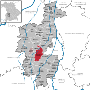
| Location of the community of Gessertshausen in the Augsburg district | ||
  |
||

Gessertshausen is a municipality in the Swabian district of Augsburg and the seat of the Gessertshausen administrative community . The community of Gessertshausen is largely shaped by the recreational area of the Schmutter and Schwarzach valleys. The Schmuttertal is now a designated FFH area with Europe-wide importance. A big draw in the vicinity is the Oberschönenfeld Monastery , a Cistercian monastery that was founded in 1211. The Oberschönenfeld Museum is located in the former farm buildings . Gessertshausen is located in the Augsburg - Western Woods Nature Park , an area of 1200 km² west of Augsburg . The area is of great importance for the region, especially for those looking for relaxation, but also as a supplier of wood.
geography
location
The main town of Gessertshausen is about 15 kilometers west of Augsburg on the Schmutter and in the Augsburg-Westliche Wälder nature reserve .
Landscapes and parts of the municipality
The municipality consists of five districts and has nine officially named municipal parts (non-officially named districts are in italics ):
- Main town, parish village and district Gessertshausen with the hamlet of Dietkirch, the Hubertus chapel , the Oberschönenfeld monastery and the desert mountain mill
- Kirchdorf and district Deubach with the wasteland Deubacher Mühle
- Parish village and district Döpshofen with the village Weiherhof and the hamlet Engelshof
- Kirchdorf and district Margertshausen
- Kirchdorf and district Wollishausen
Gessertshausen
The district of Gessertshausen also includes the monastery settlement Oberschönenfeld, the hamlet Dietkirch with parish church and the solitude of Engelshof. The place name "Gotsherhusen" appears in a document for the first time around the year 1150. Gessertshausen is one of the first settlements in the Schmuttertal and is considered the starting point for settlement in the area. In the Middle Ages, the Augsburg episcopal possessions in Gessertshausen were given as fiefs to various citizens of Augsburg, including Sieboto Schongauer. Through donations and purchases, all of these possessions gradually passed to the Oberschönenfeld monastery, which exercised the manorial power until secularization .
Originally on an island, now on the Schmutter, is the regionally important baptistery in Dietkirch; the current church building dates from 1723 and is the work of the South Tyrolean master builder Franz Beer . In the valley of the Schwarzach, southwest of Gessertshausen, lies the Cistercian convent Oberschönenfeld. In addition to the art-historically remarkable monastery church by Franz Beer, the entire monastery complex in its original form is unique in the whole of Germany.
In the middle of the woods south of Gessertshausen is the solitude of Engelshof, which was probably created by clearing in the eleventh century and purchased in 1151 from the Augustinian canons of St. Georg in Augsburg. The small castle estate was used by the canons as a summer residence until secularization, and the Michael's Chapel, built there in 1613, was demolished in 1834.
Margertshausen
On the right bank of the Schmutter, 17 km southwest of Augsburg, lies the former independent municipality of Margertshausen. There was already a settlement there in the 10th century, but the place itself is likely to have originated in the 8th or 9th century. "Madelgershausen" was first mentioned in a document around 1140. Margertshausen belonged to the hospital built by Bishop Ulrich von Augsburg and in the 12th century passed to the Augustinian canon monastery Heilig Kreuz , which exercised the manorial rule until secularization.
history
Until the church is planted

Gessertshausen is one of the first branches in Schmuttertal and is seen as the starting point for settlement in the area. The place "Gotsherhusen" is first mentioned around the year 1150.
In the Middle Ages, the Augsburg episcopal possessions from Gessertshausen were lent to various Augsburg citizens as fiefs. Through donations and purchases, all of these possessions gradually passed to the Oberschönenfeld monastery, which ruled the land until the secularization of 1803. Since secularization, Gessertshausen has been Bavarian due to the Reichsdeputationshauptschluss .
Population development
Between 1988 and 2018 the municipality grew from 3,871 to 4,344 by 473 inhabitants or by 12.2%.
Incorporations
On July 1, 1972, the previously independent communities Gessertshausen, Margertshausen and Wollishausen were merged to form the new community Gessertshausen. Deubach and Döpshofen were added on May 1, 1978.
politics
Due to the local election on March 15, 2020 , the local council is composed as follows:
- CSU : 7 seats (43.5%)
- Greens / ÖDP : 4 seats (25.4%)
- Free electoral association : 3 seats (18.8%)
- SPD : 2 seats (12.3%)
Compared to the 2014 to 2020 term of office, the CSU and SPD each lost one seat, the Free Voters' Association remained unchanged, and the Greens (2020 together with the ÖDP) gained two seats.
Jürgen Mögele (CSU) has been mayor since November 4, 2016.
coat of arms
|
|
Blazon : "On a shield diagonally divided by red and silver, a standing, gold-crowned and nimbled Madonna in a blue cloak and red undergarment, the child on the right arm, holding a rose branch in the left."
Note: From a heraldic point of view, strictly speaking, it should read: "On a shield that is diagonally divided by silver and red", since the upper color is mentioned first in the case of a diagonal division. Here the official blazon differs from the usual heraldic practice. |
Culture and sights
Architectural monuments
Economy and Infrastructure
traffic
Public transport
Gessertshausen is conveniently located on the Augsburg – Ulm railway line . On September 26, 1853, the Augsburg - Dinkelscherben section of the Bavarian Maximiliansbahn was opened and a station was built on this line in Gessertshausen . On May 1, 1854, the entire Maximiliansbahn line from Ulm to Munich was finally completed.
From October 12, 1910 to February 8, 1912, the Staudenbahn branching off from the Maximiliansbahn from Gessertshausen via Markt Wald and Ettringen to Türkheim was opened in several sections, making Gessertshausen a railway junction . On September 24, 1982, passenger traffic was stopped on the section from Markt Wald to Ettringen and freight traffic on May 28, 1983 due to the poor state of the superstructure , and the section was closed. On May 31, 1991 the passenger traffic between Gessertshausen and Markt Wald and on May 1, 1996 the freight traffic between Fischach and Markt Wald was stopped. On July 28, 2001, however, the line to Langenneufnach and on May 1, 2003 to Markt Wald was reopened. It is operated by Stauden-Verkehrs-GmbH for freight and excursion traffic, which offers excursion trains every second Sunday between Gessertshausen and Markt Wald. The route can only be reached via platform 1 of the newly built, double-track Gessertshausen station.
Today the Fugger-Express runs on the main line Ulm – Munich , which runs every hour as a regional express from Ulm to Munich and as a regional train from Dinkelscherben to Munich, so that there is a half-hourly service between Dinkelscherben and Munich.
There is a free park-and-ride space at Gessertshausen train station .
There are several bus stops in the community of Gessertshausen, which are served by the following lines of the Augsburg Transport Association :
- Line 600: Augsburg Hbf - Gessertshausen Hauptstr. - Gessertshausen train station - Wollishausen B 300 - Krumbach
- Line 601: Augsburg Hbf - Gessertshausen Hauptstr. - Dietkirch - Wollishausen place - Fischach
- Line 602: Gessertshausen train station - Deubach fire station - Deubach church - Deubach Willishauser Str. - Diedorf train station
- Line 604: Gessertshausen train station - Gessertshausen Oberschönenfelder Str. - Margertshausen train station - Margertshausen town center - Fischach - Wollmetshofen - Langenneufnach - Mittelneufnach - Markt Wald
- Line 605: Gessertshausen train station - Gessertshausen Oberschönenfelder Str. - Oberschönenfeld - Weiherhof - Döpshofen Weidenstrasse. - Döpshofen town center - Mickhausen
- Line 606: Gessertshausen train station - Dietkirch - Wollishausen Ort - Mickhausen - Schwabmünchen train station
- Line 607: Gessertshausen train station - Dietkirch - Wollishausen Ort - Münster
Private transport
Gessertshausen's main thoroughfare is the federal highway 300 (section Memmingen - Augsburg). The St2026 also begins in Gessertshausen and connects to Bundesstraße 16 as a cross connection to Hausen (in the municipality of Pfaffenhausen) .
school
- Gessertshausen primary school
Sons and daughters of Gessertshausen
- Joseph Dossenberger (1721–1785), master builder
- Max Strehle (* 1946), Member of the Bavarian State Parliament (CSU)
Web links
- Local government
- Gessertshausen: Official statistics of the LfStat (PDF; 1.2 MB)
Individual evidence
- ↑ "Data 2" sheet, Statistical Report A1200C 202041 Population of the municipalities, districts and administrative districts 1st quarter 2020 (population based on the 2011 census) ( help ).
- ^ Community Gessertshausen in the local database of the Bayerische Landesbibliothek Online . Bavarian State Library, accessed on August 20, 2019.
- ^ Wilhelm Volkert (ed.): Handbook of Bavarian offices, communities and courts 1799–1980 . CH Beck, Munich 1983, ISBN 3-406-09669-7 , p. 424 .
- ^ Federal Statistical Office (ed.): Historical municipality directory for the Federal Republic of Germany. Name, border and key number changes in municipalities, counties and administrative districts from May 27, 1970 to December 31, 1982 . W. Kohlhammer, Stuttgart / Mainz 1983, ISBN 3-17-003263-1 , p. 768 .
- ^ Greetings from the 1st Mayor. Community of Gessertshausen, accessed on July 23, 2020 .
- ^ Entry on the Gessertshausen coat of arms in the database of the House of Bavarian History
Deubach with Deubacher Mühle | Döpshofen with Engelshof and Weiherhof | Gessertshausen with Bergmühle, Dietkirch, Hubertuskapelle and Oberschönenfeld | Margertshausen | Wollishausen

Adelsried | Allmannshofen | Altenmünster | Aystetten | Biberbach | Bobingen | Bonstetten | Diedorf | Spelled shards | Ehingen | Ellgau | Emersacker | Fischach | Gablingen | Gersthofen | Gessertshausen | Dig | Großaitingen | Heretsried | Hiltenfingen | Horgau | Kleinaitingen | Klosterlechfeld | Koenigsbrunn | Kühlenthal | Kutzenhausen | Langenneufnach | Langerringen | Langweid am Lech | Meitingen | Mickhausen | Mittelneufnach | Neusäß | Nordendorf | Oberottmarshausen | Scherstetten | Schwabmünchen | Stadtbergen | Heads of animals | Untermeitingen | Ustersbach | Walkertshofen | Wehringen | Welden | Westendorf | Zusmarshausen
Unregulated areas: Schmellerforst