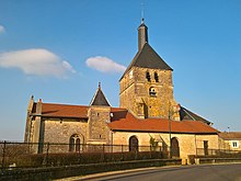
Dommartin-le-Franc
| Dommartin-le-Franc | ||
|---|---|---|
|
|
||
| region | Grand Est | |
| Department | Haute-Marne | |
| Arrondissement | Saint-Dizier | |
| Canton | Wassy | |
| Community association | Saint-Dizier, Der et Blaise | |
| Coordinates | 48 ° 26 ' N , 4 ° 58' E | |
| height | 187-279 m | |
| surface | 10.03 km 2 | |
| Residents | 248 (January 1, 2017) | |
| Population density | 25 inhabitants / km 2 | |
| Post Code | 52110 | |
| INSEE code | 52171 | |
 Entrance |
||
Dommartin-le-Franc is a French commune with 248 inhabitants (as of January 1, 2017) in the Haute-Marne department in the Grand Est region (until 2015 Champagne-Ardenne ). The municipality belongs to the arrondissement of Saint-Dizier and to the municipal association of Saint-Dizier, Der et Blaise, founded in 2016 . The residents call themselves Dommartinois .
geography
The municipality of Dommartin-le-Franc is located 23 kilometers south of the arrondissement capital of Saint-Dizier . The 10.03 km² large municipality of Dommartin-le-Franc includes a section of the Blaise , which divides here into two river arms. The municipality extends to the southeast about 1500 m on an agricultural plateau, west of the Blaise, the municipality extends about two kilometers over the forest of Les Arpents , which is part of the 60 km² forest area Forêt du Der . In the southeast of the municipality, the highest point is reached in the La Fortelle forest at 279 m above sea level.
Neighboring municipalities to Dommartin-le-Franc are (clockwise, starting from the north): Ville-en-Blasiois , Morancourt , Baudrecourt , Courcelles-sur-Blaise , Dommartin-le-Saint-Père and Bailly-aux-Forges .
Population development
In 1881 the population of the community reached its highest level to date with 585 residents.
| year | 1962 | 1968 | 1975 | 1982 | 1990 | 1999 | 2005 | 2016 | |
|---|---|---|---|---|---|---|---|---|---|
| Residents | 327 | 319 | 333 | 312 | 273 | 258 | 228 | 246 | |
| Sources: Cassini and INSEE | |||||||||
Attractions
The nave of the parish church of Saint-Martin probably dates from the 11th century. Two engraved dates in a niche and on a door (1546 and 1559) suggest ombuds in the 16th century. The bell tower also seems to come from this period.
There are two old iron foundries in Dommartin. They have been turned into a “metallurgy park” and, together with an old blacksmith's shop, have been turned into an arts and crafts center ( Fonderie d'art ). A 19th century blast furnace is shown, the equipment of which (paddle wheel, fan) is kept in working order.
Economy and Infrastructure
There is a butcher's shop and a petrol station in Dommartin-le-Franc. There are also six farms (cultivation of grain, pulses and oilseeds) in the community.
The D60 from Brienne-le-Château to Joinville runs through the municipality of Dommartin-le-Franc . From this, the D2 trunk road, following the Blaise valley, branches off in the village via Wassy to Saint-Dizier . In the city of Saint-Dizier, 23 kilometers to the north, there is a connection to the motorway-like RN 4 from Paris to Nancy . The train station in Joinville, 13 kilometers to the east, is on the Blesme-Haussignémont-Chaumont railway line .
Personalities
- Elzéar-Auguste cousin de Dommartin (1768–1799), French artillery division general, born in Dommartin-le-Franc
supporting documents
- ↑ Dommartin-le-Franc on cassini.ehess.fr
- ↑ Dommartin-le-Franc on insee.fr
- ↑ Fonderie d'art (French)
- ↑ Farmers on annuaire-mairie.fr (French)
Web links
- Population statistics on annuaire-mairie.fr


