Vecqueville
| Vecqueville | ||
|---|---|---|
|
|
||
| region | Grand Est | |
| Department | Haute-Marne | |
| Arrondissement | Saint-Dizier | |
| Canton | Joinville | |
| Community association | Bassin de Joinville en Champagne | |
| Coordinates | 48 ° 28 ' N , 5 ° 8' E | |
| height | 175–334 m | |
| surface | 5.22 km 2 | |
| Residents | 529 (January 1, 2017) | |
| Population density | 101 inhabitants / km 2 | |
| Post Code | 52300 | |
| INSEE code | 52512 | |
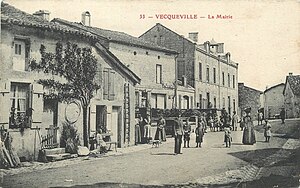
 Mairie around 1920 |
||
Vecqueville is a French commune with 529 inhabitants (as of January 1, 2017) in the Haute-Marne department in the Grand Est region ; it belongs to the arrondissement of Saint-Dizier and the community association Bassin de Joinville en Champagne .
geography
Vecqueville is located around 25 kilometers southeast of the city of Saint-Dizier in the north of the Haute-Marne department. The community lies in an arch of the Marne . In terms of traffic, the community is easily accessible with its own connection to the N67 .
history
Historically, Vecqueville belongs to the Bailliage de Chaumont within the province of Champagne . The place belonged from 1793 to 1801 to the District Joinville. Also from 1793 to 1801 to the canton of Maiziéres and from 1801 to the canton of Joinville. The parish was assigned to the Arrondissement Wassy from 1801 to 1926 and 1940 to 1943 and the Arrondissement Chaumont from 1926 to 1940. Since 1943 it has belonged to the Arrondissement of Saint-Dizier.
Population development
| year | 1962 | 1968 | 1975 | 1982 | 1990 | 1999 | 2006 | 2017 | |||||
|---|---|---|---|---|---|---|---|---|---|---|---|---|---|
| Residents | 763 | 809 | 721 | 766 | 746 | 701 | 626 | 529 | |||||
| Sources: Cassini and INSEE | |||||||||||||
Attractions
- 19th century village church of Saint-Remy (few parts from the 15th century)
- Chapel of Sainte-Anne de Sossa
- Wayside cross east of the village
