Frankfurt-Nordend
|
Nordend-West Nordend-Ost 6/7. District of Frankfurt am Main |
|
|---|---|
| surface | 4.632 km² |
| Residents | 54,079 (Dec. 31, 2019) |
| Population density | 11,675 inhabitants / km² |
| Post Code | 60316, 60318, 60320, 60322, 60389 |
| prefix | 069 |
| Website | www.frankfurt.de |
| structure | |
| District | 3 - city center III |
| Townships |
North End West |
| Transport links | |
| Federal road |
|
| Tram and subway | U1 U2 U3 U4 U5 U8 12 18 |
| bus | 30 32 34 36 64 75 n1 n2 n3 n4 n11 n82 |
| Source: Statistics currently 03/2020. Residents with main residence in Frankfurt am Main. Retrieved April 8, 2020 . | |

The Nordend ( ) is a district of Frankfurt am Main . For statistical purposes it is divided into north-end-west and north-end-east , but is usually viewed as a unit. The Friedberger Landstrasse forms the border between west and east . The Nordend is considered a district with bourgeois and upscale residents and expensive real estate.
Together with the Westend , the Bahnhofsviertel and the Ostend , the Nordend belongs to the Wilhelminian -style and highly dense Frankfurt inner-city districts . A gentrification process is currently underway in the Nordend .
The north end forms the district of Innenstadt III . With 54,079 inhabitants in an area roughly equivalent to that of the relatively small Frankfurt-Höchst , the Nordend has the highest population density in the Frankfurt urban area and, in absolute terms, has the second highest number of inhabitants after Sachsenhausen .
Demarcation
The neighborhood borders the north of the investment ring at the center of Frankfurt . In the north it extends far beyond the outer Frankfurt Ringstrasse, the Alleenring , so that today there is no clear demarcation to the adjoining districts. The Eschenheimer Turm in the southwest, the radio house of the Hessischer Rundfunk and the new Jewish cemetery in the north, the Friedberger Warte in the northeast and the Günthersburgpark in the east can be roughly identified as border points.
The significantly smaller Northrend-East borders the sandy path to the Frankfurt's Ostend . The boundary to the Bornheim district runs along Höhenstraße, Burgstraße and Comeniusstraße, through the Bornheim water park and cemetery along Dortelweiler Straße to Friedberger Landstraße.
Nordend-West lies between Friedberger Landstrasse in the east and Eschersheimer Landstrasse in the west. In addition to the Nordend-Ost, it also borders Bornheim to the east and the Westend to the west . The northern boundary to the Dornbusch district is marked by the Bertramswiese and the Kühhornshofweg. The border to Eckenheim runs right through the main cemetery .
Attractions
Parks and green spaces
The largest green space in western Nordend is the 75 hectare main cemetery between the two important traffic routes, Eckenheimer Landstrasse and Friedberger Landstrasse , which surrounds the Jewish cemetery Rat-Beil-Strasse in the southeast . The northern part of the main cemetery and the new Jewish cemetery to the northwest already belong to the Eckenheim district . At the western end of the district is the Holzhausenpark with the little Holzhausenschlösschen.
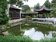
In the eastern north end of the Günthersburgpark and the Bethmannpark should be mentioned. The latter borders immediately to the north on the Friedberger Anlage , which is part of the Frankfurt Wallanlagen . The Chinese Garden of Heavenly Peace , one of the few Chinese gardens in Germany, has been located in the park as an independent walled area since 1989 . All three parks were formerly private parks of wealthy Frankfurt banking and patrician families.
building
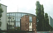
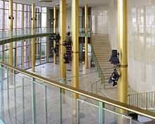
Probably the most famous building in the north end is the " Funkhaus am Dornbusch ". Shortly after the Second World War, the German Bundestag was to be located on this site , which is why construction of the future plenary hall began in the immediate vicinity of the existing building complex of a former teacher training institute . When Frankfurt was narrowly defeated in the question of the capital city of Bonn, the inside of the round building was expanded as a broadcasting center for radio broadcasting . Only the exterior view and the vestibule intended as a foyer for the Bundestag (“Goldhalle”) remained unaffected by the redesign; the “rotunda” was modeled on the architect of the Paulskirche in Frankfurt , the seat of the first German National Assembly . Until 1999, the “Rundbau” housed the radio studios with the exception of the news studios, editing rooms for pre-productions, radio play studios and offices for radio technology.
Adjacent to the "rotunda" was later built the hr broadcasting hall , a large hall for concerts and other public events, the entrance of which is now the "Goldhalle". The entire complex of the HR site, on which the radio and television control centers of the ARD were housed in a high-rise building , was then given the name of the adjacent district .
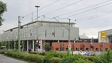
Not far away is the German Library at the intersection of Nibelungenallee / Eckenheimer Landstrasse, which was established in Frankfurt in 1946 to collect German documents for the western zones . Since reunification , it has been the second location of the German National Library alongside the German Library in Leipzig . The building can be easily recognized by the artistically placed brick sculptures.
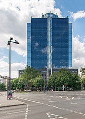
The highest skyscraper in the district is on Nibelungenplatz. It was built by Shell in 1966 and is 110 m high. The then tallest building in the city had, among other things, a nuclear shelter in the basement. After being extensively rebuilt in 1993 and fitted with a panoramic elevator, it is now known as the City Gate .
For a few years now, the Frankfurt am Main police headquarters have also been located in the Nordend . The complex is conveniently located at the intersection of Miquel- / Adickesallee / Eschersheimer Landstrasse.
In addition to the distinctive individual buildings, the north end is characterized by multi-storey residential buildings from the late 19th century. In the southern part of the two districts, close to the city center, there is an almost continuous development in the style of the Wilhelminian era , the neo-renaissance and the late classicism . Further north, the houses tend to have fewer floors and are furnished in the manner of villas.
Churches
In 1888, the Luther Church and the Methodist Church of Zion were the first to be built in the north end. In 1900 the Immanuelkirche , built by the ecclesiastical aid association , followed , in 1906 St. Bernhard was the first Catholic church in the Nordend and St. Albert in 1937/38 . The churches were destroyed by the air raids on Frankfurt am Main in World War II and rebuilt in the 1950s. Several new churches were built for this purpose: The Church of St. Michael was built in 1953, the Wartburg Church in 1960 and finally the Gethsemane Church in 1969 . In 2007 the Diocese of Limburg established the Center for Bereavement Pastoral Care of the Diocese of Limburg in the Church of St. Michael .
Infrastructure and traffic
The Nordend is one of the best connected districts in Frankfurt. In the east-west direction, both the north-end-west and the north-end-east are accessed from the Alleenring . Three important arterial roads run in north-south direction: The westernmost is the Eschersheimer Landstrasse in the direction of Oberursel (Taunus) and Bad Homburg vor der Höhe . This is followed by the Eckenheimer Landstrasse at the main cemetery and the Friedberger Landstrasse , which is part of the Bundesstrasse 3 .
But the Nordend also has the greatest density of underground trains in Frankfurt. Three line branches ( U1 / U2 / U3 / U8, U4, U5 ) run through the districts and stop there at a total of ten stations (Nordend-West: 8, Nordend-Ost: 2). In addition, a traffic from the lines 12 and 18 route of the tram . It is on Friedberger Landstrasse; the underground lines run below or on Eschersheimer Landstrasse, Eckenheimer Landstrasse and Berger Strasse. However, the district has no connection to the network of the S-Bahn or regional trains .
The construction of a route for the federal motorway 66 is currently being discussed, which would also run through the Nordend-Ost from Rat-Beil-Straße in order to establish a connection with the A 661 . The construction of an adjoining tunnel below the Alleenring, as we have been talking about for 40 years, is, at least for the time being, inconceivable.
On August 12, 2008, the first “ meeting zone ” in Germany was inaugurated in Frankfurt am Main , but as a traffic-calmed area . Following the Swiss model, three residential streets in the Nordend were given new types of floor markings and a walking pace was established.
history
Prehistory and manors
The area of the north end was already settled in ancient times. Long before the city of Frankfurt was founded, near Günthersburg Park on today's Hartmann-Ibach-Strasse was a Roman villa with an estate that belonged to the city of Nida , today's Frankfurt-Heddernheim . In the Middle Ages, some royal farms were built , which at the turn of the modern era became mansions for the Frankfurt patricians . The names of some of these farms can still be found in street names:
- Kühhornshof , later Bertramshof
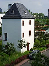
- The defense tower of the Kühhornshof, built from massive rubble stones and surrounded by a moat for a long time, survived on the HR site. It was probably built at the beginning of the 16th century on the remains of a collapsed previous building and was given its present form in 1715. In 1600 Heinrich von Bertram bought the farm. The name Bertramshof has been used since then. The streets Kühhornshofweg, Bertramstraße and Bertramwiese, which also represent the northernmost extension of Nordend-West, are reminiscent of this courtyard. The Bertramstrasse and the Bertramshof are well known beyond the region through the hr . After extensive restoration, the tower now houses a seminar room and a fireplace room.
- Holzhausenhof or Holzhausen- Oed , because of the remoteness
- In addition to the still preserved Wasserschlösschen, which the patrician family Holzhausen had built in the 18th century, and Holzhausenstraße, which touches the former courtyard to the north, the Oeder Weg, which has long led to the (Holzhausen-) Oed, reminds of this manor. The surrounding Annastraße, Justinianstraße and Hammanstraße refer to the first names of individual family members.
- Stalburger Hof or Stalburger Oede , east of the Holzhausen-Oeds
- The Oeder Weg branched off there. Today Stalburgstrasse runs north of it.
- Glauburg court
- This farm was between Friedberger and Bornheimer Heide . In 1690 the farm fell into the hands of Johann Jakob Günther, the namesake of today 's Günthersburg Park , which was created in place of the farm.
Since the end of the 14th century, these manors were protected by the Frankfurter Landwehr .
Founding period
The name Nordend was created around 1850. At that time, it represented the northernmost expansion of the urban development. The area between the former core city and the "funny village" Bornheim was designated as a residential area in the building zone plan of Frankfurt and from the early days to the turn of Built in the nineteenth to the twentieth centuries, it became the most densely populated area. Wide avenues in Wilhelmine style emerged, and even today red sandstone is often used to clad the plinths of the mostly four-story rows of houses. At the end of the 19th century, attempts were made for the first time to divide the urban area into statistical districts . The north end consisted of the districts 12, 13, 20, 21, 22, 23 and 24. This numbering has remained almost unchanged to this day. Under Lord Mayor Franz Adickes , the Nordend and the other Wilhelminian districts expanded strongly. In order to set a limit for the development, a second ring road was created to enclose the densely populated residential areas.
Social milieu
In a real satire , Günter Franzen describes the social milieu of Nordend.
literature
- Jörg Harraschain / Holger Ehling: Northrend. The most beautiful forays through Frankfurt . Societätsverlag, Frankfurt / Main 2011. ISBN 978-3-942921-07-7
- Schwarzburg office: Nordend . District magazine, Frankfurt 2010–2013
Web links
Individual evidence
- ^ Official Journal of the Diocese of Limburg, No. 2, February 1, 2007, No. 448, document on the establishment of the profile church “St. Michael - Center for Mourning Pastoral “, Frankfurt am Main
- ↑ Excitement about the anthem - Die Wacht am Main (FAZ, November 3, 2012)
Coordinates: 50 ° 7 ' N , 8 ° 42' E


