Guerbigny
| Guerbigny | ||
|---|---|---|
|
|
||
| region | Hauts-de-France | |
| Department | Somme | |
| Arrondissement | Montdidier | |
| Canton | Roye | |
| Community association | Grand Roye | |
| Coordinates | 49 ° 42 ′ N , 2 ° 40 ′ E | |
| height | 52-101 m | |
| surface | 8.27 km 2 | |
| Residents | 293 (January 1, 2017) | |
| Population density | 35 inhabitants / km 2 | |
| Post Code | 80500 | |
| INSEE code | 80395 | |
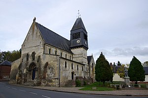
 The Saint-Pierre church with the war memorial |
||
Guerbigny is a northern French municipality with 293 inhabitants (at January 1, 2017) in the department of Somme in the region of Hauts-de-France . The municipality is located in the arrondissement of Montdidier and belongs to the canton of Roye .
geography
The municipality is located in the Santerre countryside around 10.5 km west of Roye on both banks of the Avre . The departmental road D329 from Rosières-en-Santerre to Montdidier runs through the municipality, which has grown together with the neighboring municipality of Warsy , and crosses the departmental road D160 in its northern part.
history
The community received the Croix de guerre 1914-1918 as an award .
Residents
| 1962 | 1968 | 1975 | 1982 | 1990 | 1999 | 2006 | 2010 |
|---|---|---|---|---|---|---|---|
| 289 | 265 | 256 | 232 | 233 | 233 | 261 | 263 |
administration
Mayor ( maire ) has been Alain Soufflet since 2008.
Attractions
- The Saint-Pierre church, classified as a Monument historique since 1919 ( Base Mérimée PA00116170).
Web links
Commons : Guerbigny - collection of images, videos and audio files
