
Atlantic hurricane season 2018
 All the storms of the season | |
| Formation of the first storm |
May 25, 2018 |
|---|---|
| Dissolution of the last storm |
October 31, 2018 |
| Strongest storm | Michael - 919 hPa ( mbar ), 135 kn (250 km / h ) (1 minute) |
| Tropical lows | 16 |
| Storms | 15th |
| Hurricanes | 8th |
| Severe hurricanes ( Cat. 3+ ) | 2 |
| Total number of victims | 154 |
| Total damage | ≥ $ 33.27 billion (2018) |
|
Atlantic hurricane season 2016 , 2017 , 2018 , 2019 , 2020 | |
The 2018 Atlantic hurricane season officially began on June 1, 2018 and officially ended on November 30, 2018. During this period, most hurricanes usually form in the northern Atlantic Ocean , as only suitable conditions exist at this time, such as a warm ocean, humid Air and little wind shear to allow tropical cyclones to form.
Since the beginning of the 2017 Atlantic hurricane season, the National Hurricane Center (NHC) has been able to issue warnings about disturbances that do not yet have tropical characteristics but that have high potential for tropical cyclogenesis and expect storm or hurricane conditions for inhabited areas within 48 hours become. Such systems are called “potential tropical cyclones”.
With the formation at 19.3 ° north latitude, Alberto was the most southern subtropical storm after Olga in 2007 .
Tropical cyclones in the Pacific Ocean see the article: Pacific Hurricane Season 2018 .
Season forecasts
| source | date |
tropical storms |
Hurricanes |
severe hurricanes |
|
| Average (1981-2010) | 12.1 | 6.4 | 2.7 | ||
| highest activity | 28 | 15th | 7th | ||
| least activity | 4th | 2 † | 0 † | ||
| –––––––––––––––––––––––––––––––––––––––––––––––––– ––––– | |||||
| TSR | 7th December 2017 | 15th | 7th | 3 | |
| CSU | 5th April 2018 | 14th | 7th | 3 | |
| TSR | 5th April 2018 | 12 | 6th | 2 | |
| NCSU | April 16, 2018 | 14-18 | 7-11 | 3-5 | |
| TWC | April 19, 2018 | 13 | 7th | 2 | |
| NOAA | May 24, 2018 | 10-16 | 5-9 | 1-4 | |
| UKMO | May 25, 2018 | 11 * | 6 * | N / A | |
| TSR | May 30, 2018 | 9 | 4th | 1 | |
| CSU | May 31, 2018 | 14th | 6th | 2 | |
| CSU | 2nd July 2018 | 11 | 4th | 1 | |
| TSR | 5th July 2018 | 9 | 4th | 1 | |
| CSU | 2nd August 2018 | 12 | 5 | 1 | |
| TSR | August 6, 2018 | 11 | 5 | 1 | |
| NOAA | August 9, 2018 | 9-13 | 4-7 | 0-2 | |
| –––––––––––––––––––––––––––––––––––––––––––––––––– ––––– | |||||
|
actual activity |
15th | 8th | 2 | ||
| * June – November † last year multiple occurrences |
|||||
Before and during the season, several national meteorological services and scientific institutes publish forecasts of how many tropical storms, hurricanes and severe hurricanes (SSHS Category 3 and above) will form in the season and / or how many tropical cyclones will hit a particular country become. These institutes include the Tropical Storm Risk (TSR) Consortium of the University College London, the National Oceanic and Atmospheric Administration (NOAA), and the Colorado State University (CSU). The forecasts take into account weekly and monthly changes in significant factors that influence the assessment of the course of the hurricane season. Some of these predictions also take into account the history of previous hurricane seasons with similar circumstances and a hitchhiker of La Niña that formed in November 2017. Between 1981 and 2010, there were twelve tropical storms, six hurricanes, and two major hurricanes in one hurricane season, and the Accumulated Cyclone Energy (ACE) index was between 66 and 103.
Predictions before the start of the season
The first forecast for the season was released by TSR on December 7th. TSR assumed a slightly above-average active season with 15 tropical storms, seven of which were hurricanes and three of them were severe hurricanes. The CSU announced its first season forecast on April 5, 2018. Accordingly, a slightly above-average active season was also expected, with 14 tropical storms, seven hurricanes and three severe hurricanes. On the same day TSR updated its forecast. TSR now expected a slightly below-average active season with twelve tropical storms, six hurricanes and two severe hurricanes, with the now assumed lower activity being attributed to anomalous cooling in the extremely northern and tropical North Atlantic. On April 16, North Carolina State University announced its forecast of an above-average active season. The NCSU expected 14-18 tropical storms, of which 7-11 hurricanes, of which 3-5 were severe hurricanes. The Weather Company assumed a nearly average season in their May 17 forecast; accordingly, 13 tropical storms would develop, including seven hurricanes, two of which were Category 3 or higher on the Saffir-Simpson Hurricane Wind Scale . NOAA released its first seasonal forecast on May 24th. It assumes that the season will be almost above average. On May 25, the British Met Office published eleven tropical storms, six of which would reach hurricane status and an Accumulated Cyclone Energy (ACE) of around 105. In contrast, TSR lowered the numbers significantly to nine in their May 30 update Storms, four hurricanes and one major hurricane; this was justified with the setup of the water surface temperatures, which is usually during the cool phase of the Atlantic Multi-Decade Oscillation . Finally, on May 31, the CSU updated its forecast for the last time before the start of the season to take into account the early development of subtropical storm Alberto with lower numbers due to the cold anomalies in the tropical and extreme northern areas of the Atlantic.
Predictions during the season
On July 2, the CSU updated their forecast once more, and lowered the numbers to 11 named storms, four of which would intensify into hurricanes, one of which would reach the strength of a severe hurricane, and justified this with the continued cooling in the Atlantic Ocean as well as the increasing likelihood of an El Niño forming later in the year. TSR released its fourth forecast on July 5th, sticking to the previous forecast unchanged. In its August 2 update, the CSU increased its forecast to twelve named storms with five hurricanes, one of which was a severe one, and pointed to the weak El Niño that formed later in the year. Four days later, TSR released its last season forecast with slightly increased numbers: eleven named storms, five of which were hurricanes, one of which would be a major hurricane. TSR justified this with the surprising formation of two hurricanes at the beginning of July. On August 9, NOAA announced its revised forecast and now predicted a below-average active season with 9-13 named storms, 4-7 hurricanes and 0-2 major hurricanes for the 2018 season. However, NOAA's pre-season forecast was better (and the only forecast exactly in line with actual activity) than its during-season forecast.
Season overview
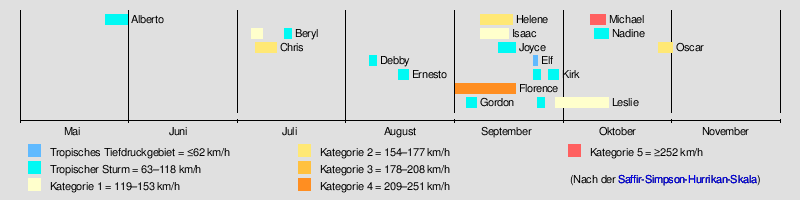
For the fourth year in a row, the Atlantic hurricane season started early when subtropical Storm Alberto formed on May 25. Alberto reached wind speeds of 100 km / h and came across land in the far west of the Florida Panhandle . The storm moved northward, weakened and turned into a tropical system as a low pressure area over Tennessee . Finally, on May 31, Alberto dissolved over Lake Michigan . No tropical depression developed in June. The period of inactivity ended when, on July 5, Hurricane Beryl formed in the Main Developmental Region (MDR ). It first dissolved shortly before reaching the Caribbean Sea and reformed on July 14th in the Atlantic Ocean. Beryl finally broke up on July 16. Chris formed on July 6, intensified into a Category 2 hurricane on July 11, and dispersed over the Canadian Maritime Provinces the following day . Tropical storms Debby and Ernesto formed in August, neither of which came near land. Ernesto was meanwhile a subtropical storm and at this point it was already the fourth subtropical storm of the season.

Hurricane Florence next formed on August 31st and became the first major hurricane of the season on September 5th. After making landfall in North Carolina on September 14, Florence became the wettest tropical cyclone in recorded weather there and in neighboring South Carolina . Activity increased significantly in September. Tropical Storm Gordon formed on September 3, followed by Hurricanes Helene and Isaac on September 7, with Isaac affecting the Lesser Antilles and the Azores and the United Kingdom. Tropical Storm Joyce formed on September 12 and remained in the open Atlantic Ocean and dissolved on September 19 with no impact on land. After a brief period of inactivity, Tropical Depression Elf and Tropical Storm Kirk formed on September 22, followed by subtropical Storm Leslie a day later. Kirk became a tropical storm at 8.3 ° N, which is the lowest latitude of a tropical storm or hurricane in the North Atlantic since Hurricane Three during hurricane season 1902 (the lowest latitude of the formation of a tropical depression in the North Atlantic was 7.2 ° N in the 1990 hurricane season ). Leslie's emergence marked the first time since reliable records began that six storms (Alberto, Beryl, Debby, Ernesto, Joyce and Leslie) were temporarily classified as subtropical storms in a hurricane season.
The activity started again in October. Michael formed on October 7th and intensified over the Gulf of Mexico into a major hurricane before hitting the Florida Panhandle on October 10th . One day later, the short-lived Storm Nadine developed in the eastern tropical Atlantic, and on October 13, after 15 days as a tropical system, Hurricane Leslie turned into a powerful non-tropical storm about 200 km west of the Iberian Peninsula before it hit the Portuguese coast.
With the upgrade to a tropical storm at 30 degrees west longitude, Nadine became the most easterly tropical storm that formed in the Atlantic Ocean so late in the calendar year. A two-week period of inactivity ushered in the end of the hurricane season. Finally, on October 27, the seventh subtropical storm of the season formed with Oskar. This means that the hurricane season 2018 set the start of satellite observations is the season with the most subtropical storms. Oscar intensified the next day into the eighth hurricane of the year. With the dissolution of the Oscars on October 31st, the hurricane season ended because no tropical systems formed in the Atlantic Ocean in November. 2018 was the first year since 2014 that this was the case.
Storms
Subtropical storm Alberto
| Subtropical Storm ( SSHWS ) | |||
|---|---|---|---|
|
|||
| Duration | May 25th - May 31st | ||
| intensity | 55 kn (100 km / h ) (1 minute) , 990 hPa | ||


An extensive depression formed over the southwestern Caribbean Sea on May 21 after a high altitude low and a trough close to the ground interacted. The low drifted slowly westward and then northward through the Caribbean Sea, steadily organizing itself, despite strong wind shear . On May 25 at 3:00 p.m. UTC, development was so advanced that the system, located about 90 km south of Cozumel in the Mexican state of Quintana Roo , was classified as a subtropical storm and given the name Alberto , although the system was eastern at the time the Yucatán Peninsula had several circulation centers that interacted with an elevated trough.
The system shifted northward, and on May 26, circulation re-established north of Cuba under the primary convection in the Gulf of Mexico . Early on May 28th, continuous wind speeds of 100 km / h and a rolled center were observed during a flight of the Hurricane Hunters into the storm center. Early on May 28th, Alberto reached its greatest intensity with sustained wind speeds of 100 km / h. Due to the influx of dry air, the storm could not develop into a fully tropical storm and weakened before landfall at 21:00 UTC with winds up to 75 km / h at Laguna Beach . Alberto weakened rapidly overland, but continued to generate torrential rain in the southeastern United States .
In western and central Cuba, due to the passage of Alberto, there was heavy rainfall for days, which led to sometimes severe flooding. There was severe damage to buildings and agriculture. Numerous places were cut off from the outside world. 16,000 people were evacuated. Four people died. Two people are missing. In North Carolina , two journalists were killed by a tree, and in Maryland , a National Guard died trying to rescue a woman from the floods of a flooded river.
Hurricane Beryl
| Category 1 hurricane | |||
|---|---|---|---|
|
|||
| Duration | July 5th - July 16th | ||
| intensity | 70 kn (130 km / h ) (1 minute) , 994 hPa | ||


On late July 3, the NHC began tracking a powerful tropical wave over the eastern Atlantic. The wave quickly merged as it moved west, and on July 5 at 15:00 UTC it organized into a tropical depression over the central tropical Atlantic. Favorable conditions allowed the tiny system to amplify into tropical storm Beryl at 18:30 UTC and transform into a Category 1 hurricane at 06:00 UTC on July 6 when a hole became visible in the eye. After classification as a hurricane, it became the second earliest in the main development region (<20 ° N, 60-20 ° W), only surpassed by Hurricane Two in 1933. This intensity was short-lived as the accelerated deep currents increased the wind shear and weakened the system back to tropical storm strength by July 7 at 15:00 UTC. An Air Force reconnaissance plane examined the system early in the morning and found that Beryl had degenerated into an open trough; the NHC declassified Beryl accordingly on July 8th at 21:00 UTC as a tropical cyclone. The remains were monitored for several days, although little organization took place during much of that time. On July 14th at 17:00 UTC, Beryl regenerated into a subtropical storm near Bermuda. The storm soon began to lose convection as dry air entered the system. On July 16 at 03:00 UTC, Beryl degenerated back to a residual low after having had no organized convection for more than twelve hours.
Hurricane Chris
| Category 2 hurricane | |||
|---|---|---|---|
|
|||
| Duration | July 6th - July 12th | ||
| intensity | 90 kn (165 km / h ) (1 minute) , 969 hPa | ||


Late on July 2, the NHC began assessing the potential for the formation of a low pressure system in a low-level circulation near Bermuda . A nontropical depression formed a few hundred kilometers south of Bermuda on July 3rd. Showers and thunderstorms increased as the low moved northwest across the Gulf Stream . On July 6th at 9:00 p.m. UTC, the low off the coast of North Carolina organized into Tropical Depression Three. The system strengthened slowly because the circulation was rolled out in an oval shape. Nevertheless, the low pressure area was upgraded to Tropical Storm Chris on July 8th at 09:00 UTC. Although a hurricane intensification was forecast for the following day, the ingress of dry air and upwelling caused by the storm meant that the storm intensified only slightly. However, the next day the storm managed to get rid of the dry air from its circulation as the storm moved northeast over warmer water. With a well-defined eye and an impressive appearance on the satellite images, Chris finally turned into a hurricane on July 10th at 21:00 UTC. After intensifying rapidly, Chris was promoted to Category 2 six hours later because a ring of convection in its core had turned into a complete eye wall. During the course of the day, however, the eye frayed and appeared ill-defined, so that Chris weakened to Category 1 at 21:00 UTC. Although the hurricane continued to cross the Gulf Stream, it lost hurricane status the next morning. By this point, Chris had already started transitioning to an extra-tropical system, and the wind field was expanding; hours later after the transition, Chris incorporated himself into a frontal gravure system.
A man drowned in rough seas attributed to Hurricane Chris on July 7 at Kill Devil Hills on the North Carolina coast . As an extra-tropical low pressure system, Chris brought heavy rain and gusty winds locally to Newfoundland and Labrador . The amount of precipitation in Gander reached 76 mm, while the strongest gust of 96 km / h is measured in Ferryland . On Sable Island there was an accumulation of 111.6 mm of precipitation.
Tropical storm Debby
| Tropical storm | |||
|---|---|---|---|
|
|||
| Duration | August 7th - August 9th | ||
| intensity | 45 kn (85 km / h ) (1 minute) , 1000 hPa | ||


On August 4th, the NHC began observing a nontropical low over the North Atlantic for tropical or subtropical development. At first, the convection remained fairly limited, and the system consisted mostly of a non-convection vortex that interacted with an altitude depression. The system then got into a more favorable environment and gradually began to build up subtropical properties. At 3:00 p.m. UTC on August 7, the depression had built up sufficient convection to be classified as Subtropical Storm Debby. The storm developed enough tropical characteristics on its way north and became a fully tropical storm on August 8 at 09:00 UTC when the sustained one-minute winds increased to 75 km / h. Despite marginal ocean temperatures, Debby continued to gain strength and peaked with sustained wind speeds of 85 km / h. Subsequently, Debby began to weaken and lose the tropical characteristics. On August 9, at 9:00 p.m. UTC, Debby degenerated into a post-tropical cyclone and raced northeast from a shortwave trough.
Tropical storm Ernesto
| Tropical storm | |||
|---|---|---|---|
|
|||
| Duration | August 15 - August 18 | ||
| intensity | 40 kn (75 km / h ) (1 minute) , 999 hPa | ||


A complex, nontropical depression formed over the northern Atlantic on August 12th. While the low drifted southeast and slowly weakened, a new low pressure area arose east of the system on August 14th. The new depression quickly acquired subtropical characteristics, and by August 15 at 09:00 UTC the system had organized itself sufficiently to be classified as a subtropical depression. Six hours later, the low pressure area was upgraded to subtropical storm Ernesto. On August 16, the system initially attempted to become a completely tropical storm - convection developed around the center - but it soon died away. Even so, a few hours later convection broke out again near the center, suggesting that Ernesto had successfully assumed tropical properties. On August 17, Ernesto began accelerating his train speed northeast because the system had been caught by the jet stream. The next day, the storm lost its tropical properties. The remnants of Ernesto met Ireland and the United Kingdom on August 19 .
Hurricane Florence
| Category 4 hurricane | |||
|---|---|---|---|
|
|||
| Duration | August 31st - September 17th | ||
| intensity | 120 kn (220 km / h ) (1 minute) , 939 hPa | ||


On August 28, the NHC first mentioned the possibility of a tropical trough forming from a tropical wave once it reached the waters off West Africa. Two days later the wave broke off the coast of Senegal with little organized thunderstorms and a well-defined low pressure area formed. Because the system posed a threat to the Cape Verde Islands , the NHC made use of the option introduced in 2017 and began issuing warnings of a potential tropical cyclone on August 30 at 3:00 p.m. UTC . The system gained organization and was declared the sixth tropical depression of the season on August 31 at 21:00 UTC.
Early on September 1st, the low pressure area intensified into Tropical Storm Florence. The storm continued to develop as Florence moved west-northwest across the central Atlantic and had intensified on September 4 at 15:00 UTC for the third hurricane of the season. On September 5th, Florence unexpectedly intensified into Category 3 and thus into a severe hurricane. The rapid intensification continued, and by 21:00 UTC Florence had stepped up to Category 4 at 22.4 ° North and 46.2 ° West, further northeast than any previous Category 4 hurricane in the Atlantic since the start of the weather satellite era . The rapid intensification also meant that the now stronger storm was diverted northwards into a zone with stronger vertical wind shear . This caused Florence to weaken into a tropical storm over the next 30 hours. The cloudscape of the storm looked rather scattered. After the storm hit an area with less wind shear and warmer waters, Florence turned into a hurricane again on September 9. The next day, after a second phase of rapid intensification, Florence intensified again into a severe hurricane. At 4:00 p.m. UTC on September 11, Florence was upgraded to a Category 4 hurricane.
Before the hurricane affected the coast, however, it underwent an eyewall renewal and encountered moderate wind shear, so that the hurricane weakened to Category 2. Overland, Florence quickly weakened to a tropical depression, and the NHC transferred responsibility to the Weather Prediction Center (WPC) on September 16 at 10:00 UTC . at this point Florence began to pull faster in a westerly direction. on September 17, the low pressure area slowly turned to the northeast and weakened further. late in the same day the system weakened to a residual low over West Virginia . Florence was still a threat inland as the system dumped enormous amounts of rainfall over the east coast of the United States. The system finally disintegrated over the open Atlantic on September 19th.
Tropical storm Gordon
| Tropical storm | |||
|---|---|---|---|
|
|||
| Duration | September 3 - September 6 | ||
| intensity | 40 kn (75 km / h ) (1 minute) , 997 hPa | ||


On August 30, the NHC began monitoring a tropical disturbance over the north-central Caribbean . The system moved northwest towards the Bahamas , steadily intensifying, and on September 2 at 6:00 p.m. UTC the system was named Potential Tropical Cyclone Seven because of the projected effects on land at the strength of a tropical storm went out within two days. The next day at 12:05 p.m. UTC, the system organized itself into a tropical storm and was named Gordon as it was crossing the Florida Keys . Although the storm intensified slightly as it swept across southern Florida, the core became irregular and the convection disorganized. Arriving over the Gulf of Mexico late September 3, Gordon began gaining strength and organization, and a deep convection band developed near the small core. Late on September 4th, Gordon reached its peak intensity with sustained one-minute winds of 110 km / h, shortly before it hit the mainland just west of the state line between Alabama and Mississippi . After the landfall, Gordon weakened into a tropical depression. For the next two days, Gordon moved over the southern states before finally losing tropical features on September 8th. These remnants continued on their way northeast, dumping large amounts of rainfall before being absorbed by another frontal system over New England on September 12 .
Hurricane Helene
| Category 2 hurricane | |||
|---|---|---|---|
|
|||
| Duration | September 7th - September 16th | ||
| intensity | 95 kn (175 km / h ) (1 minute) , 966 hPa | ||


After intensification off the coast of Africa with rains there and a temporary upgrade to Category 2 hurricane before crossing the Ross Breiten , the former weakened hurricane Helene approached the island area of the Azores and Europe on September 12th .
Moving northwards, Helene first passed the much smaller sub-tropical storm Joyce , which was moving southwards , and turned westwards into the westerly wind zone . For the likely path of the storm, crossing the islands of Flores and Corvo was expected by NOAA on Saturday or Sunday the 16th; at first it was uncertain how severely the main islands of the archipelago would be affected. On the night of September 16, the center of the storm passed the western Azores at about 100 km / h near Flores and continued towards Ireland as a storm low. Higher amounts of energy in the atmosphere above the sea west of Africa also mean more dynamism and uncertainty about whether storms like Helene will also have an impact on Europe.
Hurricane Isaac
| Category 1 hurricane | |||
|---|---|---|---|
|
|||
| Duration | September 7th - September 15th | ||
| intensity | 65 kn (120 km / h ) (1 minute) , 992 hPa | ||


Isaac emerged as Tropical Low Pressure Area Number Nine on September 7, 2018 around 5:00 p.m. AST (Atlantic Standard Time ), i.e. 11:00 p.m. CEST (Central European Summer Time). About a day later it became Tropical Storm and got its name. From then on he moved westwards, almost exactly towards Guadeloupe , Dominica and Martinique, without significant north-south deviations . At around 11:00 p.m. AST on September 9, it had become a Category 1 hurricane, the fifth in the 2018 season. However, it weakened before reaching land and became AST on September 10 around 11:00 p.m. downgraded to Tropical Storm. As such, he crossed the Lesser Antilles , with the center passing AST between Dominica and Martinique on September 13 at around 2:30 p.m. It was downgraded to Tropical Depression on the night of September 13-14 at around 2:00 a.m. AST. During the course of September 14th it briefly turned back into a tropical storm. At around 5:00 a.m. AST on September 15, Isaac was found to have broken up.
Tropical storm Joyce
| Tropical storm | |||
|---|---|---|---|
|
|||
| Duration | September 12th - September 19th | ||
| intensity | 40 kn (75 km / h ) (1 minute) , 1002 hPa | ||


The NHC began observing a nontropical low pressure area that formed in a low pressure trough on September 11th. Although initially predicted to be slow, the system quickly acquired subtropical properties as it moved southwest and strengthened. As a result, it was declared Subtropical Storm Joyce on September 12th at 21:00 UTC. At 3:00 a.m. UTC on September 14th, Joyce had assumed tropical characteristics. During the course of the day Joyce turned in an easterly direction. Joyce reached its greatest intensity late on September 14th and was more organized on the satellite images. After that, the storm began to ease as the wind shear increased. On September 16 at 3:00 p.m. UTC, Joyce weakened to a tropical depression. The system moved further east before turning south. Dry air eventually caused the system to lose all tropical properties on September 19.
Tropical Deep Elf
| Tropical depression | |||
|---|---|---|---|
|
|||
| Duration | September 22nd - September 23rd | ||
| intensity | 20 kn (35 km / h ) (1 minute) , 1009 hPa | ||


On September 18, a large area of disturbed weather associated with a tropical wave developed far east-southeast of the Lesser Antilles. The system initially lacked a near-surface circulation, and although one formed on September 21, strong high-altitude winds and dry air suggested that development would remain limited. The deep convection was offset to the east from the center, but became permanent in the course of the day and led to the formation of a tropical depression on September 22nd at 03:00 UTC. One day later at 3:00 p.m. UTC the low pressure area weakened and degenerated into an elongated trough.
Tropical Storm Kirk
| Tropical storm | |||
|---|---|---|---|
|
|||
| Duration | September 22nd - September 29th | ||
| intensity | 50 kn (95 km / h ) (1 minute) , 998 hPa | ||


Early on September 21, a tropical wave broke off the west coast of Africa near Sierra Leone . In contrast to the predicted slow development, the wave quickly organized itself due to favorable conditions and moved in a roughly westerly course over the extreme eastern Atlantic. By 15:00 UTC on September 22nd, the system had organized itself to be classified as Tropical Storm Kirk. Kirk's strength changed little as Kirk accelerated forward across the tropical Atlantic and, possibly because of the high speed of the train, it had weakened to a tropical depression on September 24 at around 3:00 a.m. UTC before leaving that day disintegrated into an open trough at around 15:00 UTC.
The open trough moved further west and reoginized rapidly, so that Kirk established a well-defined circulation and on September 26th at 09:00 UTC again developed into a tropical storm and storm warnings were issued again. Kirk began intensifying and reached its peak intensity at 18:00 UTC that same day with sustained wind speeds of 95 km / h. Strong wind shear ensured that the storm weakened somewhat as it approached the Lesser Antilles. The weakening continued as Kirk moved further west through the Caribbean Sea, and circulation opened up west of the main convection area. Early on September 29th, Kirk degenerated into an open tropical wave in the eastern Caribbean Sea.
Hurricane Leslie
| Category 1 hurricane | |||
|---|---|---|---|
|
|||
| Duration | September 23-13 October (post-tropical) - | ||
| intensity | 80 kn (150 km / h ) (1 minute) , 969 hPa | ||


In the middle of an active month of September, on September 19, the NHC began monitoring an area southwest of the Azores for tropical or subtropical development. On September 22nd, a nontropical depression formed there, which quickly developed into a subtropical storm by 15:00 UTC the following day, which the NHC named Leslie . After two days of only minor changes in strength, Leslie began to weaken, initially early on September 25th into a subtropical low pressure area before this became post-tropical during the day and began to merge into an approaching frontal system. As a result, Leslie merged with the frontal system and began a cyclonic loop to the west, intensifying and becoming a strong extra-tropical cyclone with gale force winds early on September 27th.
After reaching the extra-tropical climax, the post-tropical cyclone Leslie weakened steadily and lost its frontal structure. However, at the same time the storm began to reassume subtropical characteristics, and on September 28 at 9:00 p.m. UTC, Leslie was again declared a subtropical storm by the NHC. A day later, Leslie became completely a tropical system. Over the next few days, Leslie slowly drifted south-southwest, gradually intensifying. On October 3 at 9:00 a.m. UTC, Leslie intensified into a Category 1 hurricane, making it the sixth hurricane of the season. Late the next day, Leslie weakened again to a tropical storm; Satellite data indicated that Leslie was attempting a cyclical eyewall renewal , but with one very large eye. For the next few days, Leslie continued the slow drift northeast with no major changes in intensity. On October 7, Leslie turned on an east-southeast train. After a period of weakening, Leslie began to get stronger again late on October 8th over warmer water. On October 10th it had reached hurricane strength again.
On October 11, the direction of migration changed to east-northeast. Leslie lost its tropical properties on October 13 at around 6:00 p.m. UTC. According to data from the European ECMWF weather model and from NOAA, it should be on the night of October 13-14, 2018, with the center north of Lisbon a little south of Porto and gusts top speeds of 150 to 180 km / h along the Atlantic coast of Portugal and Meet Spain. The highest storm warning level was declared in Portugal.
Shortly before the landfall near Figueira da Foz , a coastal town near Coimbra at the mouth of the Mondego river , the storm eddy weakened, but still caused damage: in Portugal, up to 324,000 people were without an energy supply during the course of the storm. A. the women's European roller hockey championship in Mealhada in the Aveiro district had to be ended due to the roof of the sports hall being torn away. The strong ground-level gusts of up to 176 km / h, the highest value since the beginning of Portuguese records, are attributed to the sting jet , a strong downward current of cold air.
Hurricane Michael
| Category 5 hurricane | |||
|---|---|---|---|
|
|||
| Duration | October 6th - October 12th | ||
| intensity | 140 kn (260 km / h ) (1 minute) , 919 hPa | ||


Early on October 2, the NHC began monitoring an extensive area of low pressure that had formed in the southwestern Caribbean Sea. Although strong high-altitude winds initially hindered development, the disturbance organized itself increasingly better as it drifted first northwards and then westwards towards the Yucatán peninsula . On October 6th, the system was sufficiently organized to be declared a potential tropical cyclone due to its proximity to land and the NHC began issuing warnings about the system. Early the next morning, the system organized itself into a tropical depression before intensifying a few hours later into tropical storm Michael. Due to rapid intensification, Michael became a hurricane around noon on October 8th, and on October 9th around 9:00 pm UTC, Michael became the second major hurricane of the season. Data submitted by the Hurricane Hunters indicated that Michael continued to intensify rapidly; During October 10th, Michael intensified into a Category 4 hurricane. Part of the population was asked to evacuate; a storm surge of more than 3.5 meters was expected. Because the hurricane had intensified rapidly, the warning time for an evacuation was short.
With sustained wind speeds of 250 km / h and a minimum central air pressure of 919 mbar, Michael became the strongest hurricane of the season and, when it landed, was the third strongest hurricane in the history of the United States, hitting the comparatively poor, sparsely populated northwestern US State of Florida with the local trailer parks : The center of the hurricane moved on October 10, 2018 at around 6:00 p.m. UTC east of Panama City on the Florida Panhandle .
The combined effects of Michael's predecessor depression and a fault over the eastern Pacific Ocean caused significant floods and landslides in Central America . At least fifteen people were killed, eight in Honduras , four in Nicaragua and three in El Salvador . At least 2,000 homes in Nicaragua were damaged and 1,115 people were left homeless. A total of 253 and 180 houses respectively were damaged in El Salvador and Honduras. In total, more than 22,700 people in the three countries were directly affected by the effects.
In the United States, at least 11 deaths were initially reported as a result of "Michael", more than 520,000 homes and businesses suffered power outages and over 1,200 roads were closed. By noon on October 13 ( CEST ), the death toll had risen to 17, including five in Virginia , three in North Carolina and one in Georgia . However, there was still no connection with some of the worst affected areas. In the evening, another dead person was reported in Charlotte County, Virginia.
Tropical storm Nadine
| Tropical storm | |||
|---|---|---|---|
|
|||
| Duration | October 9 - October 13, 2018 | ||
| intensity | 55 kn (100 km / h ) (1 minute) , 997 hPa | ||


On October 7th, the NHC began monitoring a low pressure area a few hundred kilometers south of the Cape Verde Islands, which had a tropical wave late for the hurricane season, for a possible tropical development. The disturbance organized as it moved in a generally west-northwest direction across the eastern Atlantic Ocean. Because the system had established a well-defined eye, it was declared a tropical depression on October 9 at 10:00 UTC. At around 3:00 p.m. UTC, the low pressure area became a tropical storm and was given the name Nadine . The storm moved in a north-westerly direction and intensified until it reached its greatest intensity on October 10, with sustained winds of 100 km / h.
However, the small cyclone encountered an increasingly unfavorable environment, so that it weakened and strong westerly wind shear freed the circulation center near the ground. On October 13 at around 3:00 a.m. UTC, Nadine had disintegrated into an open tropical wave that continued to travel west across the tropical Atlantic Ocean. The storm did not hit land and did no known damage.
Hurricane Oscar
| Category 2 hurricane | |||
|---|---|---|---|
|
|||
| Duration | October 27th - October 31st | ||
| intensity | 90 kn (165 km / h ) (1 minute) , 970 hPa | ||


On October 23, the NHC began forecasting an area with potential for tropical or subtropical development in the central Atlantic. Later that day, a large area of disturbed weather formed associated with a near-ground trough. As the system drifted northward, it gradually intensified, showers and thunderstorms increased, although on October 26th the system still lacked a well-defined low-level circulation. At 3:00 a.m. UTC on October 27th, the circulation of the extended low had sufficiently developed that the low pressure area was declared a Sutropic Storm Oscar. Oscar strengthened further as the system swiveled southward more rapidly around the north side of a mid- and high-altitude low and turned into a fully tropical storm at 05:00 UTC on October 28. A tiny eye was briefly visible on satellite images on the evening of October 28, and at 9:00 p.m. UTC Oscar intensified into a Category 1 hurricane. The intensification continued and Oscar reached its peak intensity as a moderate category 2 hurricane with sustained winds of 165 km / h early on October 30th. Shortly afterwards, the cyclone accelerated north-east over increasingly colder water surfaces, while a cold front was approaching from the north-west . On October 31, Oscar began the transition to an extra-tropical system; this process was completed around 9:00 p.m. UTC.
Storm names
The list of names below was used for the tropical and subtropical storms that formed in the North Atlantic in 2018 . The World Meteorological Organization announced that the names Florence and Michael will be replaced with Francine and Milton in the future. The remaining names will be reused in 2024 . This list is the same as the one used during the 2012 season .
|
|
|
|
|
See also
- Pacific hurricane season 2018
- Pacific typhoon season 2018
- Cyclone season in the North Indian 2018
- Cyclone seasons in the Southwest Indicator : 2017–18 , 2018–19
- Australian cyclone seasons : 2017–18 , 2018–19
- South Pacific Cyclone Seasons : 2017-18 , 2018-19
Web links
- National Hurricane Center
- Tropical Weather Outlook of the National Hurricane Center for the Atlantic
- Graphical Tropical Weather Outlook of the National Hurricane Center for the Atlantic
- earth.nullschool.net : Global wind currents in real time
Individual evidence
- ↑ Update on National Hurricane Center Products and Services for 2017 ( English ) National Hurricane Center. May 23, 2017. Retrieved March 12, 2017.
- ↑ Philip Klotzbach: Alberto is a subtropical storm ( English ) May 25, 2018. Retrieved May 28, 2018.
- ↑ a b Background Information: The North Atlantic Hurricane Season ( English ) In: Climate Prediction Center . National Oceanic and Atmospheric Administration. July 9, 2012. Retrieved December 13, 2013.
- ↑ a b Mark Saunders: Extended Range Forecast for Atlantic Hurricane Activity in 2018 ( English , PDF) Tropical Storm Risk. December 7, 2017. Retrieved May 23, 20118.
- ↑ a b CSU External Relations Staff: Slightly above-average 2018 Atlantic hurricane season predicted by CSU team ( English ) April 5, 2018. Accessed May 23, 2018.
- ↑ a b Mark Saunders: Extended Range Forecast for Atlantic Hurricane Activity in 2018 ( English , PDF) Tropical Storm Risk. April 5, 2018. Retrieved May 23, 2018.
- ↑ a b Matthew Burns: NCSU researchers predict active hurricane season . WRAL TV. April 16, 2018.
- ↑ a b The Weather Channel: Hurricane Outlook Calls for Another Active Hurricane Season ( English ) April 19, 2018. Retrieved May 23, 2018.
- ↑ a b KCBD: NOAA predicts near or above-normal 2018 Atlantic hurricane season ( English ) May 24, 2018. Retrieved May 28, 2018.
- ↑ a b North Atlantic tropical storm seasonal forecast 2018 ( English ) Met Office . May 25, 2018. Retrieved September 12, 2018.
- ↑ a b Mark Saunders: Pre-Season Forecast for Atlantic Hurricane Activity in 2018 ( English ) Tropical Storm Risk. May 30, 2018. Retrieved September 12, 2018.
- ^ A b Philip J. Klotzbach: Extended Range Forecast of Atlantic Seasonal Hurricane Activity and Landfall Strike Probability for 2018 ( English ) Colorado State University. May 31, 2018. Retrieved September 12, 2018.
- ^ A b Philip J. Klotzbach: Extended Range Forecast of Atlantic Seasonal Hurricane Activity and Landfall Strike Probability for 2018 ( English ) Colorado State University. July 2, 2018. Retrieved September 12, 2018.
- ↑ a b Mark Saunders: July Forecast Update for Atlantic Hurricane Activity in 2018 ( English , PDF) Tropical Storm Risk. July 5, 2018. Retrieved September 12, 2018.
- ^ A b Philip J. Klotzbach: Forecast of Atlantic Seasonal Hurricane Activity and Landfall Strike probability for 2018 ( English ) Colorado State University. August 2, 2018. Retrieved September 12, 2018.
- ↑ a b Mark Saunders: August Forecast Update for Atlantic Hurricane Activity in 2018 ( English ) Tropical Storm Risk. August 6, 2018. Retrieved September 12, 2018.
- ↑ a b Cecelia Hanley: NOAA revises hurricane predictions, says Atlantic will have below average season ( English ) KCBD. August 9, 2018. Archived from the original on August 10, 2018. Retrieved on September 12, 2018.
- ↑ Here comes La Nina, El Nino's flip side, but it will be weak ( English ) In: ABC News . November 9, 2017. Archived from the original on December 1, 2017. Info: The archive link has been inserted automatically and has not yet been checked. Please check the original and archive link according to the instructions and then remove this notice. Retrieved May 23, 2018.
- ↑ Philip Klotzbach: Kirk has formed in the eastern tropical Atlantic at 8.3 ° N ( English ) September 22, 2018. Retrieved December 20, 2018.
- ↑ Daulton Bahm: Tropical Storm Bret becomes earliest named storm in Atlantic MDR, Potential Tropical Cyclone Three a threat to Gulf Coast ( English ) Cyclonic Fury. June 19, 2017. Retrieved December 20, 2018.
- ↑ Philip Klotzbach: #Nadine has formed in the eastern tropical Atlantic ( English ) Twitter. October 10, 2018. Retrieved October 24, 2018.
- ↑ Eric S. Blake: Graphical Tropical Weather Outlook ( English ) National Hurricane Center. May 21, 2018. Retrieved May 26, 2018.
- ^ Stacy R. Stewart: Subtropical Storm Alberto Advisory Number 1 ( English ) National Hurricane Center. May 25, 2018. Retrieved May 26, 2018.
- ^ Stacy Stewart: Subtropical Storm Alberto Discussion Number 1 ( English ) National Hurricane Center. May 25, 2018. Retrieved May 28, 2018.
- ^ Daniel Brown: Subtropical Storm Alberto Advisory Number 5A ( English ) National Hurricane Center. May 26, 2018. Retrieved May 28, 2018.
- ^ John Cangialosi: Subtropical Storm Alberto Discussion Number 4 ( English ) National Hurricane Center. May 26, 2018. Retrieved May 28, 2018.
- ^ Richard Pasch: Subtropical Storm Alberto Discussion Number 12 ( English ) National Hurricane Center. May 28, 2018. Retrieved May 28, 2018.
- ^ Daniel P. Brown: Subtropical Storm Alberto Public Advisory Number 15 ( English ) National Hurricane Center. May 28, 2018. Retrieved May 29, 2018.
- ↑ Ángel Freddy Pérez Cabrera: Various measures in the face of heavy rainfall. In: Granma . May 29, 2018. Retrieved May 29, 2018 .
- ↑ Cuatro muertos en provincias centrales de Cuba afectadas por intensas lluvias. In: El Nuevo Herald . May 30, 2018, accessed May 31, 2018 (Spanish).
- ↑ Benjamin Morales Meléndez: La tormenta Alberto dejó siete muertos y dos desaparecidos en Cuba. In: El Nuevo Día. June 2, 2018, accessed June 2, 2018 (Spanish).
- ↑ La tormenta Alberto dejó siete muertos en su paso por Estados Unidos y Cuba. In: Clarin. May 30, 2018, Retrieved June 2, 2018 (Spanish).
- ^ Stacy R. Stewart: Tropical Depression Two Discussion Number 1 ( English ) National Hurricane Center. July 5, 2018. Retrieved August 25, 2018.
- ^ Tropical Storm Beryl Tropical Cyclone Update ( English ) National Hurricane Center. July 5, 2018. Retrieved August 25, 2018.
- ^ Daniel P. Brown: Hurricane Beryl Discussion Number 4 ( English ) National Hurricane Center. July 6, 2018. Retrieved August 25, 2018.
- ↑ Marshall Shepherd: Beryl Is The First Atlantic Hurricane Of 2018 - But Keep An Eye On The Carolinas Too ( English ) Forbes. July 6, 2018. Retrieved August 25, 2018.
- ^ Robbie J. Berg: Tropical Storm Beryl Discussion Number 9 ( English ) National Hurricane Center. July 7, 2018. Retrieved August 25, 2018.
- ↑ Stacy R. Stewart: Remnants of Beryl Discussion Number 14 ( English ) National Hurricane Center. July 8, 2018. Retrieved August 25, 2018.
- ^ Daniel P. Brown: Post-Tropical Cyclone Beryl Discussion Number 22 ( English ) National Hurricane Center. July 16, 2018. Retrieved August 25, 2018.
- ^ Stacy R. Stewart: Graphical Tropical Weather Outlook ( English ) National Hurricane Center. July 2, 2018. Retrieved September 16, 2018.
- ^ Daniel P. Brown: Graphical Tropical Weather Outlook ( English ) National Hurricane Center. July 3, 2018. Retrieved September 16, 2018.
- ^ Lixion Avila: Tropical Depression THREE Discussion Number 5 ( English ) National Hurricane Center. July 8, 2018. Retrieved September 16, 2018.
- ^ David Zelinsky: Tropical Storm CHRIS Discussion Number 7 ( English ) National Hurricane Center. July 8, 2018. Retrieved September 16, 2018.
- ^ Hurricane Chris Advisory Number 17 ( English ) National Hurricane Center. July 10, 2018. Retrieved September 16, 2018.
- ^ John L. Beven: Hurricane Chris Discussion Number 18 ( English ) National Hurricane Center. July 10, 2018. Retrieved September 16, 2018.
- ^ Hurricane Chris Advisory Number 21 ( English ) National Hurricane Center. July 10, 2018. Retrieved September 16, 2018.
- ↑ Tropical Storm CHRIS Discussion Number 23 ( English ) National Hurricane Center. July 11, 2018. Retrieved September 16, 2018.
- ↑ Stacy R. Stewart: Post-Tropical Cyclone Chris Forecast Discussion Number 24 ( English ) National Hurricane Center. July 12, 2018. Retrieved September 16, 2018.
- ↑ Man Drowns in Rough Surf as Tropical Storm Chris Spins Off North Carolina Coast . In: The Weather Channel , July 7, 2018. Retrieved July 8, 2018.
- ^ Post-tropical storm Chris Veers west, drenching Gander (English) , CBC. July 13, 2018. Retrieved September 16, 2018.
- ↑ Environment and Climate Change Canada: Daily Data Report for July 2018 - Climate - Environment and Climate Change Canada ( English ) July 2018. Retrieved September 16, 2018.
- ^ Stacy R. Stewart: NHC Graphical Tropical Weather Outlook Archive ( English ) National Hurricane Center. August 4, 2018. Retrieved September 16, 2018.
- ^ Lixion Avila: Subtropical Storm Debby Advisory Number 1 ( English ) National Hurricane Center. August 7, 2018. Retrieved September 16, 2018.
- ^ Stacy R. Stewart: Tropical Storm Debby Advisory Number 4 ( English ) National Hurricane Center. August 8, 2018. Retrieved September 16, 2018.
- ^ John P. Cangialosi: Tropical Storm Debby Discussion Number 7 ( English ) National Hurricane Center. August 8, 2018. Retrieved September 16, 2018.
- ^ David Zelinsky: Tropical Storm Debby Discussion Number 10 ( English ) National Hurricane Center. August 9, 2018. Retrieved September 16, 2018.
- ^ Robbie Berg: NHC Graphical Tropical Weather Outlook Archive ( English ) National Hurricane Center. August 12, 2018. Retrieved September 13, 2018.
- ^ Lixion Avila: NHC Graphical Tropical Weather Outlook Archive ( English ) National Hurricane Center. August 14, 2018. Retrieved September 13, 2018.
- ^ John P. Cangialosi: Subtropical Depression Five Advisory Number 1 ( English ) National Hurricane Center. August 15, 2018. Retrieved September 13, 2018.
- ^ Daniel P. Brown: Subtropical Storm Ernesto Advisory Number 2 ( English ) National Hurricane Center. August 15, 2018. Retrieved September 13, 2018.
- ^ Daniel Brown: Subtropical Storm ERNESTO Discussion Number 6 ( English ) National Hurricane Center. August 16, 2018. Retrieved September 13, 2018.
- ^ Daniel Brown: Tropical Storm ERNESTO ( English ) National Hurricane Center. August 16, 2018. Retrieved September 13, 2018.
- ^ Lixion Avila: Post-Tropical Cyclone ERNESTO ( English ) National Hurricane Center. August 18, 2018. Retrieved September 13, 2018.
- ↑ Britain to bake in 28C as the heatwave returns after tropical Storm Ernesto batters the country (English) , Tariq Tahir. August 18, 2018. Retrieved September 13, 2018.
- ↑ Storm Ernesto on course for the UK and Ireland this weekend (English) , Sky News. August 19, 2018. Retrieved September 13, 2018.
- ^ Robbie Berg: Tropical Weather Outlook ( English , TXT) National Hurricane Center. August 28, 2018. Retrieved September 11, 2018.
- ^ Robbie Berg: Tropical Weather Outlook ( English , TXT) National Hurricane Center. August 28, 2018. Retrieved September 11, 2018.
- ^ Lixion Avila: Tropical Weather Outlook ( English , TXT) National Hurricane Center. August 30, 2018. Retrieved September 11, 2018.
- ↑ Lixion Avila: Potential Tropical Cyclone Six Discussion Number 1 ( English ) National Hurricane Center. August 30, 2018. Retrieved September 11, 2018.
- ^ Lixion Avila: Tropical Depression Six Discussion Number 4 ( English ) National Hurricane Center. August 31, 2018. Retrieved September 11, 2018.
- ^ Robbie Berg: Hurricane Florence Discussion Number 21 ( English ) National Hurricane Center. September 4, 2018. Retrieved September 11, 2018.
- ↑ Robbie Berg: Hurricane Florence Discussion Number 25 ( English ) September 5, 2018. Retrieved September 11, 2018.
- ↑ Robbie Berg, Jamie Rhome: Hurricane Florence Discussion Number 26 ( English ) September 5, 2018. Accessed September 11, 2018th
- ↑ Sam Lillo: Intensity at 18z has been increased to 115kt - Florence is officially a category 4 hurricane. At 22.4N / 46.2W, this also makes Florence the furthest north category 4 hurricane east of 50W ever recorded in the Atlantic. ( English ) September 5, 2018. Retrieved September 11, 2018.
- ^ Robbie Berg: Hurricane Florence Discussion Number 29 . National Hurricane Center. September 6, 2018. Retrieved September 11, 2018.
- ↑ Robbie Berg, Jamie Rhome: Hurricane Florence Discussion Number 30 ( English ) National Hurricane Center. September 7, 2018. Retrieved September 11, 2018.
- ↑ Eric Blake: Hurricane Florence Discussion Number 41 ( English ) National Hurricane Center. September 8, 2018. Retrieved September 11, 2018.
- ↑ Eric Blake: Hurricane Florence Public Advisory ( English ) National Hurricane Center. September 10, 2018. Retrieved September 11, 2018.
- ↑ Eric Blake: Hurricane Florence Tropical Cyclone Update ( English ) National Hurricane Center. September 10, 2018. Retrieved September 11, 2018.
- ^ Hurricane Florence Discussion Number 18 ( English ) National hurricane Center. Retrieved September 13, 2018.
- ↑ Tropical Depression Florence Discussion Number 68 ( English ) National Hurricane Center. Retrieved September 17, 2018.
- ^ David Roth: Post-Tropical Cyclone Florence Advisory Number 74 ( English ) National Hurricane Center. September 17, 2018. Retrieved September 18, 2018.
- ^ Greg Carbin: Post-Tropical Cyclone Florence Advisory Number 77 ( English ) National Hurricane Center. September 18, 2018. Retrieved September 19, 2018.
- ↑ Michael Brennan: NHC Graphical Tropical Weather Outlook Archive ( English ) National Hurricane Center. August 30, 2018. Retrieved September 19, 2018.
- ^ Stacy R. Stewart: Potential Tropical Cyclone Seven Discussion Number 1 ( English ) National Hurricane Center. September 2, 2018. Retrieved September 19, 2018.
- ^ Stacy R. Stewart: Tropical Storm Gordon Special Discussion Number 4 ( English ) National Hurricane Center. September 3, 2018. Retrieved September 19, 2018.
- ^ Daniel P. Brown: Tropical Storm Gordon Discussion Number 7 ( English ) National Hurricane Center. September 4, 2018. Retrieved September 19, 2018.
- ^ Daniel P. Brown: Tropical Storm Gordon Discussion Number 11 ( English ) National Hurricane Center. September 5, 2018. Retrieved September 19, 2018.
- ↑ earth - a global map of wind, weather, and ocean conditions ( English ) Retrieved September 19, 2018.
- ↑ Hurricane Helene (English - archive), National Hurricane Center Miami ( NOAA ), September 12, 2018
- ↑ Hurricane Helene bound for Portugal's Azores islands (English), xinhuanet.com , September 13, 2018.
- ↑ Lottie Gibbons, Alex Deakin (Met-Video): Met Office warns Hurricane Helene may impact Merseyside with heavy rain and strong winds , The Microsoft Network , September 13, 2018.
- ↑ Hurricane ISAAC Advisory Archive ( English ) National Hurricane Center. Retrieved January 13, 2019.
- ^ John P. Cangialosi: NHC Graphical Tropical Weather Outlook Archive ( English ) National Hurricane Center. September 11, 2018. Retrieved September 16, 2018.
- ^ Lixion Avila: Subtropical Storm Joyce Discussion Number 1 ( English ) National Hurricane Center. September 12, 2018. Retrieved in 2018-0916.
- ↑ Tropical Storm Joyce Discussion Number 6 ( English ) National Hurricane Center. September 14, 2018. Retrieved September 16, 2018.
- ^ John L. Beven: Tropical Storm Joyce Wind Speed Probabilities Number 9 ( English ) National Hurricane Center. September 14, 2018. Retrieved September 19, 2018.
- ^ David Zelinsky: Tropical Storm Joyce Discussion Number 10 ( English ) National Hurricane Center. September 14, 2018. Retrieved September 19, 2018.
- ^ John Cangialosi: Tropical Depression Joyce Discussion Number 16 ( English ) National Hurricane Center. September 16, 2018. Retrieved September 18, 2018.
- ^ Stacy R. Stewart: Graphical Tropical Weather Outlook ( English ) National Hurricane Center. September 18, 2018. Accessed September 23, 2018.
- ^ Amy Campbell, Graphical Tropical Weather Outlook ( English ) Weather Prediction Center. September 21, 2018. Accessed September 23, 2018.
- ^ David A. Zelinsky: Tropical Depression Eleven-E Discussion Number 1 ( English ) National Hurricane Center. September 21, 2018. Accessed September 23, 2018.
- ^ Lixion A. Avila: Remnants Of Eleven Discussion Number 7 ( English ) National Hurricane Center. September 23, 2018. Retrieved September 23, 2018.
- ^ Stacy R. Stewart: NHC Graphical Tropical Weather Outlook Archive ( English ) National Hurricane Center. September 21, 2018. Retrieved December 20, 2018.
- ↑ Michael J. Brennan: Tropical Storm Kirk Discussion Number 1 ( English ) National Hurricane Center. September 22, 2018. Retrieved December 20, 2018.
- ^ David Zelinsky: Tropical Depression Kirk Discussion Number 7 ( English ) National Hurricane Center. September 23, 2018. Accessed December 20, 2018.
- ^ Richard Pasch: Remnants Of Kirk Discussion Number 9 ( English ) National Hurricane Center. September 24, 2018. Accessed December 20, 2018.
- ^ Stacy R. Stewart: Tropical Storm Kirk Discussion Number 10 ( English ) National Hurricane Center. September 26, 2018. Accessed December 21, 2018.
- ^ Stacy R. Stewart: Tropical Storm Kirk Public Advisory Number 10 ( English ) National Hurricane Center. September 26, 2018. Retrieved December 20, 2018.
- ↑ Tropical Storm Kirk Discussion Number 12 ( English ) National Hurricane Center. September 26, 2018. Retrieved December 20, 2018.
- ↑ Jack Beven: Tropical Storm Kirk Discussion Number 19 ( English ) National Hurricane Center. September 28, 2018. Accessed December 20, 2018.
- ^ Robbie Berg: Remnants of Kirk Discussion Number 20 ( English ) National Hurricane Center. September 29, 2018. Retrieved December 20, 2018.
- ^ Lixion A. Avila: Graphical Tropical Weather Outlook ( English ) National Hurricane Center. September 19, 2018. Retrieved October 10, 2018.
- ^ Robbie J. Berg: Graphical Tropical Weather Outlook ( English ) National Hurricane Center. September 22, 2018. Retrieved October 10, 2018.
- ^ Lixion A. Avila: Subtropical Storm Leslie Public Advisory Number 1 ( English ) National Hurricane Center. September 23, 2018. Retrieved October 10, 2018.
- ^ John Cangialosi: Subtropical Depression Leslie Public Advisory Number 8 ( English ) National Hurricane Center. September 25, 2018. Retrieved October 10, 2018.
- ↑ Dave Roberts: Post-Tropical Cyclone Leslie Discussion Number 9 ( English ) National Hurricane Center. September 25, 2018. Retrieved October 10, 2018.
- ↑ John Cangialosi: Two-Day Graphical Tropical Weather Outlook - 2:00 AM EDT Thu Sept 27 2018 ( English ) National Hurricane Center. September 27, 2018. Retrieved October 10, 2018.
- ↑ Jack Beven: Subtropical Storm Leslie Advisory Number 10 ( English ) National Hurricane Center. September 28, 2018. Retrieved October 10, 2018.
- ^ David Zelinsky: Tropical Storm Leslie Forecast Discussion Number 14 ( English ) National Hurricane Center. September 29, 2018. Retrieved October 10, 2018.
- ^ Daniel Brown: Hurricane Leslie Discussion Number 28 ( English ) National Hurricane Center. 2018-110-03. Retrieved October 10, 2018.
- ↑ John L. Beven: Tropical Storm Leslie Discussion Number 34 ( English ) National Hurricane Center. October 4, 2018. Retrieved October 10, 2018.
- ^ David Zelinsky: Tropical Storm Leslie Discussion Number 45 ( English ) National Hurricane Center. October 7, 2018. Retrieved October 10, 2018.
- ↑ Eric Blake: Tropical Storm Leslie Discussion 50 ( English ) National Hurricane Center. October 8, 2018. Retrieved October 10, 2018.
- ↑ Eric Blake: Hurricane Leslie Discussion 55 ( English ) National Hurricane Center. October 9, 2018. Retrieved October 13, 2018.
- ↑ Eric Blake: Hurricane Leslie Discussion 59 ( English ) National Hurricane Center. October 10, 2018. Retrieved October 13, 2018.
- ^ Lixion Avila: Post-Tropical Cyclone Leslie Update ( English ) National Hurricane Center. October 13, 2018. Retrieved October 13, 2018.
- ↑ Hurricane Leslie popular science presentation in Spektrum.de on Leslie
- ^ Hurricane "Leslie" - Highest storm warning in Portugal . In: Deutschlandfunk . ( deutschlandfunk.de [accessed October 14, 2018]).
- ↑ 27 injured, thousands without electricity , Tagesschau.de, October 14, 2018.
- ^ Badische Zeitung: Cyclone over Portugal and Spain - Panorama - Badische Zeitung . ( badische-zeitung.de [accessed on October 17, 2018]).
- ↑ STING JET ASSOCIADO AO LESLIE ( Portuguese ) IPMA. October 14, 2018. Retrieved October 15, 2018.
- ^ Stacy R. Stewart: NHC Graphical Tropical Weather Outlook Archive ( English ) National Hurricane Center. October 2, 2018. Retrieved October 10, 2018.
- ↑ Jack Beven: Potential Tropical Cyclone Fourteen Advisory Number 1 ( English ) National Hurricane Center. October 6, 2018. Retrieved October 10, 2018.
- ^ John L. Beven: Potential Tropical Cyclone Fourteen Discussion Number 1 ( English ) National Hurricane Center. October 6, 2018. Retrieved October 10, 2018.
- ^ Robbie Berg: Tropical Depression Fourteen Discussion Number 3 ( English ) National Hurricane Center. October 7, 2018. Retrieved October 10, 2018.
- ^ Daniel P. Brown: Tropical Storm Michael Tropical Cyclone Update ( English ) National Hurricane Center. October 7, 2018. Retrieved October 10, 2018.
- ^ Daniel P. Brown: Hurricane Michael Discussion Number 8 ( English ) National Hurricane Center. Retrieved October 10, 2018.
- ↑ Hurricane "Michael" upgraded to level 3 . In: Neue Zürcher Zeitung , October 9, 2018. Retrieved October 10, 2018.
- ^ Daniel P. Brown: Hurricane Michael Intermediate Advisory 17A ( English ) National Hurricane Center. October 10, 2018. Retrieved October 10, 2018.
- ↑ Frank Herrmann: Hurricane Michael's destruction after a short warning period , Der Standard, October 11, 2018.
- ↑ Michael Brennan: Hurricane Michael Tropical Cyclone Update ( English ) National Hurricane Center. October 10, 2018. Retrieved October 10, 2018.
- ↑ a b c Tres muertos y más de 1900 viviendas afectadas por lluvias (Spanish) . In: Confidencial , October 6, 2018. Retrieved October 11, 2018.
- ↑ Sube el número de a ocho muertos por las Lluvia en Honduras (Spanish) . In: El Nuevo Diario , October 10, 2018. Retrieved October 14, 2018.
- ↑ a b Al menos 9 muertos y miles de afectados por un temporal en Centroamérica (Spanish) . October 7, 2018. Retrieved October 10, 2018.
- ↑ The extent of the devastation becomes visible. In: orf.at. October 12, 2018, accessed October 12, 2018 .
- ^ Badische Zeitung: At least 17 people killed in hurricane "Michael" in the USA - Panorama - Badische Zeitung . ( badische-zeitung.de [accessed on October 13, 2018]).
- ^ Searchers recover body of Va. Woman swept away in Michael-related flood. Retrieved October 13, 2018 .
- ^ Lixion Avila: NHC Graphical Tropical Weather Outlook Archive ( English ) National Hurricane Center. October 7, 2018. Retrieved October 16, 2018.
- ^ John P. Cangialosi: Tropical Depression Fifteen Discussion Number 1 ( English ) National Hurricane Center. October 9, 2018. Retrieved October 16, 2018.
- ↑ Michael J. Brennan: Tropical Storm Nadine Discussion Number 2 ( English ) National Hurricane Center. October 9, 2018. Retrieved October 24, 2018.
- ^ David Zelinsky: Tropical Storm Nadine Advisory Number 6 ( English ) National Hurricane Center. October 10, 2018. Retrieved October 24, 2018.
- ^ David Zelinsky: Tropical Storm Nadine Discussion Number 7 ( English ) National Hurricane Center. October 10, 2018. Retrieved October 24, 2018.
- ↑ Eric S. Blake: Tropical Storm Nadine Discussion Number 16 ( English ) National Hurricane Center. October 13, 2018. Retrieved October 24, 2018.
- ^ Robbie J. Berg: Graphical Tropical Weather Outlook ( English ) National Hurricane Center. October 23, 2018. Retrieved December 17, 2018.
- ↑ Eric S. Blake: Graphical Tropical Weather Outlook ( English ) National Hurricane Center. October 23, 2018. Retrieved December 17, 2018.
- ^ John P. Cangialosi: Graphical Tropical Weather Outlook ( English ) National Hurricane Center. October 26, 2018. Retrieved December 17, 2018.
- ↑ John L. Beven II: Subtropical Storm Oscar Discussion Number 1 ( English ) National Hurricane Center. October 26, 2018. Retrieved December 17, 2018.
- ^ John L. Beven II: Tropical Storm Oscar Discussion Number 5 ( English ) National Hurricane Center. October 28, 2018. Retrieved December 17, 2018.
- ↑ Stacy R. Stewart: Hurricane Oscar Discussion Number 8 ( English ) National Hurricane Center. October 28, 2018. Retrieved December 17, 2018.
- ^ Daniel P. Brown: Hurricane Oscar Advisory Number 13 ( English ) National Hurricane Center. October 30, 2018. Retrieved December 17, 2018.
- ^ Robbie J. Berg: Hurricane Oscar Advisory Number 19 ( English ) National Hurricane Center. October 31, 2018. Retrieved December 17, 2018.
- ^ John L. Beven: Post-Tropical Cyclone Oscar Discussion Number 20 ( English ) National Hurricane Center. October 31, 2018. Retrieved December 17, 2018.
- ^ Tropical Cyclone Names # Atlantic ( English ) National Hurricane Center. Retrieved April 21, 2017.

1492-1600 | 1601-1700 | 1701-1799 | 1800s | 1810s | 1820s | 1830s | 1840s | 1850s | 1860s | 1870s | 1880-1884 | 1885 | 1886 | 1887 | 1888 | 1889 | 1890 | 1891 | 1892 | 1893 | 1894 | 1895 | 1896 | 1897 | 1898 | 1899 | 1915 | 1916 | 1917 | 1918 | 1919 | 1928 | 1929 | 1930 | 1931 | 1932 | 1933 | 1934 | 1935 | 1950 | 1951 | 1952 | 1953 | 1954 | 1955 | 1956 | 1957 | 1958 | 1959 | 1960 | 1961 | 1969 | 1970 | 1971 | 1972 | 1973 | 1974 | 1975 | 1976 | 1977 | 1978 | 1979 | 1980 | 1981 | 1982 | 1983 | 1984 | 1985 | 1986 | 1987 | 1988 | 1989 | 1990 | 1991 | 1992 | 1993 | 1994 | 1995 | 1996 | 1997 | 1998 | 1999 | 2000 | 2001 | 2002 | 2003 | 2004 | 2005 | 2006 | 2007 | 2008 | 2009 | 2010 | 2011 | 2012 | 2013 | 2014 | 2015 | 2016 | 2017 | 2018 | 2019 | 2020 | 2021