
Kolomyia
| Kolomyia | |||
| Коломия | |||

|
|
||
| Basic data | |||
|---|---|---|---|
| Oblast : | Ivano-Frankivsk Oblast | ||
| Rajon : | District-free city | ||
| Height : | 300 m | ||
| Area : | 40.72 km² | ||
| Residents : | 61,210 (2016) | ||
| Population density : | 1,503 inhabitants per km² | ||
| Postcodes : | 77212 | ||
| Area code : | +380 3433 | ||
| Geographic location : | 48 ° 31 ' N , 25 ° 2' E | ||
| KOATUU : | 2610600000 | ||
| Administrative structure : | 1 city | ||
| Mayor : | Yury Ovcharenko | ||
| Address: | пр. Грушевського 1 78203 м. Коломия |
||
| Website : | http://www.ko.if.ua/ | ||
| Statistical information | |||
|
|||


Kolomyja (Ukrainian Коломия ; Russian Коломыя , Polish Kołomyja , German Kolomea , Romanian Colomeea ) is a city in the western Ukrainian Oblast Ivano-Frankivsk on the left bank of the Prut River . The city has 60,993 inhabitants (2018).
geography
The settlements of Baginsberg and Mariahilf to the north and northwest of the city center are now parts of the city; the city itself is surrounded by the Kolomyja Rajon of the same name , but is not itself part of it.
On September 6, 2018 the city was the center of the newly established municipality Kolomyja (Коломийська міська громада / Kolomyjska miska hromada ) to this are also the five villages Iwaniwzi (Іванівці) Kubajiwka (Кубаївка) Sadschawka , Schepariwzi (Шепарівці) and Towmatschyk (Товмачик), until then it formed the town council of the same name.
history

The city was probably founded by Koloman , Prince von Halicz , around 1200. The place was first mentioned in 1240.
The first settlement received under Casimir the Great (died 1370) the location privilege according to Magdeburg law . The city was already characterized by its ethnic diversity around 1370. It can be assumed that two administratively independent communities have existed here since the 15th century.
In the 14th century the city became part of Poland and was threatened by several events: the Tatars from the Crimean Khanate , which had been subjected to the Ottoman Empire the previous century, and the flooding of the Prut moved the Polish population to the city in the first half moved to another location in the 17th century.
In the 14th century it belonged to the historical region of Pokutien , called Halitscher Land from 1349 to 1772 , in the Ruthenian Voivodeship from 1434 to 1772, an administrative division of the Polish-Lithuanian community from 1569 to 1772 with the capital Lviv and the Diet in Sądowa Wisznia .
During the partition of Poland in the 18th century , the city fell under the Habsburg monarchy from 1772 to 1918 . It became the seat of 1850 under the name Kolomea Bezirkshauptmannschaft Kolomea appointed, in 1867, a district court in the town was built. In June 1848 Ivan Osarkewytsch opened the first public Ukrainian-language theater in Galicia in Kolomyia .
The Jewish community has been active since the 16th century. From the 18th century to the Holocaust , the city developed into a large Jewish center with a Jewish population of 49.3% around 1900. For 1939 the Jewish population was estimated at around 15,000 people. The city was a center of the Jewish Hasidism movement and at the same time experienced economic stagnation. In 1842 the Jewish community in Kolomyja built a great synagogue.
One of the tallest town hall towers and a whole series of public administration buildings were built on the town's market square in 1877, under extensive Polish autonomy.
In 1886 a line of the steam-powered Kolomeaer local railways was opened, which was not stopped until 1967. The railway line was built because an oil well was discovered near the city. The place at the source was called "Sloboda Runhurska", which means something like "Free Runhurska".
After the First World War , the city was briefly part of the Western Ukrainian People's Republic . However, the Romanian troops marched into Kolomea and Pokutien on November 28, 1918 , after they had asked the Ukrainian units that had deployed there to occupy Bukovina to withdraw in Galicia to the Nietwiska - Ottynia - Nadwórna line , what they did too. The Romanians ruled the city and the area for a few months. From 1919 to 1939, under the name Kołomyja , it was the seat of a Polish powiat within the Stanislau Voivodeship .
The German-born settlers who came to the city and its surroundings since the 19th century were relocated to the German Reich in 1940 on the basis of the Hitler-Stalin Pact . With the beginning of the Second World War , the city was occupied by the Soviet Union on September 17, 1939 and initially by Hungarian troops in the summer of 1941 and from August by the Wehrmacht . Under German occupation in the Galicia district there was a ghetto from March 25, 1942 to February 1943 , in which over 18,000 Jews had to live. About 16,000 people were in the Belzec extermination camp deported . Most of the Polish population was displaced during the war. On March 28, 1944 , the city was liberated from occupation by the Third Reich by the Red Army and, after 1945, part of the Ukrainian SSR . It has belonged to Ukraine since the dissolution of the Soviet Union in 1991.
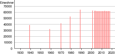
Population development
| 1939 | 1959 | 1970 | 1979 | 1989 | 2001 | 2005 | 2016 |
|---|---|---|---|---|---|---|---|
| 38,300 | 31,303 | 41,054 | 52,146 | 63,323 | 61,989 | 61.210 | 61.210 |
politics
Town twinning
-
 Andrychów , Poland
 -
Nysa , Poland
-
 Rădăuți , Romania
 -
Sighetu Marmației , Romania
-
 Drochia , Moldova
 -
 Mukachevo , Ukraine
 -
Mariupol , Ukraine
-
Bachmut , Ukraine
-
Kremenchuk , Ukraine
-
Chornomorsk , Ukraine
Culture and sights
Museums

There are four museums in Kolomyja that reflect the history and culture of the city and the region. Specifically, these are the National Museum of Folk Art of Hutsulia and Pokutia ( Musej narodnoho mysteztwa Huzulschtschyny ta Pokuttja im. J. Kobrynskoho, wul. Teatralna 25 ), the Museum of Easter Egg Painting ( Musej pysanskoho rospysu, prosp. W. Chornowola 43 ) Kolomyjas Museum. The local museum "Proswita" founded in 1986 in the wul. W. Blawazkoho 2 is based on a private initiative of the owner and only employee, the former biology teacher Roman Jaworskyj (born 1927). The museum, which according to its own advertising is accessible around the clock (Jaworskyj lives on the lower floor of the building), exhibits objects from different eras and regions, including a large number of coins, in three completely overcrowded rooms. Most of the exhibits, which are not annotated throughout , are everyday objects from the region.
Monuments
As in many other western Ukrainian cities, in Kolomyja after the collapse of the Soviet Union monuments were removed or rededicated and new ones were built for activists of the nationalist organizations. Instead of the Lenin monument on the Place of Rebirth (pl. Widrodschennja) there is now a seated Taras Shevchenko on the old plinth. There is also a bust of the poet in Shevchenko Park, and a plaque on Shevchenko Square commemorates a monument to the "Ukrainian Goethe" destroyed in 1914. The large facility for the fallen of the " Great Patriotic War" is now dedicated to the fighters (inscription) who died in the Second World War "for the freedom of Ukraine" - however, the year data have not been adapted to this new orientation: The numbers are still there 1941 and 1945 at the plant entrance. on the ramshackle concrete bases of the former revolution monument is now a carved marble fighters of the Ukrainian Insurgent army , which collaborated in the Second world war with the Germans. a bust of the leader of OUN-B , Stepan Bandera , is on the A memorial erected in 1967 commemorates the people murdered during the German occupation, without, however, specifying that most of the dead were Jews. A small memorial is dedicated to the inhabitants of Kolomyia who died in Afghanistan , the As in many other Ukrainian cities there are in Kolomyja a strongly religious Chernobyl monument (corner wul. Masepy / wul. W. Blawazkoho).
Others
The city is the namesake of the Ukrainian folk dance of the same name.
Economy and Infrastructure
The city is a railway junction and an agricultural trade center, also for trade with Central Europe . The city is home to the College of Law and Economics of the Kiev National University of Commerce and Economics .
sons and daughters of the town
- Krzysztof Beck (1930–1996), Polish weightlifter
- Edmund Bergler (1899–1962), Austrian-American psychoanalyst
- Wilhelm Friedrich Otto Bánkowski von Frugnoni (1867–1932), Lieutenant Field Marshal in the Austro-Hungarian Army.
- Jan Edgar (1847–1900), Austrian theater actor, theater director, writer and editor
- Andrij Fedtschuk (1980-2009), boxer
- Emanuel Feuermann (1902–1942), Austrian-German cellist
- Valery Dmitrievich Gassi (1948-2004), Soviet-Ukrainian handball player
- Mieczysław Jagielski (1924–1997), Polish politician
- Yossafat Kobrynskyj ( Йосафат Миколайович Кобринський ; 1818–1901), Ukrainian Greek Catholic priest, publicist, philanthropist, political and cultural activist
- Leo Kreindler (1886–1942), Austro-German editor and Jewish association official
- Philip Merlan (1897–1968), Austrian-American historian of philosophy
- Jan Ewangelista Nowicki (1894–1973), Bishop of Lemberg
- Dov Noy (1920–2013), Israeli folklorist
- Bohdan Osadczuk (1920–2011), Ukrainian journalist and political scientist
- Margit Sielska-Reich (1900–1980), Polish-Ukrainian painter
- Ephraim Fischel Rotenstreich (1882–1938), Polish Zionist politician
- Józef Sandel (1894–1962), art historian, art dealer and publicist
- Heinrich Süsskind (1895–1937), communist politician and journalist
Web links
- Historical information about the city (English)
- Historical map of the surrounding area (1662)
- Information about the Ghetto (1941–1944 )
- motlc.specialcol.wiesenthal.com 224 original pages , report by survivor Hermann Zenner, in the Simon Wiesenthal Center
Individual evidence
- ↑ a b population figures. In: pop-stat.mashke.org. 2019, accessed May 8, 2019 .
- ↑ Відповідно до Закону України "Про добровільне об'єднання територіальних громад" в Івано-Франківській області на територіях Коломийського, Надвірнянського районів
- ↑ Rizzi Zannoni, Woiewodztwo Ruskie, Część Krakowskiego, Sędomirskiego Bełzkiego y z y granicami Węgier, Polski, Które gory Karpackie nakształt łańcucha wyciągnione, od góry Wolska aż do Talabry, wyznaczaią .; 1772
- ^ Reichsgesetzblatt of October 8, 1850, No. 383, page 1741
- ^ PR Magocsi: Historical Atlas of Central Europe. University of Washington Press, Seattle 2002, p. 109.
- ↑ a b Aleksander Strojny, Krzystof Bzowski, Artur Grossmann: Ukraine - the West. 1st edition. Reise Know-How Verlag Peter Rump, 2008, p. 350.
- ↑ Societatea de Stiinte istorice şi din Republica Filologice Socialistă România "magazine istoric", Volume 29, Bucharest 1995, p. 11
- ↑ Florin Pintescu, Daniel Hrenciuc: Din istoria polonezilor în Bucovina: 1774–2002. Publishers Uniunea polonezilor din România, Suceava 2002, ISBN 973-0-02784-6 , p. 100.
- ↑ According to the provisions of the Ukrainian copyright law, which does not recognize freedom of panorama , the publication of photos of monuments is not possible without the permission of the respective artist, therefore the article cannot be illustrated in this area.
- ^ Structure. Regional subdivisions. In: knute.edu.ua. November 13, 2018, accessed May 8, 2019 .
Burschtyn | Bolekhiv | Dolyna | Halytsch | Horodenka | Ivano-Frankivsk | Yaremche | Kalush | Kolomyia | Kosiv | Nadwirna | Rohatyn | Snjatyn | Tlumatsch | Tysmenitsa
Bilzhivtsi urban-type settlements |
Bohorodchany |
Brochniv Ossada |
Bukachivtsi |
Bytkiw |
Delyatyn |
Hwisdez |
Jabluniw |
Jesupil |
Kuty |
Lanchyn |
Lyssez |
Obertyn |
Otynija |
Perehinske |
Pechenishyn |
Roshnyativ |
Sabolotiv |
Zolotvyn |
Chernelytsia |
Verkhovyna |
Voynyliv |
Vorokhta |
Wyhoda
