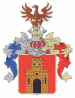
Gemer and Kleinhont county
|
Gömör and Kis-Hont county (Gemer and Kleinhont) (1910) |
|
|---|---|

|
|
| Administrative headquarters : | Rimaszombat |
| Area : | 4,278 km² |
| Population : | 188.098 |
| Ethnic groups : | 58% Magyars 38% Slovaks 2% Germans 2% other (gypsies) |

|
|
The County Gemer and small Hont (Hungarian Gömör és Kis-Hont vármegye , Slovak Gemersko-malohontská župa ) is the name of a historic administrative unit ( County / County ) in the Kingdom of Hungary , after 1918 briefly in Czechoslovakia and during the Second World War again in Hungary.
The county was established in 1802 through the merger of the Gemer county (Hungarian Gömör ) with the Kleinhont county ( Kishont Hungarian , Malohont in Slovak ) to form the Gemer and Kleinhont county ( Gömör és Kishont in Hungarian ).
The area is almost entirely in what is now southern Slovakia , a small part is in northern Hungary , the Slovak name Gemer is now used as the unofficial name for this area and as the official name of a tourist region.
location
County Gemer and small Hont bordered to the north by the County Liptov (Liptov / Liptó) , on the northeast by the County Zips (Spiš / Szepes) , to the east by the county Abaúj-Torna (Abov-Turňa) , on the southwest by the Borsod , in the south on a short section to Heves county , in the south-west to Neograd county (Novohrad / Nógrád) and in the north-west to Sohl county (Zvolen / Zólyom) .
So it was in the Slovak Ore Mountains roughly between today's Slovak-Hungarian border, the cities of Poltár and Rožňava and the Low Tatras (Slovak Nízke Tatry ). The area was traversed by the Slaná River ( Sajó in Hungarian ) and in 1910 there were 188,098 inhabitants in the county on an area of 4,278 km².
Administrative offices
Originally, the administrative center of the county was Gemer the castle Gemer in place Gemer (dt earlier. Also Gömmersburg, Gemersburg ) north of Tornaľa and from the beginning of the 18th century the place Plešivec . During the first unification of Kleinhont with Gemer to Gemer and Kleinhont in the years 1786-1790 Rimavská Sobota was the administrative seat, then again Plešivec and from 1850 then definitely Rimavská Sobota.
history
Gemer County was established by the beginning of the 12th century at the latest. Before that, it was part of Tornau County .
Between 1552 and 1687, almost the entire area was subject to tribute to the neighboring Ottoman Empire in the south (in present-day Hungary) and was subject to Turkish looting.
In the years 1786–1790 and 1802–1918 the county was united with the relatively small area between Tisovec and Rimavská Sobota , which was called Kleinhont . The combined county was then named Gemer and Kleinhont accordingly .
In 1918, most of the county (confirmed under international law by the Treaty of Trianon 1920) became part of the newly created Czechoslovakia , a small part around the town of Putnok remained with Hungary in the newly created county of Borsod-Gömör-Kishont (today's successor is Borsod-Abaúj-Zemplén ).
The southern half of the Czechoslovak part was occupied by Hungary as a result of the First Vienna Arbitration in 1938, where the Gömör és Kishont county was re-established. In Slovakia, which was independent from 1939–1945, the remaining part was part of the Hron County from 1940–1945 .
The borders were restored after the end of the Second World War in 1945, as was Czechoslovakia .
After the recent split of Czechoslovakia in 1993, the area came to an independent Slovakia and is now in the Banská Bystrica Region ( Banskobystrický kraj ) and in the Košice Region ( Košický kraj ). A small part around Vernár is part of the Eperies Regional Association ( Prešovský kraj ).
The administrative area of the county was incorporated chronologically as follows:
- 1918–1922: Gemersko-malohontská župa (Gemer-Kleinhont County), CS
- 1923–1928: Zvolenská župa (Alt-) Sohl County and Podtatranská župa (Tatra County), CS
- 1928–1939: Slovenská krajina / zem (Slovak Land), CS
- 1940–1945: Pohronská župa (Gran County), SK
- 1945–1948: Slovenská krajina (Slovak Country), CS
- 1949–1960: Banskobystrický kraj (Neusohl Regional Association) + Košický kraj (Kosice Regional Association) - not to be confused with today's, CS
- 1960–1990: Stredoslovenský kraj (Central Slovak Regional Association) + Východoslovenský kraj (East Slovak Regional Association), CS
- since 1996: Banskobystrický kraj (Neusohl Regional Association) + Prešovský kraj (Eperies Regional Association) + Košický kraj (Kosice Regional Association), SK
District subdivision
In the early 20th century the following chair districts existed (mostly named after the name of the administrative seat):
| Chair districts (járások) | |
|---|---|
| Chair district | Administrative headquarters |
| Feled (formerly Rimaszécs / Rimavská Seč ) | Feled, today Jesenské |
| Garamvölgy ("Grantal") | Nándorvölgy, today Vaľkovňa |
| Nagyrőce, today Revúca | Jolsva, today Jelšava |
| Putnok | Putnok |
| Ratkó | Ratkó, today Ratková |
| Rimaszombat | Nyustya, today Hnúšťa |
| Rozsnyó | Rozsnyó, today Rožňava |
| Tornalja | Tornalja, today Tornaľa |
| City districts (rendezett tanácsú városok) | |
| Dobsina, today Dobšiná | |
| Jolsva, today Jelšava | |
| Nagyrőce, today Revúca | |
| Rimaszombat, today Rimavská Sobota | |
| Rozsnyó, today Rožňava | |
See also
Web links
- Entry on the county in Meyers Konversationslexikon from 1888
- Entry in the Pallas Lexicon (Hungarian)
Individual evidence
- ↑ A magyar szent corona országainak 1910. évi népszámlálása . Budapest 1912, p. 12 ff.
- ↑ A magyar szent corona országainak 1910. évi népszámlálása . Budapest 1912, p. 22 ff. (1910 census)

