
Dechantskirchen
|
Dechantskirchen
|
||
|---|---|---|
| coat of arms | Austria map | |
 |
|
|
| Basic data | ||
| Country: | Austria | |
| State : | Styria | |
| Political District : | Hartberg-Fürstenfeld | |
| License plate : | HF (from 1.7.2013; old: HB) | |
| Surface: | 29.08 km² | |
| Coordinates : | 47 ° 25 ' N , 16 ° 1' E | |
| Height : | 531 m above sea level A. | |
| Residents : | 2.011 (January 1, 2020) | |
| Postal code : | 8241 | |
| Area code : | 03339 | |
| Community code : | 6 22 65 | |
| NUTS region | AT224 | |
| Address of the municipal administration: |
Dechantskirchen 34 8241 Dechantskirchen |
|
| Website: | ||
| politics | ||
| Mayoress : | Waltraud Schwammer ( ÖVP ) | |
|
Municipal Council : (2020) (15 members) |
||
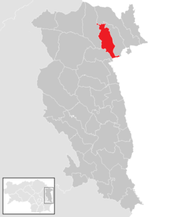
| Location of Dechantskirchen in the Hartberg-Fürstenfeld district | ||
  |
||

|
||
| Source: Municipal data from Statistics Austria | ||

Dechantskirchen is a municipality with 2011 inhabitants (as of January 1, 2020) in Austria and is located in the federal state of Styria , court district Fürstenfeld and in the political district Hartberg-Fürstenfeld . On January 1, 2015, Dechantskirchen was expanded to include a part ( cadastral municipality of Schlag) of the neighboring municipality of Schlag near Thalberg , which had existed until then, as part of the municipal structural reform .
geography
Geographical location
Dechantskirchen is located in the northeast of the Hartberg-Fürstenfeld district and also in Styria. The community is located approx. 15 km north of the district capital Hartberg . It lies at the foot of the foothills east of the Mur . The highest elevation in the municipality is the Hochkogel (1,314 m), the southernmost one-thousand-meter peak in the Wechsel . The municipality is crossed by some outflows of the change, which are all directly or indirectly tributaries of the Lafnitz .
Community structure
The community consists of the three cadastral communities Dechantskirchen, Hohenau, Kroisbach and Schlag or the following eight localities (residents as of January 1, 2020):
- Bergen (108) with the three houses squad
- Burgfeld (122) with Höttling
- Dechantskirchen (634)
- Hohenau am Wechsel (105) with the scattered settlement Jockl in the courtyard
- Kroisbach (394) with killer
- Limbach (25)
- Schlag bei Thalberg (390) with fiefdom and Thalberg settlement
- Stögersbach (233)
Incorporations
On January 1, 1967, the community of Hohenau am Wechsel was incorporated into Dechantskirchen.
Neighboring communities
| Sankt Lorenzen am Wechsel | Pinggau | Friedberg |
.svg)
|
Friedberg | |
| Rohrbach an der Lafnitz | Grafenschachen | Pinkafeld |
history

Due to the large number of standing menhirs and some known underground passages ( earth stables ), it can be assumed that there were human settlements as early as prehistoric times, i.e. 3000 to 1500 BC. In the municipality of Dechantskirchen.
Two tombstones, carved from marble, bear testimony to the settlement of the area around Dechantskirchen in Roman times, even if it is not much that the fragments walled in on the old cemetery wall east of the church reveal. The first passed down only the name of a certain Masculus MASCULO , the second was a tombstone for Calvisius, the son of Calventius CALVISIO CALVENTI (i filio). Both are the upper fragments of a stele and were found by the then chaplain Sales Prugger in 1846. The tombstone for Masculus is decorated with eagles, dolphins and palmettes. The second tombstone depicts a man in Roman clothing, a headless woman with a pomegranate and an armored soldier.
No structural remains have been preserved from the Slavs who immigrated at the end of the 6th century . At the end of the 8th century, the municipality became part of the Franconian Empire . However, it fell to the Hungarians at the end of the 9th century , before Henry III in 1043 . was recaptured. The community area first came to the Margraves of Wels-Lambach and soon to the Counts of Formbach and was until then a huge forest landscape.
The village of Dechantskirchen was first mentioned in a document in 1155, when Archbishop Eberhard I of Salzburg awarded the Admont Monastery two hubs. This written certificate of the place name reads "in villa Techanschirche". The name means a dean ( althd. Tëhhan) subordinate church . As early as 1163, the village came to Vorau Abbey on the occasion of its foundation by Margrave Ottokar III. As a result, the place changed hands frequently.
The village of Stögersbach is mentioned for the first time in 1396, while Kroisbach is mentioned for the first time as Chreuspach as early as 1381 . In the 14th century, the colonization of the municipality was completed.
Population development

Since 1981 there has been a negative migration balance , which was offset by a strongly positive birth balance until 2001 .
Culture and sights


Economy and Infrastructure
traffic
Dechantskirchen is located at Wechsel Straße B 54 and has a good connection to Hartberg in the south and Wiener Neustadt in the north as well as to the neighboring communities of Pinggau and Friedberg . The south autobahn A2 from Vienna to Graz can also be reached after about eight kilometers via the Friedberg-Pinggau junction (95).
In Dechantskirchen there is a train station for the thermal baths that has been downgraded to a stop . This offers regional train connections to Vienna and Hartberg every two hours .
Graz and Vienna airports are each approx. 100 km away.
politics
Municipal council
The last municipal council elections brought the following results:
| Political party | 2015 | 2010 1) | 2005 | 2000 | 1995 | 1990 | ||||||||||||
|---|---|---|---|---|---|---|---|---|---|---|---|---|---|---|---|---|---|---|
| St. | % | M. | St. | % | M. | St. | % | M. | St. | % | M. | St. | % | M. | St. | % | M. | |
| ÖVP | 933 | 67 | 10 | 955 | 65 | 2) | 599 | 52 | 8th | 632 | 61 | 9 | 739 | 68 | 10 | 672 | 62 | 9 |
| SPÖ | 342 | 24 | 4th | 456 | 31 | 2) | 445 | 39 | 6th | 411 | 39 | 6th | 353 | 32 | 5 | 414 | 38 | 6th |
| FPÖ | 123 | 9 | 1 | 56 | 4th | 2) | 98 | 9 | 1 | not running | not running | not running | ||||||
| voter turnout | 81% | 84% | 85% | 84% | 90% | 93% | ||||||||||||
1) The amalgamation of municipalities that has now taken place was reflected in the election results.
2) In the case of merged municipalities, the fictitious comparison vote shows the total number of votes from the original municipalities. Therefore, mandate comparisons are not possible.
mayor
Mayor is Waltraud Schwammer (ÖVP), Vice Mayor is Johann Zinggl (ÖVP).
coat of arms
With effect from November 1, 1974, the community of Dechantskirchen was awarded a coat of arms.
Blazon : "In a shield divided diagonally from green to silver, a golden ear of wheat crossed with a silver sickle in a pole, and a red crown with a green palm branch at the bottom."
Tourism association
Together with Friedberg, Pinggau and Schäffern, the community forms the “ Wechselland ” tourism association . Its seat is the municipality of Schäffern.
Personalities
Honorary citizen
The former community and today's cadastral community Hohenau am Wechsel has appointed the following honorary citizens:
- Pastor Alexander Mauerhofer, 1927
- District Captain Dr. Adolf Rochelt, 1932
- Otto von Habsburg (1912–2011), 1934
- Pastor Norbert Wurst, 1948
- Former Mayor Josef Groller, 1955
- District Captain Dr. Erwin Stibenegg, 1955
sons and daughters of the town
- Johann Reitmeier (1888–1977) came from Dechantskirchen and worked as a pastor and organizer in Treze Tílias (Dreizehnlinden), Brazil
Connected to the community
- Ottokar Kernstock (1848–1928), Austrian poet and priest, 1873–1889 chaplain in Dechantskirchen
- Reinhold Lopatka , ÖVP politician
Web links
- 62207 - Dechantskirchen. Community data, Statistics Austria .
Individual evidence
- ↑ Local council election 2020 - results Dechantskirchen. orf.at , accessed on August 22, 2020 .
- ↑ Section 5 (2) of the law of December 17, 2013 on the restructuring of the municipalities of the State of Styria ( Styrian Municipal Reform Act - StGsrG). Provincial Law Gazette for Styria of April 2, 2014. No. 31, year 2014. ZDB -ID 705127-x . Pp. 4-5.
- ↑ Statistics Austria: Population on January 1st, 2020 by locality (area status on January 1st, 2020) , ( CSV )
- ↑ Fritz Frhr. Lochner von Hüttenbach: On the name property of the early Middle Ages in Styria (= magazine of the Historical Association for Styria . Volume 99 ). Böhlau Verlag, Vienna 2008, p. 55 ( historerverein-stmk.at [PDF; 16.9 MB ]).
- ↑ A look at the community of Dechantskirchen. (PDF) Statistics Austria, accessed on June 19, 2020 .
- ↑ Archive link ( Memento of the original from September 28, 2007 in the Internet Archive ) Info: The archive link was inserted automatically and not yet checked. Please check the original and archive link according to the instructions and then remove this notice.
- ^ Grazer Zeitung , Official Gazette for Styria. December 30, 2014, 210th year, 52nd piece. No. 327. ZDB -ID 1291268-2 p. 632.
.svg)
Bad Blumau | Bad Loipersdorf | Bad Waltersdorf | Book-St. Magdalena | Burgau | Dechantskirchen | Ebersdorf | Feistritztal | Friedberg | Fürstenfeld | Grafendorf near Hartberg | Greinbach | Großsteinbach | Großwilfersdorf | Hartberg | Hartberg surroundings | Hartl | Ilz | Kaindorf | Lafnitz | Neudau | Ottendorf an der Rittschein | Pinggau | Pöllau | Pöllauberg | Rohr bei Hartberg | Rohrbach an der Lafnitz | Sankt Jakob im Walde | Sankt Johann in der Haide | Sankt Lorenzen am Wechsel | Shepherds | Söchau | Stubenberg | Advance | Waldbach-Mönichwald | Wenigzell