
Liquiçá (Municipality)
|
Munisípiu Likisá (tetum) Município de Liquiçá (port.) |
||
  |
||

|
||
| Data | ||
| Capital | Vila de Liquiçá | |
| surface | 559.92 km² (12.) | |
| Population (2015) | 71,927 (6.) | |
| Population density | 128.46 inhabitants / km² (3rd) | |
| Number of households (2015) | 11,885 (9.) | |
| ISO 3166-2: | TL-LI | |
| Administrative offices | Residents | surface |
| Bazartete | 27,879 | 197.02 km² |
| Liquiçá | 22,128 | 93.91 km² |
| Maubara | 21,920 | 268.99 km² |
| map | ||

|
||
Liquiçá ( tetum Likisá ; also Liquisa ) is a municipality in East Timor .
geography

The municipality of Liquiçá has an area of 559.92 km² since the regional reform in 2015 (before 550.95 km²). The capital of the municipality is Vila de Liquiçá , which has its center in Suco Dato , but extends beyond it. It has a total of 5152 inhabitants.
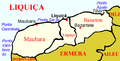
Liquiçá is located in the northwest of East Timor on the Sawu Sea . The Indonesian island of Alor is within sight . Liquiçá borders in the east on the municipality of Dili , in the southeast on Aileu , in the south on Ermera and in the west on Bobonaro . Liquiçá is divided into the three administrative offices Bazartete , Liquiçá and Maubara , which in turn are divided into 23 sucos.
In the center of the municipality, the land rises to over 1000 m , but falls back to the banks of the Lóis River , which forms the border with Bobonaro. The Lauveli flows into it , which is the border to Ermera's administrative offices Hatulia and Ermera . The highest point of the municipality is the Foho Cutulau ( Foho Kutulau ) in Bazartete with 1410 m . The nearby mountain Fatumasin ( 1369 m ) and its surroundings are a nature reserve and an important bird area . One of the three most important sanctuaries for orchids is also located here. The Maubara lake with its dry forests is also located in the municipality . At Bubble Beach in Suco Lauhata, volcanic gases escape from the ocean floor.
Most of the year the climate in Liquiçá is hot with high humidity, but little rainfall. Rain falls only in the rainy season between November and April. Most rivers only carry water during this time, but then they carry rock and earth with them. The only river in Liquiçá that carries water all year round is the Lóis, which is fed from the south. The relatively dry coastal plains have annual rainfall of 970 to 990 mm, in the mountains near Fazenda , Olivea and Algarve (administrative office Liquiçá) is reached 2143 to 2496 mm per year. In the low-lying areas, rain often falls briefly but heavily during storms, causing erosion and flooding in the lowlands. In Maumeta a maximum temperature of 32.5 ° C is measured in November and the lowest temperature 22.4 ° C in July.
Localities in Liquiçá

Road network and topography Liquiçás

Climate diagram of Liquiçá


Residents


71,927 inhabitants live in Liquiçá (2015, 2011: 66,613 inhabitants). The population density is 128.46 inhabitants per square kilometer. The administrative offices of Bazartete and Liquiçá are more densely populated than Maubara. The average age is 18.6 years. In Maubara in 2004 a woman had an average of 6.63 children, in Bazartete 8.45 and in Liquiçá 9.04 children (national average 6.99). Between 1990 and 2004 the number of inhabitants grew by 1.55% annually. In 2002, the infant mortality rate in Bazartete was 69 deaths per 1000 live births (1996: 103), in Maubara 94 (114) and in Liquiçá 104 (96). Liquiçá is one of 14 administrative offices in which it rose against the national trend. The national average was 98.
Several national languages are spoken as mother tongues in the community. 64.0% speak Tokodede (largest ethnic group in the administrative offices of Liquiçá and Maubara); 18.3% speak Mambai ; 16.4% speak Tetum , mostly Tetum Prasa (Administrative Office Bazartete). 0.4% speak Kemak and 0.2% speak Bunak . If the second languages are also taken into account, in 2015 94.5% spoke Tetum, 36.6% Bahasa Indonesia , 31.1% Portuguese and 13.8% English .
In 2004, 95.1% of the population were Catholics , 2.5% Protestants , 1.8% followers of the traditional, animistic religion of Timor and 0.1% each Muslim and Buddhist. The 2015 census recorded 96.96% Catholics, 2.41% Protestants, 0.29% Animists, 0.15% Muslims and 38 Buddhists.
In 2015, 34.4% of residents aged three or over attended school. 29.0% had left school. 35.2% have never attended school, which is 6% above the national average. 3.3% of Liquiçá's residents only attended pre-school, just under a third only attended primary school. Just under a quarter of the population have completed secondary schools. A diploma or a completed degree can show 3.5%, which corresponds to half of the national average. The illiteracy rate in 2015 was 23.0% (women: 24.1%; men: 21.9%). In 2004 it was 61.9%.
| Education | Graduation | ||||||||||
| at school | Finished school | never in a school | Preschool | primary school | Pre- secondary |
Secondary | Diploma / University of Applied Sciences |
university | No graduation | ||
| Women | 33.1% | 26.4% | 39.0% | 3.2% | 28.8% | 11.2% | 12.1% | 0.4% | 2.2% | 0.8% | |
| Men | 35.7% | 31.4% | 31.4% | 3.4% | 33.5% | 11.6% | 12.9% | 0.6% | 3.7% | 0.6% | |
| total | 34.4% | 29.0% | 35.2% | 3.3% | 31.1% | 11.4% | 12.5% | 0.5% | 3.0% | 0.7% | |
history
Prehistoric times and colonial times


Liquiçá, Maubara and Ulmera (Bazartete) were traditional Timorese empires ruled by a liurai . The empires appear on a list by Afonso de Castro , a former governor of Portuguese Timor who listed 47 empires in 1868. According to European sources, Liquiçá ruled east Timor together with Luca in the 16th century. Here Liquiçá is referred to as Likusaen . The name is derived from the old name "Liku Saen" , which means " Python ". Likusaen had its center in the area of the Tokodede and the Kemak, linguistically close to them, and also had an influence on the Bunak who lived south of them .
During the colonization of Timor, the area of today's Maubara administration office was occupied by the Netherlands in 1667 . In 1756 the Dutch built a fortress here . In the Treaty of Lisbon in 1859, the Dutch agreed to cede Maubara to the Portuguese as part of a major exchange of territory . The handover took place in April 1861.
During the rebellions in Portuguese Timor between 1860 and 1912 , the Liurai of Liquiçá was a loyal ally of the Portuguese colonial rulers , who several times provided troops to suppress the rebellions.
In the spring of 1861, one of the revolts of 1861 against Portuguese colonial rule broke out against forced labor on public projects in Ulmera . Governor Afonso de Castro struck them down in September of the same year.
In 1863 there was an uprising in Fatumasi . In the suppression, the Portuguese were supported here by the ruler of Ermera . In 1893 Maubara , along with Atabae , revolted against the expansion of military and administrative control over Portugal. After the outbreak of cholera , the Liurai had to officially sign a written contract with Portugal on Maubara's vassal status in November.
During the Second World War , Portuguese Timor was occupied by the Japanese ( see Battle for Timor ). In Liquiçá and Maubara, the entire remaining Portuguese population was interned in camps from the end of October 1942. After the surrender, the Portuguese took control of their colony again.
Indonesian occupation and UN administration

It was only after the Carnation Revolution of 1974 that East Timor should be prepared for independence. But when Indonesia began to occupy the regions near the border, FRETILIN unilaterally proclaimed independence in order to get international support. However, this did not materialize. Nine days after the declaration of independence, Indonesia began invading the rest of East Timor . At Ponta Tibar in Bazartete ended on December 7 heavy landing craft that places Liquiçá and Maubara were taken in June 1976th Indonesian soldiers massacred civilians near Maubara . By October 1976, almost the entire northern coast of Liquiçá was under Indonesian control. Large parts of the population fled from the invaders. The Malehui resistance base ( base de apoio ) was established in what is now the Maubara administrative office , where the civilian population who had fled from the FALINTIL resistance movement was settled. Other residents fled to the neighboring regions and as far as Manufahi . From September 1977 the Indonesian army began destroying the bases and occupying the last resistance areas in Liquiçá. People were dispersed or captured. Until February 1978 Liquiçá was completely in Indonesian hands. Between October 1977 and May 1978, the population in Liquiçá fell from 49,798 to 5,234, according to the Indonesian police. Statistics do not offer an official explanation for the population loss in such a short period of time.
On May 29, 1997, elections were held in which representatives of East Timor should be elected to the Indonesian parliament. Several attacks on the Indonesian occupying power and its supporters took place in the surrounding area. A hand grenade was thrown into the polling station in Açumanu . One soldier was wounded.
The district at that time was the scene of intimidation, rape and murder by pro-Indonesian militias as early as January 1999 during the unrest before and after the independence referendum . On January 19, the Besi Merah Putih (BMP) militia attacked Maubara, from which many residents fled. On April 5, the capital, Vila de Liquiçá, was attacked by the BMP. At least seven people died, 150 houses were burned down, and more than 1000 people sought refuge in the main church and the adjacent parish hall, where they were surrounded the next day by the militias Besi Merah Putih and Aitarak with the participation of Indonesian police and soldiers. In the following church massacre in Liquiçá , between 61 and 200 people died, depending on the source. On July 4, 1999, the pro-Indonesian militia Besi Merah Putih (BMP) attacked an aid convoy in Liquiçá, which was accompanied by UNAMET and UNHCR employees . Of the 77 people in the convoy, several local employees were seriously injured and the vehicles were destroyed with bars and stones. 62 members of the convoy escaped to the police station. Later they could return to Dili. Indonesian police officers and members of the secret service who were present did not intervene. On the contrary. One week after the incident, the Indonesian police began an investigation into a UN worker for alleged possession of weapons. On July 16, the BMP attacked the camp in Faulara and on July 18 on Vila de Liquiçá, whereupon people again fled into the mountains. Lissadila , Vatuvou and Maubaralissa became ghost towns. 6000 people fled to Sare (Ermera municipality), others to Dili and Liquiçá . Up to 5100 refugees gathered in Faulara (Suco Leotala ), a resettlement camp that had existed since 1996 and originally had 1,600 residents. Overall, it is estimated that 18,000 people fled the Liquiçá region before the referendum. At the end of July, around 9,000 refugees from Liquiçá returned to their hometowns despite the continued tense security situation in order to be able to take part in the referendum or to register in Dili. The day of the vote on August 30th was quiet, but after the announcement of the result on September 4th, in which the population clearly spoke out in favor of independence from Indonesia, another wave of violence broke out . In Fatumasi (Bazartete) 70 to 80% of the buildings were destroyed. Most of the buildings in the city of Liquiçá were also damaged. Overall, an estimated one third of the population of the then district was deported to Atapupu ( West Timor ) or fled to the surrounding hills. On September 20, the militias and Indonesian units finally began to withdraw from Liquiçá. On September 28, 1999, the first units of the international peacekeeping force INTERFET reached the district and restored peace and order. From October 4th, the United Nations began to establish an administration under UNTAET in the almost deserted region . On October 13th, an Australian infantry company was stationed in the deserted city of Liquiçá as security. Only gradually did the residents return. In 2002, East Timor finally gained its independence.

Liquiçá in independent East Timor
On May 24th, during the riots in East Timor in 2006 , fighting broke out between members of the East Timor’s Defense Forces and mutinous soldiers.
300 families were left homeless when floods ravaged the Sucos Maumeta (Bazartete), Dato and Luculai (Liquiçá) on January 1 and 2, 2008 . 100 houses were completely destroyed, 90 more damaged. The population was able to be evacuated by the national police in time, so that no people were harmed.
In 2014, the districts across East Timor were transformed into "parishes" and the sub-districts into "administrative offices".
politics

|
District President (Bupati) |
|
| Francisco dos Santos Ribeiro ( APODETI ) | May 1977-1984 |
| Jaime Remédios de Oliveira ( UDT ) | 1984-1989 |
| Gaspar Sarmento (UDT) | 1989-1994 |
| Leoneto Martins (APODETI) | 1994-1999 |
|
Administrador |
|
| Aurora Ximenes | around 2001 and 2003 |
| Leonel dos Santos | around 2007 |
| Domingos da Conceição dos Santos | current (as of 2014) |
The municipality's administrator is appointed by the state government in Dili. In 2001/2003 this was Aurora Ximenes, in 2007 Leonel dos Santos . The office is currently held by Domingos da Conceição dos Santos (as of February 2014).

In the elections to the constituent assembly , from which the national parliament later emerged, FRETILIN won 72.44% of the votes in Liquiçá, so that it received the direct mandate at that time. In the 2007 parliamentary elections , the Congresso Nacional da Reconstrução Timorense (CNRT) succeeded in becoming the strongest force in Liquiçá with 38.96% of the vote. In the parliamentary elections in 2012 , the CNRT was able to build on its success with 41.99% of the vote. In 2017 it only came to 32.2%, but remained the strongest force. In the early elections in 2018 , the Aliança para Mudança e Progresso (AMP) , to which the CNRT now belonged, received 47.5% of the vote.
In the 2007 presidential elections , the independent candidate and later election winner José Ramos-Horta in Liquiçá won the most votes in the first round. In the second round he received 87.8%. 2012 won Fernando de Araújo from the Partido Democrático (PD) in Liquiçá with 27%, but was beaten as the country in fourth place. The second round in Liquiçá went to the election winner Taur Matan Ruak with 64.2%. In the 2017 presidential elections , António da Conceição of the PD in Liquiçá won the most votes, but only finished second nationwide.
economy

.jpg)

-APiazza.JPG)
According to the 2010 census, 40% of all residents who are ten years or older work (national average: 42%). 5% are unemployed (5%). 76.9% of households practice arable farming, 92.2% cattle (as of 2010). Mainly maize (70% of households, production 2008: 1435 t), cassava (65%, 1520 t) and rice (5%, 465 t) are planted. The latter is mainly grown on the Lóis and Lauveli rivers. Many households also harvest vegetables (52%) and fruit (both together: 538 t) in their gardens. Most of the coconut and banana plantations were burned down during the 1999 riots. 61% of households now have coconut palms again. The most important commercial plant is coffee. Over 50% of the households in the community grow coffee. With over 6000 hectares of cultivation area, it is the fourth largest coffee producer in the country. Liquiçá relies on pure organic cultivation in its coffee production . After independence, the cultivation of vanilla began, among other things. The main domestic animals are chickens (47,554 in 84% of households), pigs (22,317 in 82% of households), goats (16,391 in 50% of households), cattle (8,018 in 32% of households), horses (1,492 in 9th % of households), buffalo (2,355 in 6% of households) and sheep (744 in 1% of households). The waters off Liquiçá are very rich in fish, so that it can also be caught for resale.
As large companies there is a factory for processing coffee and a poultry farm for egg production. A brick factory was established in Bazartete by aid organizations and an upholstery factory in Maubara. There are also three textile cooperatives. The goods are usually delivered to Dili, but now also to the neighboring municipalities of Ermera and Bobonaro.
In addition to remarkable buildings from the Portuguese colonial era, Liquiçá has black sandy beaches, coral reefs and attractive diving areas that make it attractive for tourism. Dili is close enough to make the community attractive for day and weekend trips, but there is often still a lack of suitable accommodation. There is a beach resort on Black Beach, east of Vila de Liquiçá. There are also some natural resources, such as gold .
The communal radio station Rádio Communidade Tokodede (RCT) broadcasts on FM 92.3 MHz. The FRETILIN radio station Radio Maetze can be received on FM 97.9 MHz.
environment

In addition to natural erosion, ongoing deforestation is exacerbating the problem, even if commercial logging is now prohibited across the country. For example, slash and burn is used to gain arable land. In addition, more frequent dry periods must be expected in the next few years due to climate change. A reforestation pilot project has started in Tibar.
Personalities
- Pascoela Barreto (* 1946), freedom activist and diplomat
- João Viegas Carrascalão (1945–2012), East Timorese politician
- Natália Carrascalão Antunes (* 1952), Portuguese politician and East Timorese diplomat
- António da Conceição (* 1964), politician
- Faustino da Costa (* 1974), policeman
- Hermenegildo da Cruz (* 1977), policeman
- Maria de Lourdes Martins Cruz (* 1962), nun and recipient of the Ramon Magsaysay Prize
- Calisto dos Santos (* 1959), officer
- Lídia Norberta dos Santos Martins (* 1980), politician
Partnerships
-
 Vila Nova de Poiares , Portugal (since 2000)
Web links
- District Profile 2013 (tetum, PDF file)
supporting documents
- Ministry of State Administration and Territorial Management
- Liquiçá District Development Plan 2002/2003 (English; PDF file; 367 kB)
Individual evidence
- ↑ a b c d e f g h i j k l m n o Direcção-Geral de Estatística : Results of the 2015 census , accessed on November 23, 2016.
- ↑ a b c Direcção Nacional de Estatística: 2010 Census Wall Chart (English) ( Memento of the original dated August 12, 2011 in the Internet Archive ) Info: The archive link was inserted automatically and has not yet been checked. Please check the original and archive link according to the instructions and then remove this notice. (PDF; 2.7 MB)
- ↑ Highlights of the 2010 Census Main Results in Timor-Leste English ( Memento of the original from September 28, 2013 in the Internet Archive ) Info: The archive link was inserted automatically and has not yet been checked. Please check the original and archive link according to the instructions and then remove this notice. (PDF; 4.5 MB)
- ↑ Mountains Mounts ( page no longer available , search in web archives ) Info: The link was automatically marked as defective. Please check the link according to the instructions and then remove this notice.
- ↑ Liquiçá District Development Plan 2002/2003 ( Memento of the original dated April 8, 2015 in the Internet Archive ) Info: The archive link was inserted automatically and has not yet been checked. Please check the original and archive link according to the instructions and then remove this notice. (English; PDF; 376 kB)
- ↑ Statistical Office of East Timor, results of the 2010 census of the individual sucos ( Memento of January 23, 2012 in the Internet Archive )
- ↑ Direcção Nacional de Estatística: Timor-Leste in figures 2011 (PDF; 3.8 MB) ( Memento of the original from February 19, 2014 in the Internet Archive ) Info: The archive link was inserted automatically and has not yet been checked. Please check the original and archive link according to the instructions and then remove this notice. , accessed May 5, 2013
- ↑ a b Census of Population and Housing Atlas 2004 ( Memento of November 13, 2012 in the Internet Archive ) (PDF; 14 MB)
- ↑ District Pritory Tables: Liquiçá 2004 ( Memento of the original from May 20, 2011 in the Internet Archive ) Info: The archive link was inserted automatically and has not yet been checked. Please check the original and archive link according to the instructions and then remove this notice. (PDF; 13 MB)
- ↑ TIMOR LORO SAE, Um pouco de história ( Memento of the original dated November 13, 2001 in the Internet Archive ) Info: The archive link was inserted automatically and has not yet been checked. Please check the original and archive link according to the instructions and then remove this notice.
- ↑ East Timor - PORTUGUESE DEPENDENCY OF EAST TIMOR ( Memento of February 21, 2004 in the Internet Archive )
- ↑ Suai Media Space: Koba Lima - Suai
- ↑ Antoinette Schapper: Finding Bunaq: The homeland and expansion of the Bunaq in central Timor ( Memento of the original from October 24, 2013 in the Internet Archive ) Info: The archive link was inserted automatically and has not yet been checked. Please check the original and archive link according to the instructions and then remove this notice. , P. 169, in: Andrew McWilliam, Elizabeth G. Traube: Land and Life in Timor-Leste: Ethnographic Essays , 2011.
- ↑ Schapper: Finding Bunaq , p. 170.
- ↑ a b c d History of Timor - Technical University of Lisbon ( Memento of the original from March 24, 2009 in the Internet Archive ) Info: The archive link has been inserted automatically and has not yet been checked. Please check the original and archive link according to the instructions and then remove this notice. (PDF; 824 kB)
- ↑ a b c d "Chapter 7.3 Forced Displacement and Famine" ( Memento of the original from November 28, 2015 in the Internet Archive ) Info: The archive link was inserted automatically and has not yet been checked. Please check the original and archive link according to the instructions and then remove this notice. (PDF; 1.3 MB) from the "Chega!" Report by CAVR (English)
- ↑ (INDONESIA-L) HRW / ASIA - East Timor Guerrilla Attacks: East Timor Guerrilla Attacks of June 4, 1997 ( Memento of September 19, 2006 in the Internet Archive )
- ↑ ETAN : July 4 Militia Attack on the Humanitarian Team in Liquiça: Another Slap in the Face to the UN (Summer 1999) ISSN 1088-8136
- ↑ Relief Web, January 7, 2008, Timor-Leste: Humanitarian update, Dec 21 - Jan 7, 2008
- ↑ "Part 4: Regime of Occupation" ( Memento of the original from January 18, 2012 in the Internet Archive ) Info: The archive link was inserted automatically and has not yet been checked. Please check the original and archive link according to the instructions and then remove this notice. (PDF) from the "Chega!" Report by CAVR (English)
- ^ Timor-Leste, Eleições Gerais 2012 by STAE Informação Pública. Archived from the original on December 26, 2015 ; accessed on January 23, 2016 .
- ↑ World Bank: Participation List Timor-Leste and Development Partners Meeting 3-5 December 2003 , accessed April 27, 2020.
- ↑ Timor-Leste 'Work for Peace' Project Projetu Serbisu Ba Dame, December 2007 ( Memento from February 22, 2014 in the Internet Archive ) (PDF; 4.7 MB)
- ↑ Descentralização Administrativa na República Democrática de Timor-Leste: Liquiçá , accessed on February 7, 2014
- ↑ Lurdes Silva-Carneiro de Sousa: Some Facts and Comments on the East Timor 2001 Constituent Assembly Election ( Memento of October 16, 2013 in the Internet Archive ) ( RTF ; 199 kB), Lusotopie 2001: pp. 299–311.
- ↑ CNE - official results on 9th July 2007 ( Memento from September 27, 2007 in the Internet Archive ) (PDF; 118 kB)
- ↑ CNE: CNE 2017
- ↑ CNE: Munisipios , accessed May 30, 2018.
- ↑ a b Direcção Nacional de Estatística: Suco Report Volume 4 (English) ( Memento of the original from April 9, 2015 in the Internet Archive ) Info: The archive link was inserted automatically and has not yet been checked. Please check the original and archive link according to the instructions and then remove this notice. (PDF; 9.8 MB)
- ↑ Direcção Nacional de Estatística: Timor-Leste in Figures 2008 ( Memento of the original of July 7, 2010 in the Internet Archive ) Info: The archive link was inserted automatically and has not yet been checked. Please check the original and archive link according to the instructions and then remove this notice. (PDF; 3.7 MB)
- ↑ ARKTL - Asosiasaun Radio Komunidade Timor-Leste (English)
- ↑ Municípios Portugueses: Geminações de Cidades e Vilas , accessed on January 7, 2018.
Coordinates: 8 ° 35 ′ S , 125 ° 21 ′ E
The administrative borders within East Timor changed in 2015. This article must therefore be checked and updated if necessary. See New Administrative Boundaries .