
Ravenel (Oise)
| Ravenel | ||
|---|---|---|

|
|
|
| region | Hauts-de-France | |
| Department | Oise | |
| Arrondissement | Clermont | |
| Canton | Saint-Just-en-Chaussée | |
| Community association | Picard plateau | |
| Coordinates | 49 ° 31 ' N , 2 ° 30' E | |
| height | 88-135 m | |
| surface | 11.61 km 2 | |
| Residents | 1,098 (January 1, 2017) | |
| Population density | 95 inhabitants / km 2 | |
| Post Code | 60130 | |
| INSEE code | 60526 | |
| Website | http://www.ravenel.fr/ | |
,_mairie.JPG) Town Hall (Mairie) by Ravenel |
||

Ravenel is a French commune with 1,098 inhabitants (as of January 1 2017) in the department of Oise in the region of Hauts-de-France (before 2016: Picardie ). The municipality is part of the Arrondissement Arrondissement Clermont and is part of the canton of Saint-Just-en-Chaussée . The inhabitants are called Ravenellois .
Ravenel is part of the Communauté de communes du Plateau Picard .
geography
Ravenel is about 31 kilometers east-northeast of Beauvais . Ravenel is surrounded by the neighboring communities of Maignelay-Montigny in the north, Saint-Martin-aux-Bois in the east and northeast, Léglantiers in the east and southeast, Angivillers in the south, Le Plessier-sur-Saint-Just in the west and Plainval in the northwest.
Population development
| 1962 | 1968 | 1975 | 1982 | 1990 | 1999 | 2006 | 2013 | |
|---|---|---|---|---|---|---|---|---|
| 903 | 898 | 880 | 901 | 909 | 1,018 | 1,114 | 1,139 | |
| Sources: Cassini and INSEE | ||||||||
Attractions
- Notre-Dame church from the 16th century, Monument historique since 1919 (see also: List of Monuments historiques in Ravenel (Oise) )
- chapel
- Ravenel Castle from the 16th century
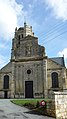
Notre-Dame church

lock
.JPG)
,_ch%C3%A2teau,_rue_du_Ch%C3%A2teau.JPG)