Saint-Georges (Cantal)
|
Saint-Georges Sant Georges |
||
|---|---|---|
|
|
||
| region | Auvergne-Rhône-Alpes | |
| Department | Cantal | |
| Arrondissement | Saint-Flour | |
| Canton | Neuvéglise | |
| Community association | Saint-Flour Community | |
| Coordinates | 45 ° 1 ′ N , 3 ° 8 ′ E | |
| height | 740-1,001 m | |
| surface | 33.14 km 2 | |
| Residents | 1,177 (January 1, 2017) | |
| Population density | 36 inhabitants / km 2 | |
| Post Code | 15100 | |
| INSEE code | 15188 | |
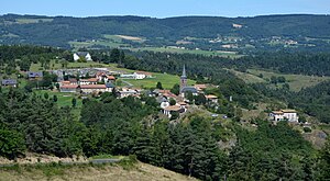
 View of Saint-Georges |
||
Saint-Georges ( Occitan : Sant Georges ) is a central French city and a municipality with 1177 inhabitants (as of January 1 2017) in the Cantal in the region of Auvergne Rhône-Alpes . The municipality belongs to the arrondissement of Saint-Flour and the canton of Neuvéglise (until 2015: canton of Saint-Flour-Nord ).
location
Saint-Georges is located about 55 kilometers east-northeast of Aurillac am Ander . Saint-Georges is surrounded by the neighboring communities of Coren and Mentières in the north, Tiviers in the northeast, Vabres in the east, Ruynes-en-Margeride in the east and southeast, Anglards-de-Saint-Flour in the south and southeast, Alleuze in the south and southwest as well Saint-Flour to the west.
The A75 autoroute runs through the municipality .
Population development
| year | 1962 | 1968 | 1975 | 1982 | 1990 | 1999 | 2006 | 2013 |
| Residents | 762 | 774 | 893 | 1,036 | 1,039 | 939 | 1,128 | 1,116 |
| Source: Cassini and INSEE | ||||||||
Attractions
- Mons dolmen, historic monument since 1980
- Chausse Tumuli, Monument historique since 2010
- Varilettes Castle, Monument historique since 1982


