
Saint-Pierre-d'Entremont (Orne)
| Saint-Pierre-d'Entremont | ||
|---|---|---|
|
||
| region | Normandy | |
| Department | Orne | |
| Arrondissement | Argentan | |
| Canton | Flers-1 | |
| Community association | Domfront Tinchebray Interco | |
| Coordinates | 48 ° 49 ′ N , 0 ° 39 ′ W | |
| height | 106-216 m | |
| surface | 6.19 km 2 | |
| Residents | 687 (January 1, 2017) | |
| Population density | 111 inhabitants / km 2 | |
| Post Code | 61800 | |
| INSEE code | 61445 | |
| Website | http://www.saint-pierre-d-entremont.fr/ | |
 Town hall (Mairie) of Saint-Pierre-d'Entremont |
||

Saint-Pierre-d'Entremont is a French municipality with 687 inhabitants (at January 1, 2017) in the department of Orne in the region Normandy (before 2016 Basse-Normandie ). The municipality belongs to the Arrondissement of Argentan and the canton of Flers-1 (until 2015 Tinchebray ). The inhabitants are called Entremontais .
geography
Saint-Pierre-d'Entremont is about 55 kilometers south-southwest of Caen . Saint-Pierre-d'Entremont is surrounded by the neighboring communities of Moncy in the north and north-west, Condé-en-Normandie in the north-east, Caligny in the east, Cerisy-Belle-Étoile in the south and south-east and Montsecret-Clairefougère in the south and west.
Population development
| year | 1962 | 1968 | 1975 | 1982 | 1990 | 1999 | 2006 | 2011 | 2016 |
| Residents | 625 | 558 | 527 | 585 | 597 | 677 | 696 | 712 | 700 |
| Source: Cassini and INSEE | |||||||||
Attractions
- Saint-Pierre-et-Saint-Paul church from the 18th century
- Mill Les Rochettes on Noireau
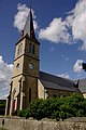
Saint-Pierre-et-Saint-Paul church

Les Rochettes Mill


Web links
Commons : Saint-Pierre-d'Entremont - Collection of images, videos and audio files