Trouville
| Trouville | ||
|---|---|---|

|
|
|
| region | Normandy | |
| Department | Seine-Maritime | |
| Arrondissement | Le Havre | |
| Canton | Notre-Dame-de-Gravenchon | |
| Community association | Caux Seine agglo | |
| Coordinates | 49 ° 34 ' N , 0 ° 36' E | |
| height | 135-154 m | |
| surface | 10.38 km 2 | |
| Residents | 632 (January 1, 2017) | |
| Population density | 61 inhabitants / km 2 | |
| Post Code | 76210 | |
| INSEE code | 76715 | |
| Website | http://trouville76.free.fr | |
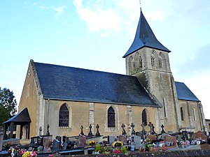
 Notre-Dame church |
||
Trouville , often Trouville-Alli Querville called, is a French municipality with 632 inhabitants (at January 1, 2017) in the department of Seine-Maritime in the region Normandy .
geography
Trouville is located in the Pays de Caux , 43 kilometers east of Le Havre .
history
The parish consists of the two villages of Trouville and Alliquerville .
The name Trouville is derived from the Anglo-Scandinavian name Torold , a variant of the Norwegian Thorwald and the Old French word ville , farm (Latin villa rustica ), then village. The Latinized form Thorouvilla , documented for 1240 , finally became Trouville .
The derivation from the name Torold applies to the place names Thérouldeville , Turretot , Bourgtheroulde and the other places called Trouville in Normandy.
The name Alliquerville is derived from Alichervilla , 1111–1118, the farm of Alitcharius ( Alitkar ). The latter is a Germanic two-part personal name with the components alit and kar .
| Population development | |||||||
|---|---|---|---|---|---|---|---|
| year | 1962 | 1968 | 1975 | 1982 | 1990 | 1999 | 2009 |
| Residents | 374 | 404 | 415 | 501 | 537 | 563 | 603 |
Parish partnership
Trouville maintains a partnership with the Bad Essen district of Hüsede .
Personalities
- Jacques Bouteloup (1918-2010), mathematician
Individual evidence
- ^ François de Beaurepaire, Les Noms des communes et des anciennes paroisses de la Seine-Maritime , Editions Picard, 1979, publié avec le soutien du CNRS .
