
Étretat
| Étretat | ||
|---|---|---|

|
|
|
| region | Normandy | |
| Department | Seine-Maritime | |
| Arrondissement | Le Havre | |
| Canton | Octeville-sur-Mer | |
| Community association | Canton de Criquetot-l'Esneval | |
| Coordinates | 49 ° 42 ' N , 0 ° 12' E | |
| height | 0-102 m | |
| surface | 4.07 km 2 | |
| Residents | 1,291 (January 1, 2017) | |
| Population density | 317 inhabitants / km 2 | |
| Post Code | 76790 | |
| INSEE code | 76254 | |
| Website | http://www.etretat.net/ | |
 Étretat from the rock path to the Porte d'Aval |
||

Etretat is a commune and a seaside resort with 1,291 inhabitants (at January 1, 2017) in the Seine-Maritime department in the region of Normandy . Étretat is best known for the steep rock cliffs with their extraordinary rock formations that frame the place on both sides. The place is geared towards tourism with hotels, restaurants, souvenir shops and a wide range of leisure and sports activities.
Geography and geology

Étretat is located at sea level directly on the English Channel in one of the few valley openings in the 120 km long cliff between Dieppe and Le Havre , which is called the Alabaster Coast because of its light color . The tidal range is, as everywhere in Normandy, considerable.
The Étretat cliffs were formed in the Upper Cretaceous . They essentially consist of white chalk and flint . Other minerals that are common on the coast of eastern Normandy are not found at Étretat. There you can find neither the sandstone that occurs in the north of the department in the Dieppe area, nor the yellowish oolite from the Caen area .
At Fécamp , a little further north, you will find the highest cliffs of this type with a height of 105 m. The Falaises d'Aval southwest of Étretat are 75 m high, the Falaises d'Amont to the east are 84 m high. Underneath the cliffs there is rubble that comes from the crash of large boulders. The erosion from rainwater penetrating the porous chalk and frost promote this decay. At the base, the sea surf erodes the rock.
The chalk is dissolved in the sea water and washed away. The flint deposited in layers remains underneath the rocks. It is ground into round pebbles in the surf. These form the characteristic pebble beaches on the Alabaster coast. Fresh water and ice erosion has a stronger impact than that of the sea. This can be seen on the pebble beaches in the Seine valley , where the sea does not play a role.
The three distinctive rock arches Porte d'Amont , Porte d'Aval and Manneporte owe their formation to the surf and not to a river that would have run parallel to the current coastline, as is often incorrectly depicted. The Aiguille rock needle is made of somewhat harder limestone, which has withstood this retrograde erosion to this day. Another well-known formation is the Pointe de la Courtine .
Place name
Contrary to older sources, the name Étretat is neither of Latin nor Gallo-Roman origin. It is probably an Old Norse name. Such names are particularly common in this region of Normandy.
The place was first mentioned as Strutat around 1040 . This name can also be found in sources from the 12th to the 15th century, regularly mentioned as Estrutat and Estrutart . Other forms such as Estretot and Estretal only appeared sporadically and were probably spelling mistakes .
The first part of the name can be found in Eturville ( department Manche , 1165 Sturvilla ), in Étreville ( department Eure , 1054 Sturivilla , 1148 Esturvilla ) and in Eturqueraye (department Eure, next to Étreville). It is probably the Scandinavian male given name Styri or Sturi . It can be found in the family name Estur , which is still common in the Pays de Caux . In the old Norman technical name esturman ( man of the steering , pilot), which has been Latinized as Strumannus , the same phonetic development is found. This word is mentioned for the first time in the Cartulaire de Jersey and it derives from the Old Norse stýrimaðr .
The second element is possibly Old Norse stadr , place.
Another interpretation says that the first part of the name is derived from the personal name Thor , Thori , as in the Norman places called Tourville . In this case there are two metatheses : * Thorstadr to * Stortat / * Sturtat and finally to Strutat 1040. These metatheses are particularly common in the dialect of the Pays de Caux , the Cauchois .
history
Beginnings
Archaeological finds show that the place was settled in ancient times. However, no details are known about the importance of the place or the life of its inhabitants in antiquity. Even the ancient name has not been passed down.
With the city of Iuliobona , Lillebonne , the place was connected by a Roman road. Several objects from the Gallo-Roman period have survived to the present day: a three kilometer long aqueduct , the upper half of which was destroyed in the 19th century, coin finds, vessels, a villa rustica , a grave site for cremations with a few urns made of terracotta , red Earthenware plates and iron nails. The Abbé Cochet exhumed four other tombs with 18 vases. As elsewhere, these finds of Roman civilization do not clearly prove the presence of Romans, but rather the gradual change of the Celtic population, in this case the Caleti , to the Roman way of life. This change was driven by the own elites of this population. From the period up to around 200 AD, no Roman military grave and no field camp have been discovered in the entire north-west of Gaul.
In the jardin du presbytère , the presbyter garden , there is a cemetery from the Merovingian period. Among other things, some Roman soldiers' graves were moved there at that time. They contained a spathe , clasps of bronze, centurions -Schilde and a Scramasax and a dozen skeletons in a sitting position. Other burial sites contained flint objects at the feet of the buried, three scramasaxes, clasps and shields made of inlaid iron, bony needles and other objects. The excavated objects and the weapons finds, the distribution of which was limited to graves, point to Franconians or Saxons who settled there, similar to Frénouville or Vron . Just like the Celts, the Germans also assimilated to the Roman way of life.
Oyster park
The oyster park was built in 1777, supposedly for Queen Marie Antoinette . The oysters farmed did not come from Étretat itself, but were brought in by two boats ( Syrène and Cauchoise ) from Cancale , 100 million oysters a year. These stayed here for a few months, alternately in salt and fresh water, which should serve to refine the taste. Then they were transported on to Paris .
19th century

For Étretat, the 19th century meant the transition from a traditional fishing village to a seaside resort. The plan to build a naval port there, which had already been considered by Francis I to Napoleon Bonaparte , was finally abandoned during this time. Up until the middle of the 19th century there were no fewer than 25 to 30 fishing trawlers on the Perrey , the beach bulwark. Then their number quickly decreased until there was only one left. They were replaced by small boats used to fish near the coast. Clinques , ships with traditional clinker cladding , went to Dieppe to fish for herring. Towards the end of autumn the village consisted of 250 to 300 sailors. At the end of the century, the mackerel was the only significant catch left to be hunted during the three summer months.
The inaccessibility of the place made the construction of telegraph and telephone lines difficult. Due to the sandless pebble beach, Étretat remained less successful as a seaside resort than Trouville-sur-Mer or even Dieppe or Le Havre . The development of tourism only got going after 1843. Alphonse Karr , who wrote a successful novel about the place, contributed greatly to its popularity. At that time the roads to Fécamp and Le Havre were built. Regular connections with horse-drawn buses were established. Finally, in 1890, a railway line and a train station released the town, which was already known as summer resort, from its isolation.
Large villas in the style that prevailed in the seaside resorts were built in ever increasing numbers. The place itself was also largely rebuilt, with houses made of hewn flint and bricks. A casino house made of wood and slate opened in 1852. It was operated by the newly established Société des Bains de mer d'Étretat . stage performances such as Orpheus in the Underworld by Jacques Offenbach took place in it. The composer owned a villa in Étretat, which he named after this comic opera .
20th century

After the First World War , when living conditions and means of transport improved and paid holidays became common, tourism increased sharply. Due to the dense settlement, the water quality, the biodiversity and even the air quality decreased. A large number of artists, intellectuals and politicians who had previously visited the place now avoided this place of mass tourism. The Second World War put an end to this growth. The German occupiers rebuilt the seashore and even tore down the casino and villas in favor of fortifications. After the war, the sea facade was rebuilt in a controversial manner. In the 2000s, the reconstruction work on the Perrey seafront and the rebuilding of the casino were completed.
The place became more and more a destination for international tourism. The chalk cliffs of Étretat became famous through the paintings of Claude Monet and Gustave Courbet . The proximity to Paris, Rouen and Le Havre also encouraged the influx of international audiences. Nevertheless, there are still the traditional summer visitors. These holidaymakers often come from the Paris region. Many have owned homes for generations and are friends with the local people.
In the town's narrow streets, traffic and pedestrians and cars togetherness became a problem, especially on weekends and during the summer holidays. To reduce traffic, the city council installed large parking lots on rue Guy de Maupassant , near the small Protestant church and opposite the Germaine Coty retirement home . In the recent past, another large car park was built on route du Havre .
In 1990 the last professional fisherman gave up his trade.
Legends and incidents
Olive's fountain
At the time of the Great Migration, a young woman named Olive was washing her clothes in a beach fountain when she found herself surrounded by a horde of Vikings . She prayed to God for salvation from their hands and vowed to build a church. A storm came up and the Viking boats were pushed back into the sea. Olive decided to build the church on the beach. But the devil carried the stones brought for it to the foot of the Saint-Clair hill , and so the church was built in its current location.
The Chambre des Demoiselles
One day three young women were kidnapped by the Lord of Fréfossé and locked in a grotto, the Chambre des Demoiselles . However, since they refused to accept him, they were walled up alive. They remained like this for three days and three nights, and fishermen heard their wailing until it died out. Then an old woman saw three angel shapes rising to heaven from the beach.
The Indian prince
The Indian prince Bapu Saheb Gatjay spent the summer of 1884 in Étretat together with his son-in-law and his entourage before continuing to Oxford . However, despite medical treatment, he succumbed to illness within a few days. According to the Hindu rite, the body should be cremated; the then mayor of Étretats Adolphe Boissaye was asked for permission. He telegraphed this to the prefect of the département at eight o'clock in the evening, i.e. after work, and made it clear that the ceremony would take place the following night if there was no answer. When there was no response at midnight, the body was taken to the city and hastily burned at a stake two hours later. At dawn there were only a few bones left, at six in the morning there were no traces at all. When the news got out, townspeople rushed to the beach but found only blackened pebbles. The same morning a telegram from the Prefect arrived: "Cremation is strictly prohibited".
politics
| Period | Surname | Political party | job | |
|---|---|---|---|---|
| 1961 | 1965 | Françoise Lieury | ||
| 1965 | 1971 | Henri Collin | ||
| 1971 | 2001 | Henri Dupain | ||
| 2001 | 2005 | Monique Chevessier-Xiberas | ||
| 2005 | 2008 | Jean-Bernard Chaix | ||
| 2008 | Franck Cottard | |||
coat of arms
|
|
Étretat |
population
| year | 1968 | 1975 | 1982 | 1990 | 1999 | 2008 | ||||||||||||||||||||||||||||||||||||||||||||||||||||||||||||||||||||||||||||||||||||||||||||||||||||||||||||||||||||||||||||||||||||||||||||||||||||||||||||||||||||||||||||||||||||||||||||||||||||||||||||||||||||||||||||||||||||||||||||||||||||||||||||||||||||||||||||||||||||||||||||||||||||||||||||||||||||||||||||||||||||||||||||||||||||||||||||||||||||||||||||||||||||||||||||||||||||||||||||||||||||||||||||||||||||||||||||||||||||||||||||||||||||||||||||||||||||||||||||||||||||||||||||||
|---|---|---|---|---|---|---|---|---|---|---|---|---|---|---|---|---|---|---|---|---|---|---|---|---|---|---|---|---|---|---|---|---|---|---|---|---|---|---|---|---|---|---|---|---|---|---|---|---|---|---|---|---|---|---|---|---|---|---|---|---|---|---|---|---|---|---|---|---|---|---|---|---|---|---|---|---|---|---|---|---|---|---|---|---|---|---|---|---|---|---|---|---|---|---|---|---|---|---|---|---|---|---|---|---|---|---|---|---|---|---|---|---|---|---|---|---|---|---|---|---|---|---|---|---|---|---|---|---|---|---|---|---|---|---|---|---|---|---|---|---|---|---|---|---|---|---|---|---|---|---|---|---|---|---|---|---|---|---|---|---|---|---|---|---|---|---|---|---|---|---|---|---|---|---|---|---|---|---|---|---|---|---|---|---|---|---|---|---|---|---|---|---|---|---|---|---|---|---|---|---|---|---|---|---|---|---|---|---|---|---|---|---|---|---|---|---|---|---|---|---|---|---|---|---|---|---|---|---|---|---|---|---|---|---|---|---|---|---|---|---|---|---|---|---|---|---|---|---|---|---|---|---|---|---|---|---|---|---|---|---|---|---|---|---|---|---|---|---|---|---|---|---|---|---|---|---|---|---|---|---|---|---|---|---|---|---|---|---|---|---|---|---|---|---|---|---|---|---|---|---|---|---|---|---|---|---|---|---|---|---|---|---|---|---|---|---|---|---|---|---|---|---|---|---|---|---|---|---|---|---|---|---|---|---|---|---|---|---|---|---|---|---|---|---|---|---|---|---|---|---|---|---|---|---|---|---|---|---|---|---|---|---|---|---|---|---|---|---|---|---|---|---|---|---|---|---|---|---|---|---|---|---|---|---|---|---|---|---|---|---|---|---|---|---|---|---|---|---|---|---|---|---|---|---|---|---|---|---|---|---|---|---|---|---|---|---|---|---|---|---|---|---|---|---|---|---|---|---|---|---|---|---|---|---|---|---|---|---|---|---|---|---|---|---|---|---|---|---|---|---|---|---|---|---|---|---|---|---|---|---|---|---|---|---|---|---|---|---|---|---|---|---|---|---|---|---|---|---|---|---|---|---|---|---|---|---|---|---|---|---|---|---|---|---|---|---|---|---|---|---|
| Residents | 1,472 | 1,525 | 1,577 | 1,565 | 1,615 | 1,505 | ||||||||||||||||||||||||||||||||||||||||||||||||||||||||||||||||||||||||||||||||||||||||||||||||||||||||||||||||||||||||||||||||||||||||||||||||||||||||||||||||||||||||||||||||||||||||||||||||||||||||||||||||||||||||||||||||||||||||||||||||||||||||||||||||||||||||||||||||||||||||||||||||||||||||||||||||||||||||||||||||||||||||||||||||||||||||||||||||||||||||||||||||||||||||||||||||||||||||||||||||||||||||||||||||||||||||||||||||||||||||||||||||||||||||||||||||||||||||||||||||||||||||||||||
| From 1962 official figures excluding residents with a second residence | ||||||||||||||||||||||||||||||||||||||||||||||||||||||||||||||||||||||||||||||||||||||||||||||||||||||||||||||||||||||||||||||||||||||||||||||||||||||||||||||||||||||||||||||||||||||||||||||||||||||||||||||||||||||||||||||||||||||||||||||||||||||||||||||||||||||||||||||||||||||||||||||||||||||||||||||||||||||||||||||||||||||||||||||||||||||||||||||||||||||||||||||||||||||||||||||||||||||||||||||||||||||||||||||||||||||||||||||||||||||||||||||||||||||||||||||||||||||||||||||||||||||||||||||||||||
In 1793 Étretat had 925 inhabitants. After the population grew to 1591 in 1836, it fell to 1014 in 1841. After that, it rose steadily, reaching its peak in 1886 at 2131. It then remained at around 2000 inhabitants, after the First World War it was a little less. Since 1962, residents with a second residence are no longer counted; since then the population has leveled off at around 1500.
economy
The most important branch of the economy in the area is tourism. Together with the Palais Bénédictine in Fécamp , the Cathedral of Rouen and the Claude Monet House and Garden in Giverny , Étretat is one of the four most visited tourist destinations in Upper Normandy .
coast
Ark and Aiguille

Erosion has formed a natural arch, the ark , also known as the Porte d'Aval (elephant's trunk), and the Aiguille rock needle .
Maurice Leblanc described them as follows:
"Roc énorme, haut de plus de quatre-vingts mètres, obélisque colossal, d'aplomb sur sa base de granite"
"Huge rock, more than eighty meters high, colossal obelisk, perpendicular to its granite foundation"
Even during Leblanc's lifetime, the place attracted many tourists, including the lupinophiles : admirers of Leblanc's fictional character Arsène Lupine , American students who wanted to find the entrance to the cave where the gentleman burglar had found the key to the treasure of the kings of France . The film Arsène Lupine - The King Among Thieves offers numerous panoramic views of the Falaise d'Aval and the Aiguille .
Manneporte

The name Manneporte comes from the old French manne porte , large gate. Manne , from Latin magnum or magna , can be found again in place names such as Manéglise and Mandeville . The Manneporte is located southwest of the Valleuse de Jambourg and the Porte d'Aval and is larger than them. Between Manneporte and the Pointe de la Courtine located southwest of it, the source of Les Pisseuses rises directly from the steep bank.
Falaise d'Amont
.jpg)
The Porte d'Amont is the smallest of the three rock gates.
On the summit above the cliff rises the chapel of Notre-Dame-de-la-Garde , patron saint of sailors. The predecessor of today's chapel was built in the 19th century in neo-Gothic style and blown up by the German occupiers. There is also a small museum on the rock, built by the architect Gaston Delaune, and the Nungesser and Coli monument . It is dedicated to the pilots Charles Nungesser and François Coli , who went missing while trying to fly over the Atlantic in 1927.
Beach and rock path

Surrounded by cliffs, the beach is well protected from the prevailing winds. In summer it is lively and takes on the character of a fairground, only to come back to its rough and grandiose character in winter. It is tiresome to walk on the pebbles.
However, they are an important protection against the waves by dampening their force. It is therefore forbidden to take beach pebbles with you. However, they are transported northwards by the natural ocean currents. Once upon a time there were horses on the beach, loaded with baskets full of collected beach pebbles. The silicate-rich stones were mainly sold to porcelain, ceramic and glass factories.
Between the beach and the village there is a dam that also serves as a promenade; he is called Perrey or Perré . This dialect expression means covered with gravel . It originally only referred to the section of the beach from which the boats were launched. The dam is necessary to protect the place from storm surges.
At the foot of the Falaise d'Aval you can still find some Wehrmacht bunkers from the Second World War. The Caloges can also be found below this cliff . This dialect term describes old fishing boats that have been converted by their owners into shelters and storage rooms for tools. They are thatched with thatch .
In the shoreline below the Porte d'Aval exposed at low tide, there are depressions in the limestone plinth that are partly overgrown with green algae. These are the remains of former oyster cultures, which were only operated for a few years. Below, on the side of the rock arch, you can see a large black hole in the rock, the Trou à l'homme . It owes its name to a Swedish seaman, the only survivor of a ship disaster during a storm that lasted almost 24 hours. The cave can be reached via an iron ladder and is always above the water level even during the spring tide . Again and again, however, visitors are trapped there by the flood; They only have the choice between a fire service or a six-hour wait until the next ebb.
The long tunnel that opens behind the Trou à l'homme leads to the bay called Petit-Port at the bottom of a dry valley between the rocks.
The summit above the rock can be reached directly from the beach via a well-maintained stairway and past the golf course. Up there you have a view of the village, the Aiguille and the Manneporte . You can also visit the small cave Chambre des demoiselles , described by Maurice Leblanc in L'Aiguille creuse . According to legend, the ghosts of three young women who were murdered by the Chevalier de Fréfossé because they opposed his advances are haunted there. He dropped them off the rock in barrels studded with long nails inside. Since then, her ghosts have haunted him night after night into his castle.
The cliff can also be reached from the Porte d'amont , but the climb is much steeper.
Sights in place
Notre Dame

The Notre-Dame d'Étretat church is a bit away from the town center. Measured by the size of the town, it is a large building, which is probably due to the fact that it is an offshoot of the rich Fécamp Abbey . It was built in the 12th and 13th centuries and renovated in the 19th century and is designated as a monument historique .
Market hall
The Étretat market hall is a reconstruction of the original wooden structure. Partly it was built by carpenters from the region with historical beams, for example from a barn in Brionne . In addition to regional products such as cider , calvados , pommeau , camembert , traditional Norman pastries or everyday items, art objects and souvenirs are also sold there.
Castles, mansions and villas
.jpg)
- The Manoir de la Salamandre is on the main street near the market hall. It is one of the oldest buildings in town. The building originally stood in Lisieux at 50 Grande Rue . It was dismantled there in 1889 and rebuilt in Étretat. However, some elements were changed: among other things, a cantilever arch was added to the gable and the large tiled roof attic was relocated and covered with tiles instead of slate as before. The small attic that can be seen in the picture did not exist on the old building. The name is an imitation, because the Manoir de la Salamandre was another house in Lisieux that stood on Rue aux Fèvres and no longer exists today. Some sculptures are copies of those from this original house.
- The Clos Lupine on rue Guy de Maupassant was Maurice Leblanc's home and work refuge . In 1918 the writer bought the Anglo-Norman style villa built in the 19th century and lived there for 20 years. Today it houses the Museum Le Clos Arsène Lupine, Maison Maurice Leblanc .
- The Château des Aygues was bathing residence of the Spanish queens Maria Christina and Isabella II. Previously, it had Joseph Lubomirski heard of from the Polish nobility sex Lubomirski came and Great Chamberlain of Tsar Nicholas I was. It was built in the 19th century according to plans by the architect Huchon from Le Havre. The building, designated as a monument historique , is open to visitors in summer; Furthermore, a suite and a room in the castle can be rented as “chambres d'hôtes de prestige”.

Manoir de la Salamandre

Château des Aygues

Le Clos Lupine, Maison Maurice Leblanc


Étretat in literature
- By Guy de Maupassant , a letter of 3 November 1877 Gustave Flaubert delivered with a description of the rocks.
- Part of the plot of the Arsène Lupine novel L'Aiguille creuse by Maurice Leblanc takes place in Étretat.
- The crime novel Maigret et la vieille dame by Georges Simenon is set in Étretat, Yport and Fécamp
- The story Falaise by Olivier Adam , published in 2005, begins with the suicide of his mother, who falls from the rock.
- La porte d'Aval by Michelle Huenaerts , published in 2005, is a fantastic novel for young people set in Étretat.
- The novel Les Pieds dans l'eau by Benoît Duteurtre , published in 2008, tells of the author's memories of the place.
- The novel '' Die Steinesammlerin '' by Gert Heidenreich (new version “Die Steinesammlerin von Étrétat” 2004) was published in 1984 and tells a Franco-German love story in 1945.
Étretat in painting

Gustave Courbet , Étretat
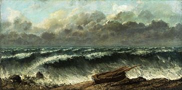
A version by La vague , Courbet, Étretat en 1869–1870, musée André-Malraux, Le Havre

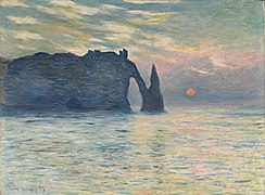
Claude Monet , Étretat , 1883

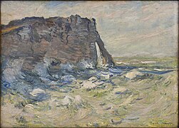
Claude Monet, Étretat, la plage et la porte d'Amont , 1883

Claude Monet, Étretat, l'aiguille et la falaise , 1885

Claude Monet, la porte d'aval avec des bateaux partant à la pêche , 1885


Claude Monet, Pluie à Étretat , 1884
Claude Monet, La falaise d'Étretat, soleil couchant , 1883, 55.2 × 80.6 cm., North Carolina Museum of Art

Claude Monet, Tempête à Étretat , 1868
Claude Monet, Marée Haute , 1885

Claude Monet, Bateaux sur la plage à Étretat , 1885, Fondation Bemberg, Toulouse

Claude Monet, La manneporte à Étretat , 1886


Étretat has been a subject in painting since the beginning of the Romantic period . The list of painters who have dealt with it is long; they include:
- Richard Parkes Bonington - watercolors, 1823
- Eugène Boudin - painting, 1864
- Jean-Baptiste Camille Corot - painting, 1872
- Gustave Courbet - painting, the rocks and the waves during his stay in 1869
- Eugène Delacroix - Watercolors
- Narcisso Virgilio Díaz de la Peña - paintings
- Paul Huet - watercolors
- Eugène Isabey - watercolors, from 1824 he often painted the cliffs between Le Havre and Dieppe
- Johan Barthold Jongkind - painting, 1850–1853
- Eugène Lepoittevin - Painting of a dive into the sea entitled Les bains de mer
- Henri Matisse - series of paintings during his stay from June to August 1920
- Claude Monet - series of more than 80 paintings during his stays in 1868, 1869, 1872, 1882, 1891 and 1916.
literature
- Pierre Auger, Gérard Granier: Le guide du Pays de Caux . Editions la Manufacture 1993.
- Abbé Cochet : Petite histoire d'Étretat . Éditions PyréMonde, 2006.
- Françoise Foucher: Étretat , Éditions d'Art Jack, Louannec, June 2018, ISBN 978-2-37773-037-7 , page 15.
- Jean-Pierre Thomas: Un village né de la mer Étretat . Orep, 2010.
Web links
Remarks
- ↑ Nordic Names (English)
- ^ German Society of Seaside Resorts of Étretat
- ↑ What is meant is not granite in the geological sense, but hard, granular rock in the broader sense. The rock is not made of granite.
- ↑ French empierré
- ↑ German manhole
- ↑ German small port
Individual evidence
- ↑ Pierre Auger, Gérard Granier: Le guide du Pays de Caux , Editions la Manufacture 1993. pp. 76-77.
- ↑ Pierre Auger, Gérard Granier: Le guide du Pays de Caux , p. 79.
- ^ Françoise Foucher, Étretat , Éditions d'Art Jack, Louannec, June 2018, ISBN 978-2-37773-037-7 , page 4
- ^ Raymond Lindon: Étretat, son histoire, ses légends , les Éditions de Minuit 1963.
- ↑ Abbé Cochet: Petite histoire d'Étretat , Éditions PyréMonde, 2006, original publisher 1845.
- ^ François de Beaurepaire: Les Noms des communes et anciennes paroisses de la Seine-Maritime . Ed .: A. and J. Picard. Center national de la recherche scientifique , Paris 1979, ISBN 2-7084-0040-1 .
- ^ François de Beaurepaire: Les noms des communes et anciennes paroisses de l'Eure , éditions Picard 1981, ISBN 2-7084-0067-3
- ^ Elisabeth Ridel: Bateaux de type scandinave en Normandie (Xe siècle - XIIIe siècle) , p. 311. In: Colloque international de la Hague, L'héritage des Vikings en Europe de l'ouest , Université de Caen 2002.
- ↑ a b DE BEAUREPAIRE 75
- ↑ a b c Legends (Étretat)
- ↑ shipment Les États d'Etretat , interview by Benoît Duteurtre , broadcast in 1991
- ↑ The community on cassini.ehess.fr
- ^ Georges Bernage : Patrimoine normand 53 (2005). Pp. 29-37
- ↑ Séjourner aux Aygues (chateaulesaygues.com)