
La Cerlangue
| La Cerlangue | ||
|---|---|---|
|
||
| region | Normandy | |
| Department | Seine-Maritime | |
| Arrondissement | Le Havre | |
| Canton | Saint-Romain-de-Colbosc | |
| Community association | Caux Estuaire | |
| Coordinates | 49 ° 30 ' N , 0 ° 25' E | |
| height | 0-127 m | |
| surface | 27.93 km 2 | |
| Residents | 1,289 (January 1, 2017) | |
| Population density | 46 inhabitants / km 2 | |
| Post Code | 76430 | |
| INSEE code | 76169 | |
| Website | http://www.lacerlangue.fr/ | |

La Cerlangue is a French commune with 1,289 inhabitants (as of January 1 2017) in the department of Seine-Maritime in the region Normandy . It belongs to the arrondissement of Le Havre and is part of the canton of Saint-Romain-de-Colbosc .
geography
La Cerlangue is located about 22 kilometers east of Le Havre in the historic province of Pays de Caux . La Cerlangue is surrounded by the neighboring communities of La Remuée in the north, Mélamare in the northeast, Saint-Nicolas-de-la-Taille in the east, Tancarville in the east and southeast, Marais-Vernier in the southeast, and Saint-Samson-de-la-Roque in the South, Saint-Vigor-d'Ymonville to the west and Saint-Vincent-Cramesnil to the west and northwest.
The A131 autoroute runs through the municipality .
Population development
| year | 1962 | 1968 | 1975 | 1982 | 1990 | 1999 | 2006 | 2013 |
|---|---|---|---|---|---|---|---|---|
| Residents | 740 | 754 | 890 | 895 | 983 | 1.106 | 1,190 | 1,307 |
Attractions
- Saint-Léonard church from the 13th century, monument historique
- 11th century church of Saint-Jean-d'Abbetot
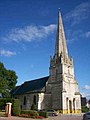
Saint-Léonard church

Saint-Jean-d'Abbetot church
_23-09-2007_001_redimensionn%C3%A9e_pour_Wikip%C3%A9dia.jpg)
