
La Poterie-Cap-d'Antifer
| La Poterie-Cap-d'Antifer | ||
|---|---|---|
|
||
| region | Normandy | |
| Department | Seine-Maritime | |
| Arrondissement | Le Havre | |
| Canton | Octeville-sur-Mer | |
| Community association | Canton de Criquetot-l'Esneval | |
| Coordinates | 49 ° 40 ′ N , 0 ° 11 ′ E | |
| height | 0-114 m | |
| surface | 5.81 km 2 | |
| Residents | 453 (January 1, 2017) | |
| Population density | 78 inhabitants / km 2 | |
| Post Code | 76280 | |
| INSEE code | 76508 | |
.jpg) Town hall (Mairie) of La Poterie-Cap-d'Antifer |
||

La Poterie-Cap-d'Antifer is a French municipality with 453 inhabitants (as of January 1 2017) in the department of Seine-Maritime in the region Normandy . It belongs to the arrondissement of Le Havre and the canton of Octeville-sur-Mer (until 2015: canton of Criquetot-l'Esneval ).
geography
La Poterie-Cap-d'Antifer is located about 20 kilometers north-northeast of Le Havre on the English Channel . La Poterie-Cap-d'Antifer is surrounded by the neighboring communities of Le Tilleul in the north and east, Sainte-Marie-au-Bosc in the southeast and Saint-Jouin-Bruneval in the south. The village of La Place also belongs to the municipality . The coast belonging to the municipality is part of the Alabaster Coast and includes striking points such as the eponymous Cape d'Antifer and Pointe du Fourquet , as well as beaches such as the Plage du Tilleul .
history
During Operation Biting (also: Bruneval Raid ) the Royal Air Force tried on 27./28. February 1942 successfully dismantling the Würzburg radar in Bruneval. The operation was carried out via Cape Antifer.
Population development
| year | 1962 | 1968 | 1975 | 1982 | 1990 | 1999 | 2006 | 2013 |
| Residents | 297 | 269 | 273 | 314 | 304 | 316 | 361 | 445 |
| Source: Cassini and INSEE | ||||||||
Attractions
- Saint-Martin church from the 17th century
- Antifer lighthouse
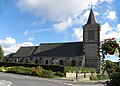
Saint Martin Church

lighthouse

