
Saint-Maurice-d'Ételan
| Saint-Maurice-d'Ételan | ||
|---|---|---|
|
||
| region | Normandy | |
| Department | Seine-Maritime | |
| Arrondissement | Le Havre | |
| Canton | Notre-Dame-de-Gravenchon | |
| Community association | Caux Seine agglo | |
| Coordinates | 49 ° 28 ' N , 0 ° 37' E | |
| height | 3–121 m | |
| surface | 14.24 km 2 | |
| Residents | 305 (January 1, 2017) | |
| Population density | 21 inhabitants / km 2 | |
| Post Code | 76330 | |
| INSEE code | 76622 | |

Saint-Maurice-d'Ételan is a French municipality with 305 inhabitants (as of January 1 2017) in the department of Seine-Maritime in the region Normandy . It belongs to the arrondissement of Le Havre and the canton of Notre-Dame-de-Gravenchon (until 2015: canton of Lillebonne ). The inhabitants are called Saint-Mauriçais .
geography
Saint-Maurice-d'Ételan is located about 37 kilometers east of Le Havre in the Pays de Caux on the Seine . Saint-Maurice-d'Ételan is surrounded by the neighboring communities of Triquerville in the north, Norville in the north and north-east, Vatteville-la-Rue in the east, Aizier in the south, Petiville in the west and Notre-Dame-de-Gravenchon in the north-west.
Population development
| 1962 | 1968 | 1975 | 1982 | 1990 | 1999 | 2006 | 2013 |
|---|---|---|---|---|---|---|---|
| 241 | 255 | 243 | 230 | 211 | 239 | 326 | 313 |
| Source: Cassini and INSEE | |||||||
Attractions
- Saint-Maurice church, built at the end of the 15th century
- Ételan Castle from 15th / 16th centuries Century, Monument historique
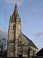
Saint-Maurice Church

Ételan Castle


Personalities
- André Bettencourt (1919–2007), journalist and politician, French Minister for Industry and Foreign Affairs
- Pierre Bettencourt (1917–2006), painter and writer
Web links
Commons : Saint-Maurice-d'Ételan - Collection of images, videos and audio files