
Grainville-Ymauville
| Grainville-Ymauville | ||
|---|---|---|

|
|
|
| region | Normandy | |
| Department | Seine-Maritime | |
| Arrondissement | Le Havre | |
| Canton | Saint-Romain-de-Colbosc | |
| Community association | Campagne-de-Caux | |
| Coordinates | 49 ° 39 ′ N , 0 ° 25 ′ E | |
| height | 93-135 m | |
| surface | 6.29 km 2 | |
| Residents | 439 (January 1, 2017) | |
| Population density | 70 inhabitants / km 2 | |
| Post Code | 76110 | |
| INSEE code | 76317 | |
 Town Hall (Mairie) of Grainville-Ymauville |
||

Grainville-Ymauville is a French municipality with 439 inhabitants (as of January 1 2017) in the department of Seine-Maritime in the region Normandy . It belongs to the arrondissement of Le Havre and the canton of Saint-Romain-de-Colbosc (until 2015: canton of Goderville ).
geography
Grainville-Ymauville is located about 23 kilometers northeast of Le Havre in the Pays de Caux . Grainville-Ymauville is surrounded by the neighboring communities of Gonfreville-Caillot in the north, Saint-Maclou-la-Brière in the northeast, Bernières in the east, Nointot in the south, Mirville in the southwest and Bréauté in the west.
Population development
| year | 1962 | 1968 | 1975 | 1982 | 1990 | 1999 | 2006 | 2013 |
| Residents | 287 | 255 | 232 | 317 | 334 | 392 | 401 | 429 |
| Source: Cassini and INSEE | ||||||||
Attractions
- Saint-Vigor-et-Notre-Dame church from the 18th century
- Trébons Castle, rebuilt in 1767, Monument historique
- White Castle, built between 1854 and 1859
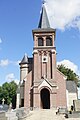
Saint-Vigor-et-Notre-Dame church

Trébons Castle


Personalities
- Jacques Allard (1903–1995), infantry general
- Nicole Fontaine (1942–2018), politician, former Vice-President of the European Parliament
Web links
Commons : Grainville-Ymauville - Collection of Images, Videos, and Audio Files