Valkenswaard
 flag |
 coat of arms |
| province |
|
| mayor | Anton Ederveen ( CDA ) |
| Seat of the municipality | Valkenswaard |
|
Area - land - water |
56.44 km 2 54.97 km 2 1.47 km 2 |
| CBS code | 0858 |
| Residents | 30,928 (Jan 31, 2019) |
| Population density | 548 inhabitants / km 2 |
| Coordinates | 51 ° 21 ′ N , 5 ° 28 ′ E |
| Important traffic route |
|
| prefix | 040 |
| Postcodes | 5550-5556 |
| Website | Homepage of Valkenswaard |
Valkenswaard ( ) is a municipality in the Netherlands , province of Noord-Brabant . The total area of the municipality is 56.44 km². Valkenswaard has 30,928 inhabitants (as of January 31, 2019).
places
- Valkenswaard, where the municipal administration is located
- Dommelen, which is growing rapidly with new buildings
- Borkel shaft
Location and economy
Valkenswaard is between Eindhoven and in Belgium lying Lommel . The road between these cities has not been converted into a motorway because it runs through natural areas outside the village. A new ring road leads around the center, through the outskirts of Valkenswaard.
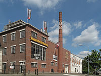
Valkenswaard has a beer brewery (Dommelsch), a cigar factory and some small businesses; tourists also come here because of the beautiful, wooded surroundings and the many cafes and discos. A few kilometers south of Westerhoven is the Center Parc de Kempervennen .
The majority of the population are commuters who work in Eindhoven or Hasselt (Belgium) , among others . The Philips group has plants in both cities .
history
In the Middle Ages , the poor farming village Wedert (or Verkenswedert , because the local farmers lived from pig breeding ; Dutch varken = Brab, dialect verken = pig) was established here. In the 17th century the village became a center for falconers , who were able to catch many of these birds of prey here. A statue in the center of Valkenswaard still reminds of this. Between around 1850 and 1940 the place had a thriving cigar industry . On September 17, 1944 , this was largely destroyed during acts of war. Only the two largest companies (“Hofnar” and “Willem II”) were able to prove themselves for a few decades after the end of the war. Due to the influx of other small industries, the village grew strongly, also because employees of the Philips works had their new apartments built here.
Attractions
- Church of St. Nicholas ( Rijksmonument )
- The nature reserve "De Malpie", with forest, heather, the streams Tongelreep and Dommel and small ponds or lakes (Dutch vennen ).
- The VSMM (Hawk Hunting and Cigar Making Museum).
- The Museum of Lithography (Steendrukmuseum).
- The Van Gerwen Lemmens Museum (ecclesiastical art).
- The flower parade , every year on the second Sunday in September.
- The lively carnival when the village is called “Striepersgat”.
- The center has numerous bars, cafes, discos and other entertainment venues.
- There are several hotels, campsites and swimming pools in the municipality.
Sports
Valkenswaard has been one of the stations of the Global Champions Tour since 2006 and thus attracts the best riders in the world to Valkenswaard every year. The place has hosted the Motocross World Championship for years .
The Valkenswaardse RC is the only foreign representative to be included in the German roller hockey Bundesliga .
Town twinning
-
 Tienen , Belgium
-
 Salvaterra de Magos , Portugal (40 km northeast of Lisbon )
Born in the church
- Adriaan Smets (1867–1947), Catholic archbishop and diplomat
- Joseph Jacobus van den Besselaar (1916–1991), classical philologist, Romanist and Lusitanist , taught temporarily in Brazil
- Bouke Beumer (* 1934), politician
- Karel Adriaan Deurloo (1936–2019), Reformed pastor, professor of theology and author
- Georges Christoffel Maria Evers (1950–2003), nursing scientist
- Linda Williams (* 1955), pop singer
- Jan Tops (* 1961), former show jumper and horse dealer
- Frank Roberscheuten (* 1962), jazz musician
- Dominique van Hulst (* 1981), pop singer
Web links
- Website of the municipality (Dutch)
- Website of the De Groote Heide tourist office (Dutch)
- Website of the Lithography Museum (German, Dutch, English)
- Falconry and Cigar Making Museum website (Dutch, German, English)
Individual evidence
- ↑ Bevolkingsontwikkeling; regio per maand . In: StatLine . Centraal Bureau voor de Statistiek (Dutch)


