
Žlutice
| Žlutice | |||||
|---|---|---|---|---|---|
|
|||||
| Basic data | |||||
| State : |
|
||||
| Region : | Karlovarský kraj | ||||
| District : | Karlovy Vary | ||||
| Area : | 5303,309 ha | ||||
| Geographic location : | 50 ° 5 ' N , 13 ° 10' E | ||||
| Height: | 497 m nm | ||||
| Residents : | 2,305 (Jan 1, 2019) | ||||
| Postal code : | 364 52 | ||||
| License plate : | K | ||||
| traffic | |||||
| Street: | Bochov - Manětín | ||||
| Railway connection: | Rakovník - Bečov nad Teplou | ||||
| Next international airport : | Karlovy Vary Airport | ||||
| structure | |||||
| Status: | city | ||||
| Districts: | 9 | ||||
| administration | |||||
| Mayor : | Václav Slavík (as of 2012) | ||||
| Address: | Velké náměstí 144 364 52 Žlutice |
||||
| Municipality number: | 555762 | ||||
| Website : | www.zlutice.cz | ||||
| Location of Žlutice in the Karlovy Vary district | |||||

|
|||||


Žlutice (German Luditz ) is a small town in Karlovarský kraj in the Czech Republic .
geography

The city is located in western Bohemia on a southeast slope south of the Duppov Mountains ( Doupovské Hory ) and northeast of the Tepler Highlands ( Tepelská vrchovina ), at an altitude of about 450 m above sea level. The Střela ( Schnella ) flows through the southern part of the city . To the west of the city is the Žlutice drinking water reservoir .
National road 6 runs five kilometers north of Žlutice from Eger via Karlsbad to Prague ; the distance (as the crow flies) to Karlovy Vary is 25 km to the northwest. The mountain Nevděk rises to the south of the city and the Vladař to the southeast .
history


The Czech city name "Žlutice" probably comes from the name of the ancestor of a family called "Žlutici". The first historical news about Luditz comes from the year 1140, when knight Zdimir donated the village "Zlutic" to the monastery Kladruby . Between 1306 and 1341 it became a town with Egerer law.
As early as the 13th century (1214: "civitatem Ludicz") the city name was written in the German form without the initial Z. The German spelling Luticz can also be found throughout the confirmation books of the Prague diocese from 1356 to 1435. In the time of the old Bohemian great districts, Luditz belonged to the Saaz district from around 1350 to 1751 , and from 1751 to 1850 to the Elbogen district .
The first news from a school in Luditz comes from August 16, 1371, when the "cleric Benda, rector of the schools in Luticz" was appointed pastor of Stiedra. According to the construction books, the parish church had had its own priest since 1375. During the Hussite Wars, the city was stormed by the Taborites in 1422 and largely destroyed. In the 16th century, the textile industry in particular flourished. In 1542 Heinrich IV. Von Plauen , Burgrave of Meißen and Colonel Chancellor of Bohemia, pledged the Luditz rule to Count Lorenz Schlick for five years . He promoted the Reformation and brought the Lutheran theologian Johannes Criginger from Wittenberg as court preacher .
In 1575 Georg Adam Kokorowetz Ritter von Kolorowa bought the rule for 33,000 shock groschen. In 1637 Peter Georg Kokorowetz von Kolorowa was raised to the baron status and in 1680 Ferdinand Hroznata Kokorowetz von Kolorowa was raised to the rank of count. The latter appointed with effect from 22 July 1698 the rule Luditz including Thöni's in favor of his eldest son Peter Franz to primogeniture , while the other half of his possessions fell to his other children as Allodium. Luditz remained in the family's possession until 1878. A Trinity column has adorned the Ringplatz since 1712.
1847 counted the protection and municipal towns with the upper and lower suburbs 271 houses with 1758 inhabitants. It was surrounded by a wall and 2 gates, the so-called Chiescher and Theusinger gate. Luditz had his own (Catholic) rectory, the parish church of St. Peter and Paul and a cemetery church for the Holy Trinity. Luditz was also the seat of a Catholic deanery. After the patrimonial jurisdiction was abolished, the Luditz judicial district was formed. After the administrative reform in 1850, Luditz belonged to the Political District of Luditz and its judicial district of Luditz until 1938 .
Until the end of the First World War in 1918 the place belonged to the crown land of Bohemia of the Austro-Hungarian monarchy. After the proclamation of Czechoslovakia on October 28, 1918, Luditz was also occupied by Czech troops. The invasion of units of the 35th Infantry Regiment from Pilsen took place here on December 6, 1918, the German People's Army offered no resistance. In 1919, Luditz was officially added to the newly created Czechoslovakia by the victorious powers .
At the 1930 census, Luditz had residents in 2019, only 139 of whom were Czech. Due to the Munich Agreement , Luditz came to the German Reich in 1938 and until 1945 belonged to the Luditz district , Eger district , in the Reichsgau Sudetenland . On May 8, 1945, the last day of World War II , soldiers from the US 97th Infantry Division entered the city. The US troops met Red Army soldiers near the town .
After the war, the German-speaking population was from Luditz expelled , their property, citing the Benes Decree 108 confiscated and the Catholic Church expropriated . The Žlutice dam was built between 1965 and 1968, when the villages Dolánky, Mlyňany and Skoky were abandoned. In 1996, in cooperation between the city administration of Žlutice and the expellees from the city and the Luditz district, the war memorial from 1929 for the fallen of World War I was secured with a retaining wall. In the course of this work, a memorial and warning plaque was attached to the retaining wall , which is dedicated to all victims of war, violence and displacement .
In 1938 the city was named after the Munich agreement the German Reich slammed and was until 1945 the county seat of the same district Luditz in the Reich District of Sudetenland , Region of Eger . After the end of the Second World War, Žlutice became part of the Czechoslovak Republic again. Until 1949, the old district division was initially applied again, then Žlutice lost its status as a district town and was assigned to the Okres Toužim . Since its dissolution on January 1, 1961, Žlutice has belonged to the Okres Karlovy Vary.
Demographics
Until 1945 Luditz was mostly populated by German Bohemia , which were expelled.
| year | Residents | Remarks |
|---|---|---|
| 1785 | k. A. | 228 houses including the suburb |
| 1830 | 1395 | in 242 houses |
| 1847 | 1758 | in 271 houses |
| 1900 | 1847 | German residents |
| 1921 | 2008 | 1916 of them Germans |
| 1930 | 2019 | including 139 Czechs |
| 1939 | 1970 |
| year | 1970 | 1980 | 1991 | 2001 | 2003 |
|---|---|---|---|---|---|
| Residents | 2195 | 2532 | 2802 | 2869 | 2817 |
City structure
The town of Žlutice consists of the districts Knínice ( Knönitz ), Protivec ( Protowitz ), Ratiboř ( Ratiworz ), Skoky ( Mariastock ), Verušice ( Groß Werscheditz ), Veselov ( Paßnau ), Vladořice ( Wladar ), Záhořice ( Sahor ) and Žlutice Luditz ). Basic settlement units are Hradský Dvůr ( Ratzkahof ), Knínice, Mlyňany ( Lindles ), Protivec, Ratiboř, Skoky, Verušice, Veselov, Vladořice, Záhořice and Zlutice. The Dolánky ( Dollanka ) desert also belongs to Zlutuce .
The municipality is divided into the cadastral districts of Knínice u Žlutic, Mlyňany, Protivec u Žlutic, Ratiboř u Žlutic, Skoky u Žlutic, Verušice, Veselov, Vladořice, Záhořice and Zlutice.
Attractions
- City Palace
- Church of St. Peter and Paul
- Trinity Column
- city Museum
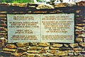
Bilingual plaque
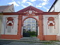
Gate of the city palace

Holy Trinity Column in the market


sons and daughters of the town
- Johann Sobeck (1831–1914), composer and clarinetist
- Emanuel Wirth (1842–1923), violinist
- Hugo Liehm (1879–1958), clarinet manufacturer, politician (DNP, SdP, NSDAP) and mayor of Luditz 1926–1935
- German Joseph Krieglsteiner (1937–2001), mycologist
literature
- Karl Fleissner: The history of the city of Luditz in chronological representation. K. Fleißner, Luditz 1936. (2nd edition Bronner and Daentler, Eichstätt 1994. DNB 941,625,745 ; in Czech: . Dějiny města Žlutic v chronologickém podání . Přeložil Roman Jírů Muzejní spolek Žlutická, Žlutice 2012, ISBN 978-80-260 -2660-0 )
- Jan Šícha, Eva Habel, Peter Liebald, Gudrun Heissig: Odsun. The expulsion of the Sudeten Germans. Sudeten German Archive, Munich 1995, ISBN 3-930626-08-X .
Web links
Individual evidence
- ↑ uir.cz
- ↑ Český statistický úřad - The population of the Czech municipalities as of January 1, 2019 (PDF; 7.4 MiB)
- ^ Yearbook of the Society for the History of Protestantism in Austria . J. Klinkhardt, 1909 ( google.de [accessed April 18, 2020]).
- ↑ Johann Gottfried Sommer: The Kingdom of Bohemia: bd. Elbogner Kreis. 1847 . JG Calve, 1847 ( google.de [accessed April 18, 2020]).
- ^ German genealogy: Sudetenland, Parish Books, Luditz. Retrieved April 18, 2020 .
- ^ Rudolf Hemmerle : Sudetenland Lexicon. (= German landscapes in the lexicon. 4). 2nd, expanded edition. Adam Kraft, Mannheim 1985, ISBN 3-8083-1163-0 , p. 276.
- ↑ Chronicle of the US 97th Infantry Division
- ↑ Jaroslaus Schaller : Topography of the Kingdom of Bohemia . Volume 2: Ellbogner Kreis , Prague 1785, pp. 136-138, item 1) .
- ↑ Yearbooks of the Bohemian Museum of Natural and Regional Studies, History, Art and Literature . Volume 2, Prague 1831, p. 200, paragraph 21.
- ↑ Johann Gottfried Sommer : The Kingdom of Bohemia . Volume 15: Elbogner Kreis , Prague 1847, p. 201, item 1.
- ^ Meyer's Large Conversational Lexicon . 6th edition, Volume 12, Leipzig and Vienna 1908, p. 772 .
- ^ Sudetenland Genealogy Network
- ^ A b Michael Rademacher: German administrative history from the unification of the empire in 1871 to the reunification in 1990. Luditz district. (Online material for the dissertation, Osnabrück 2006).
- ↑ Czech population statistics
- ↑ uir.cz
- ↑ uir.cz
- ↑ uir.cz