
Kota Kinabalu: Difference between revisions
m robot Modifying: zh:亞庇 |
Removing image with no source information. Such images that are older than seven days may be deleted at any time. |
||
| Line 133: | Line 133: | ||
=== Land=== |
=== Land=== |
||
[[Image:DSC01024.JPG|right|thumb|300px|{{speedy-image-c|[[2007-05-13]]}} Aerial photo of northern Kota Kinabalu, and Jalan Tun Fuad Stephens (Likas coastal highway) along Likas Bay]] |
<!-- Unsourced image removed: [[Image:DSC01024.JPG|right|thumb|300px|{{speedy-image-c|[[2007-05-13]]}} Aerial photo of northern Kota Kinabalu, and Jalan Tun Fuad Stephens (Likas coastal highway) along Likas Bay]] --> |
||
The internal [[road]]s linking different parts of the city are generally [[Malaysian State Roads system|state roads]] constructed and maintained by the state [[Malaysian Public Works Department|Public Works Department]]. Most major internal roads are [[dual-carriageways]]. One of the major road here is Jalan Lintas-Jalan Tuaran Bypass, which together serves almost as a [[ring road]], circling the city and connecting the districts and suburbs surrounding the city, namely, Putatan, Penampang, Luyang, Likas, Inanam, Menggatal, Sepanggar, and Tuaran. There is currently no [[freeway]] in the city nor in any part of Sabah. The city is linked by [[highway]]s to distant towns around Sabah and these are mainly [[Malaysian Federal Roads system|federal roads]] maintained by the national Public Works Department. Highway routes from Kota Kinabalu include: |
The internal [[road]]s linking different parts of the city are generally [[Malaysian State Roads system|state roads]] constructed and maintained by the state [[Malaysian Public Works Department|Public Works Department]]. Most major internal roads are [[dual-carriageways]]. One of the major road here is Jalan Lintas-Jalan Tuaran Bypass, which together serves almost as a [[ring road]], circling the city and connecting the districts and suburbs surrounding the city, namely, Putatan, Penampang, Luyang, Likas, Inanam, Menggatal, Sepanggar, and Tuaran. There is currently no [[freeway]] in the city nor in any part of Sabah. The city is linked by [[highway]]s to distant towns around Sabah and these are mainly [[Malaysian Federal Roads system|federal roads]] maintained by the national Public Works Department. Highway routes from Kota Kinabalu include: |
||
*Kota Kinabalu - Tamparuli - Kudat |
*Kota Kinabalu - Tamparuli - Kudat |
||
Revision as of 06:45, 12 May 2007
Kota Kinabalu | |
|---|---|
 | |
| Nickname: 'KK' | |
 Location in Malaysia | |
| Country | Malaysia |
| State | Sabah |
| Settled by BNBC | 1882 |
| Declared capital of North Borneo | 1946 |
| Granted city status | February 2, 2000 |
| Government | |
| • Mayor | Datuk Illiyas Ibrahim |
| Population (2007) | |
| • City | 532 129 [1] |
| • Urban | 700,000 |
| • Metro | 900,000 |
| Time zone | UTC+8 (MST) |
| Postcode | 88xxx; 89xxx |
| Area code | 088 |
| Website | http://www.dbkk.sabah.gov.my |
Kota Kinabalu, formerly known as Jesselton, is the capital of the Malaysian state of Sabah, as well as the capital of the West Coast Division of Sabah. Located on the north-west coast of the island of Borneo facing South China Sea and Tunku Abdul Rahman Park on one side, and with Mount Kinabalu in the background, Kota Kinabalu sprawls for kilometers along the coast and towards inland. With an estimated population of 532 129 in the city and 700,000 in the urban area, it is the largest urban centre in Sabah and the sixth largest in Malaysia.[1]
Kota Kinabalu, often simply known as K.K., is well known within Malaysia, and to an extent, internationally, as a tourism getaway and a major gateway into Sabah and Borneo. Kinabalu National Park, a World Heritage Site, is located about 90 kilometres from the city, and besides this, it also features a number of tourist attractions in and around the city itself. The city is also one of the major industrial and commercial centers in East Malaysia besides Kuching in Sarawak. These two factors combine to make Kota Kinabalu one of the fastest growing cities in the country.[2]
History
During the late 1800s, the British North Borneo Company (BNBC) became interested in establishing colonies throughout North Borneo (now Sabah). In 1882, the Company created a small settlement on Gaya Island (Pulau Gaya), which was already inhabited by a people known as the Bajaus. This first settlement was torched and destroyed by the Bajau rebel Mat Salleh in 1897.[3]
After the effacement, the Company decided to relocate the settlement to the more easily defended mainland opposite Pulau Gaya. A nearby fishing village named Api-Api (see Original names below), was the next settlement of the Company. This new location is then made to be the main harbour and port, as well as the terminus for the North Borneo Railway. It was expanded and renamed Jesselton, after the name of the then Vice Chairman of the Company, Sir Charles Jessel.
Eventually, Jesselton became a major trading post of North Borneo, dealing in rubber, rattan, honey, and wax. The new railway was used to transport goods to the Jesselton harbour. Bajau uprisings during these times were not uncommon, and the Company worked to quell the long-standing threat of piracy in the region.

Jesselton was razed by the retreating British early in World War II to prevent it from falling into the hands of the Japanese. After the Japanese takeover of Borneo, it was again renamed Api. Rebellions against the Japanese military administration have taken place in Api. One major rebellion occurred in 1943 by the group called Kinabalu Guerrillas, consisting of local inhabitants. The rebellion was however quelled by the Japanese forces, after their leader, Albert Kwok, was arrested and executed in 1944.[4] At the later stages of the war, what remained of the town was destroyed again by Allied bombings as part of the Borneo Campaign in 1945, leaving only three buildings standing. The war in North Borneo ended with the official surrender of the Japanese 37th Army by Lieutenant General Baba Masao in Labuan on September 10, 1945.
After the war, the British North Borneo Company returned to administer Jesselton but were unable to finance the huge costs of reconstruction. They gave control of North Borneo to the British crown in 1946. The new colonial government elected to rebuild Jesselton as the capital of North Borneo instead of Sandakan, which had also been destroyed by the war.[5]
When North Borneo joined the Federation of Malaysia in 1963, the state became known as Sabah and Jesselton remained its capital. Jesselton was renamed Kota Kinabalu on September 30, 1968 and received official city status from the Malaysian government on February 2, 2000.

Etymology
Kota Kinabalu is named after Mount Kinabalu, situated about 90 kilometres east-northeast of the city. The meaning and origin of the name Kinabalu is uncertain. One theory suggests it means "Chinese widow", where Kina meaning "Chinese" (person) in Kadazandusun language, and balu meaning "widow" in Malay language. This theory derives from a folk tale about a Chinese prince who came to the mountain in search of a giant pearl which is guarded by a dragon at the top of the mountain. While he was here, he married a local woman but later returned to China and left the woman heartbroken.[6] Alternatively, it is also argued that Kinabalu or Akinabalu is the name of the dragon which guards the giant pearl itself.[7][8] Another theory suggests that the term is derived from the name Aki Nabalu meaning the "revered place of the dead", in which, Aki means "ancestors" or "grandfather", and Nabalu being a name for the mountain in the Dusun language.[9] Finally there is also a source claiming that the term originated from Ki Nabalu, where Ki meaning "have" or "exist", and Nabalu meaning "spirit of the dead".[6]
Kota is a Malay word for a "fort", "town", or a "city". It is also used formally in a few other Malaysian towns and cities, for example, Kota Bahru, Kota Tinggi, and Kota Kemuning. It could also be used informally to refer to any towns or cities. Henceforth, a direct translation of the name Kota Kinabalu into English would be "City of Kinabalu" or "Kinabalu City".
Original names
Besides Jesselton, there has been a number of other claims as to the original name for Kota Kinabalu. The most popular, as mentioned above, is Api-Api, or sometimes simply Api, which is a Malay word meaning 'Fire'. It was apparently named as such by the mainly Bajau locals to denote the blazing of the British administrative office in Pulau Gaya instigated by Mat Salleh,[10] as well as other blazing incidents normally perpetrated by pirates. There were claims however that it was actually named after a nearby river called Sungai Api-Api. Another theory states that "Api-Api" is the local name of the common Avicennia tree found in abundance around the area.[11] Transliterated into the formal Chinese name of Ya Bi (亚庇 yà bì), the Hakkas here too adopted this name and some still use this name until today.[12] Besides Api-Api, another suggested historical name was Deasoka, which roughly means "below the coconut tree" in the Bajau language.[11] The Bajau locals purportedly used this name to refer to a village on the southern part of the city which was filled with coconut trees. Another name was Singgah Mata which literally mean "transit eye", but can be loosely translated as meaning "pleasing to the eye". It is a name purportedly given by fishermen from Pulau Gaya referring to the strip of land of what is today Kota Kinabalu city center.[13] Today, all these names have been immortalised into names of streets or buildings around the city. Some examples are: Lintasan Deasoka, Api-Api Centre, Jalan Singgah Mata, and Jesselton Point.
Capital city


Being the capital city of Sabah, Kota Kinabalu plays an important role in the political and economic welfare of the population in the entire state. It is the seat of the state government where almost all of their ministries and agencies are based. Most of the Malaysian federal government agencies and departments are also located in Kota Kinabalu. It is also the seat for the Sabah State Legislative Assembly which is located in near Likas Bay. There are four Members of Parliament (MPs) representing four parliamentary constituency for the city: Sepanggar (P.171), Kota Kinabalu (P.172), Putatan (P.173), and Penampang (P.174). The city also elects 9 representatives to the state legislature from the state assembly districts of Karambunai, Inanam, Likas, Api-Api, Luyang, Tanjung Aru, Petagas, Kepayan, and Moyog.[14]
Local authority and city definition
The city is administered by Dewan Bandaraya Kota Kinabalu (Kota Kinabalu City Council). The current mayor of Kota Kinabalu is Datuk Illiyas Ibrahim. He became the second mayor of the city after taking over the post from Datuk Abdul Ghani Rashid in 2006. The city obtained city status on February 2, 2000, and prior to this it was administered by Majlis Perbandaran Kota Kinabalu (Kota Kinabalu Municipal Council).
The city is defined within the borders of what is the district, and formerly, the municipality, of Kota Kinabalu. With a total area of 351 square kilometres, it is the smallest but the most populous district in Sabah.[15] It encompasses Tanjung Aru and Kepayan in the south, up to Telipok and Sepanggar in the north. The urban expanse of the city however extends into the district of Penampang[16] on the south of the city border, which includes the towns of Donggongon and Putatan. The combined area of Kota Kinabalu (district) and Penampang can also be described as Kota Kinabalu (urban area). The district of Penampang has a total area of 466 square kilometres, and is administered by Majlis Daerah Penampang (Penampang District Council).[17]
On one end of the scale, Kota Kinabalu may sometimes only refer to, especially by local inhabitants, the city centre or central business district, area near the sea facing Pulau Gaya. On the other end of the scale, it may also refer to the metropolitan area which includes urban Kota Kinabalu, and the surrounding towns of Papar and Kinarut, in the south, and Tuaran and Tamparuli, in the north, being within its zone of influence.
Sister Cities
Kota Kinabalu currently has two sister cities.[18]
Geography
Kota Kinabalu is located on the west coast of Sabah. The city lies on a narrow flatland, being enveloped by Crocker Range from the east, and by South China Sea from the west. The city itself contains several hills which are mostly covered with tropical rainforest. The flat areas are mostly built up commercial or residential areas. The northeast part of the city around Likas Bay used to contain an extensive mangrove forest, but most of it has disappeared leaving only a 24-acre sanctuary recently designated as Kota Kinabalu City Bird Sanctuary in 2000. The central business district (CBD) is located on a narrow strip of land bordered by Signal Hill and the sea. Because of want in land in the area, most of the CBD today is built on reclaimed land. There is also a height limit imposed on buildings in the CBD because of the proximity with the airport being just 7 kilometres away, and further lying directly in the path of aircraft landing and taking-off.

The areas within the city centre includes Karamunsing, the port area (Tanjung Lipat), Signal Hill, Kampung Air, Sinsuran, Segama, Asia City, Gaya Street (Old Town), Bandaran Berjaya, Api-Api, Sutera Harbour, and Sembulan. Outlying neighbourhoods or suburbs includes Kepayan Ridge, Tanjung Aru, Petagas, Kepayan, Lido, Lintas, Nosoob, Bukit Padang, Luyang, Damai, Likas, and Kolombong. Rapid economic development in the city has resulted in an urban sprawl connecting surrounding towns and sub-districts including Inanam, Menggatal, Sepanggar, Telipok, Donggongon, Putatan, and Lok Kawi.
There are six islands located off the coast of the city. Five of which, designated under the Tunku Abdul Rahman National Park, are Pulau Gaya, Pulau Sapi, Pulau Manukan, Pulau Sulug, and Pulau Mamutik. These islands are popular among tourists visiting the city as well as for locals. The islands are mainly uninhabited except for Pulau Gaya which has a population of at least 8,000.[19] Pulau Sepanggar is located north of the National Park opposite Sepanggar Bay.
Climate
The climate of Kota Kinabalu can be characterised as tropical monsoon, marked by high degree of humidity, and high rainfall alternating with lesser period of dry season.
Template:Kota Kinabalu climatebox
People
There has not been any official or popular adjectives, or demonyms, to describe the people of Kota Kinabalu. A simple way to describe the people of the city can be "orang K.K.", whereby orang means "person" or "people" in Malay. The terms "K.K-ites" and "K.K-ians" have also been used, however, only to a limited extent.

Ethnicity and religion
The city's population today is a mixture of many different races and ethnicities. The city consists of mainly Kadazans, Chinese, Bajaus and Malays. Most of the Chinese people in the city are Hakkas and can be found mainly in the Luyang area. The area of Penampang is populated mainly by Kadazans, while the Bajaus mainly reside in Likas and Sembulan. This does not suggest that the people are socially segregated. In fact, the people of the city have lived peacefully side by side for many years, not being affected by larger racial conflicts, such as the May 13 Incident in Peninsular Malaysia. The Kadazans here mainly practice Christianity. The Bajaus and Malays follow Islam. The Chinese are mainly Buddhists or Christians. There are a small number of Hindus, Sikhs, Animists, and some without any religion.
There is also a sizable Filipino population in the city. The first wave of migrants arrived in the late 15th century during the Spanish colonization, while some are refugees arriving in the early 1970s because the troubles in southern Philippines. A significant number of them today, however, consists of migrant workers arriving from the late 1970s onwards. Most of the earlier migrants have been naturalized as Malaysian citizens, however there still remains some living without proper documentation around the city as illegal immigrants.[20] Most of the Filipino migrants are Suluks coming from the southern parts of Philippines. There are also a number of Indonesian migrants living around the city, mostly coming from Flores of the Lesser Sunda Islands.[21]
There is a small population of Indians, Pakistanis and Eurasians scattered around the city. More recently the number of expatriates living in the city, either temporarily or permanently, have also increased. Most have come from South Korea, Japan, Australia, and Europe.
Intermarriage is not an uncommon practice here. The most common of which are intermarriages between Kadazans and Chinese and they are known as Sino-Kadazans or simply "Sinos".
Languages
The people mainly speak Bahasa Malaysia, with a distinct Sabahan accent. However many still speak the language or dialect of their mother tongue when speaking with person of the same race or ethnicity. Mandarin and Hakka are still widely spoken by the Chinese.
The number of Bahasa Kadazandusun speakers is thought to have dropped significantly throughout Sabah especially in larger towns or cities like Kota Kinabalu. However, some efforts can be seen to have been taken by some to revive the usage of the language. Kadazan has been considered an endangered language, along with the culture of ethnic Kadazans.[22] Today most of the people are also able to speak basic English, and a few have even adopted it as their first language. The national education system provides compulsory English language instruction.
Economy

Besides being the capital city, Kota Kinabalu is also the main industrial and commercial center for Sabah. The economy is dominated by the primary sector of industry. Historically, the secondary sector dominated the economy, but due to rapid urbanisation and economic development, this sector of economy is slowly diminishing. More recently, a move towards a more tertiary based industry has become more apparent, especially with regards to the boom in the tourism industry. Many state-level, national-level and international commercial banks, as well as some insurance companies have their headquarters or branches here. A number of industrial and manufacturing companies also have plants here especially in the industrial districts of Likas, Kolombong, and Inanam. The ongoing construction of the 8,320-acre Kota Kinabalu Industrial Park (KKIP) in Sepanggar is intended to boost the city's industrial and commercial activity making it a major growth center in East Malaysia, as well for the BIMP-EAGA (Brunei-Indonesia-Malaysia-Phlippines East ASEAN Growth Area) region.[23] Kota Kinabalu also hosts numerous national, regional, and international conferences or trade fairs every year including the biennial Sabah International Expo, the Asia Pacific eTourism Conference by the United Nations Conference on Trade and Development (UNCTAD), the Asean Australian Engineering Congress, and many others. These events are normally held at the Sutera Harbour resort.
Transportation
Land
The internal roads linking different parts of the city are generally state roads constructed and maintained by the state Public Works Department. Most major internal roads are dual-carriageways. One of the major road here is Jalan Lintas-Jalan Tuaran Bypass, which together serves almost as a ring road, circling the city and connecting the districts and suburbs surrounding the city, namely, Putatan, Penampang, Luyang, Likas, Inanam, Menggatal, Sepanggar, and Tuaran. There is currently no freeway in the city nor in any part of Sabah. The city is linked by highways to distant towns around Sabah and these are mainly federal roads maintained by the national Public Works Department. Highway routes from Kota Kinabalu include:
- Kota Kinabalu - Tamparuli - Kudat
- Kota Kinabalu - Tamparuli - Ranau - Sandakan - Tawau - Serudong (part of the Pan Borneo Highway)
- Kota Kinabalu - Lawas - Brunei - Miri - Kuching - Sematan (part of the Pan Borneo Highway)
- Kota Kinabalu - Keningau - Kalabakan - Tawau (under construction expected to be completed in late 2007)
Public transportation:
Regular bus services operate around the city. Minibuses or vans are also used besides buses as an alternative public transportation. There are two main bus terminals in the central business area. The terminal along Jalan Tun Razak provides internal bus services towards different part of the city and its outskirts. Another terminal near Bandaran Berjaya provides intercity services towards destinations south of the city (Papar, Tenom, Beaufort, and others). The newly built Kota Kinabalu (North) Bus Terminal in Inanam also provides intercity buses heading towards destinations north and north-east of the city (Tuaran, Kudat, Ranau, Sandakan, Tawau, Semporna, and others). Taxicabs too can be found around the city.
A railway system formerly known as the North Borneo Railway was established in 1896 by the British North Borneo Company. It was built for the main purpose of transporting goods from the interior to the port in Kota Kinabalu during the British occupation. The railway line connects Kota Kinabalu with Tenom and several other towns in between, and it is the only railway system operating in East Malaysia. Today the railway is known as Sabah State Railway, and it provides daily services for commuters, travellers, as well as for cargo transportation. A separate company operates the leisure tour also called the North Borneo Railway, which caters mainly for tourists.[24] The train station and terminus is located in Tanjung Aru.
Air
Kota Kinabalu International Airport (KKIA) provides flights linking the city with other domestic and international destinations. It is a secondary hub for Malaysia Airlines and AirAsia and it consists of two terminals. It handles the second most number of passengers annually in Malaysia after Kuala Lumpur International Airport and is a major gateway into Sabah and East Malaysia.[25] Amongst other cities, it serves flights to Bandar Seri Begawan, Seoul, Tokyo, Hong Kong, Manila, Cebu, Bangkok, Singapore, Kuala Lumpur, Taipei, and other domestic cities. It is also a secondary hub for FlyAsianXpress (FAX), which serves flights to smaller towns and rural areas in East Malaysia.
Sea
Kota Kinabalu has two ports: Kota Kinabalu Port and Sepanggar Bay Port. Kota Kinabalu Port mainly handles containers, while Sepanggar operates as a naval base for the Royal Malaysian Navy, as well as an oil depot. Sepanggar will soon handle containers to help ease the congestion currently experienced in Kota Kinabalu Port.[26] In 2004, Kota Kinabalu Port handled about 3.6 million tonnes of freight cargo, the third highest in the state after Sandakan Port, and Tawau Port.[15] It however handles the most number of containers in the state, with 153,793 TEUs handled in 2006. Sepanggar Bay Port will have the capacity to handle 200,000 TEUs annually when its container terminal is completed.[27] All ports in Sabah are managed and operated by Sabah Ports Authority.[28]
Kota Kinabalu Ferry Terminal is a passenger ferry terminal located at the newly built Jesselton Point near the port. It provides ferry and motorboat services to the nearby islands for tourists as well as for commuters living on the islands. There are also regular scheduled ferry services to Labuan from here.
Other utilities
Courts of law and legal enforcement
The court complex is located along Jalan Pantai in the city centre. It contains the High Court, Sessions Court, and the Magistrate Court.[29]
The Sabah Police Contingent Headquarters is located in Kepayan. There are two district headquarters in the city, the Kota Kinabalu District police headquarters is located in Karamunsing, and the Penampang District headquarters. Both of which also operates as a police station. Other police stations are found in KKIA, Tanjung Aru, Putatan, and Menggatal. Police substations (Pondok Polis) are found in Luyang, Likas, Telipok, and Babagon.[30] The city's traffic police headquarters is located along Lorong Dewan nearby Gaya Street, and the marine police is located nearby the city ferry terminal along Jalan Tun Razak.
Kota Kinabalu Central Prison is located in Kepayan. Temporary lock-ups or prison cells are found in most police stations around the city.
Healthcare
There are three public hospitals and one public health clinic in Kota Kinabalu. Queen Elizabeth General Hospital located along Jalan Penampang is the largest public hospital in Sabah. Built in 1957, it is the most important healthcare center in the city and one of only three general hospital in Sabah. Another hospital is the Hospital Pakar Likas (Likas Specialist Hospital). Hospital Mesra Bukit Padang (Bukit Padang Mental Hospital) which opened in 1971, provides psychiatric services for the entire state. The health clinic, Klinik Kesihatan Luyang, is located about 6 kilometres from the city centre. There are a number of public dental clinics around the city, and also rural clinics in the outskirts.[31]
Sabah Medical Centre in Damai is the largest private hospital in Sabah. Another private center is the Damai Specialist Center. There are many private clinics operating around the city as well.[32]

Education
There are many government or state schools in and around the city. The more notable secondary schools are Sekolah Menengah La Salle, Sekolah Menengah All Saints, Sekolah Menengah Konven St Francis, Maktab Sabah, Sekolah Menengah Lok Yuk, Sekolah Menengah Sains Sabah, Sekolah Menengah Shan Tao and many more. There are also many independent private schools in the city, which includes Sabah Tshung Tsin Secondary School, Kian Kok Middle School, Maktab Nasional, Seri Insan, and others. Classes usually begins at 7am and ends at 4pm.
There is also an international school called Kinabalu International School (KIS) located in Bukit Padang. KIS is part of the Federation of British International Schools in South and East Asia (FOBISSEA). Another international school is the Kinabalu Japanese School, one of four Japanese schools or Nihonjin gakkos in Malaysia. It caters to children's of Japanese expatriates working and living around the city.
Universiti Malaysia Sabah (UMS) is the only university in Sabah. Its main campus is located on a 999 acre piece of land, on a hill facing the South China Sea at Sepanggar Bay, about 10 kilometres north of the city centre. It also has a branch campus in Labuan. It is considered to be one of the most beautiful universities in Malaysia and it also possesses an excellent surrounding environment. There is also a branch for Universiti Teknologi MARA (UiTM) in the city as well as a number of private colleges, including INTI College, Kinabalu Commercial College, and Informatics College.
Libraries:
The Sabah State Library Headquarters is located off Jalan Penampang and is the largest library in the state. Other public libraries include Kota Kinabalu City (Regional) Library, Penampang Branch Library, and Menggatal Village Library. These libraries are operated by the Sabah State Library department.[33] Other libraries or private libraries can be found in schools, colleges, or university campus.
Culture and leisure
Attractions and recreation spots

Cultural:
There are a number of cultural venues in Kota Kinabalu. Sabah State Museum, nearby Queen Elizabeth Hospital, is the main museum of Sabah. Around the vicinity of the museum is the Science and Technology Centre, Sabah Art Gallery, and the Ethno Botanic Garden. Wisma Budaya Art Gallery in the city centre hosts some national as well as regional art exhibitions. The Hongkod Koisaan building in Penampang is home to the Kadazan-Dusun Cultural Organisation (KDCA). It hosts the annual Kaamatan or Harvest Festival, and the concurrently held Unduk Ngadau beauty contest in March. Monsopiad Cultural Village (Kampung Monsopiad) features cultural shows relating to the Kadazan-Dusun culture. It is named after the legendary Kadazan-Dusun headhunting warrior, Monsopiad.
Historical:
The Padang Merdeka or Town Padang (field) is the site where the declaration of Sabah's inclusion into the Federation of Malaysia was announced by Sabah's first Chief Minister, Tun Fuad Stephens, on September 16, 1963, also known as Malaysia Day. Today the site hosts the annual City Day celebration on February 2, Merdeka Day celebration on August 31, and a number of other celebrations and functions. The Atkinson Clock Tower nearby Bandaran Berjaya, was built by Mary Edith Atkinson in 1905 in memory of her son Francis George Atkinson. It was formerly used as a navigation aid for ships until it was overshadowed by taller buildings. It is one of only three pre-World War II buildings to survive the war. The Petagas War Memorial, located nearby KKIA, serves as a reminder for those who died trying to oppose the Japanese forces during World War II. It is situated at the spot where the Kinabalu Guerillas were massacred by the Japanese army in 1944. The Double Six Monument, located in Sembulan, is a memorial which marks the site of the June 6, 1976 fatal plane crash bearing the first Chief Minister of Sabah, Tun Fuad Stephens, as well as other leaders.
Leisure and conservation areas:
There are many leisure spots and conservation areas around Kota Kinabalu. Anjung Samudra (KK Waterfront) is a waterfront entertainment spot in the city centre which features some restaurants, cafes, pubs, and a nightclub. The Royal Sabah Turf Club in Tanjung Aru hosts weekly horse racing events. The North Borneo Railway which begins its journey from Tanjung Aru station, offers scenic tour of the countryside in the West Coast Division and the Interior Division. The railway journey ends in the town of Tenom. Sutera Harbour Golf & Country Club near the city centre was built wholly on reclaimed land. It features a golf and country club, a marina, and two hotels.
Tanjung Aru is located about 6 kilometres from the city centre. It has a beach stretching over 2 kilometres in length complemented with a number food and drink stalls, restaurants, and night entertainment clubs. Within Tanjung Aru also are the Kinabalu Golf Club, Prince Phillip Botanical Park, KK Yacht Club, and Shangri-La's Tanjung Aru Beach Resort.
Nearby Likas Bay, north of the city is the Kota Kinabalu City Bird Sanctuary. With an area of 59 acres, it is the only remains of mangrove forests that once existed extensively along the coastal region of Kota Kinabalu. The newly opened Sabah Zoological and Botanical Park (Lok Kawi Wildlife Park) in Lok Kawi, about 20 kilometres south of the city, is the first zoo in Sabah. Set on a 280-acre piece of land, it is arguably the largest zoo in Malaysia.[34]
Tun Fuad Stephens Park, located in Bukit Padang, is a popular jogging and hiking spot especially among locals. It is surrounded by lush forest and also features a man-made lake. It has a few food stalls and restaurants. Tunku Abdul Rahman Park is a National Park consisting of the islands of Sapi, Mamutik, Manukan, Sulug and Gaya. It is a popular spot for snorkeling. The park is about 15 to 30 minutes boat ride away from the city ferry terminal. Babagon River, in Penampang, and Kiansom Falls near Inanam are also popular spots for picnic and leisure bathing.
Outside the city, Crocker Range National Park, located about 70 kilometres away from the city near Keningau, is a popular spot for jungle trekking and camping. Kota Kinabalu is also the gateway to one of the most popular national park in Malaysia, Kinabalu National Park. The park is a two hour drive away from the city and it contains Mount Kinabalu which is the highest peak in South-East Asia. The Rafflesia Forest Reserve near Tambunan, 30 kilometres away from Kota Kinabalu, is also within the Crocker Range National Park boundary. The world's largest flower species, the rafflesia, can be found here. Nearby here is the Gunung Emas Highland Resort which is another spot popular for its scenery and cool climate. The Tuaran Crocodile Farm, about 30 kilometres north of the city, has around 1000 crocodiles in its enclosure, making it the largest of its kind in Sabah.
Other sights:
Other buildings and sites in the city are the stilt villages found in the areas of Sembulan, Tanjung Aru, Kampung Likas, and Kampung Pondo in Pulau Gaya. These houses are built on coastal shallow waters and are typical homes for the Bajau and Suluk inhabitants. The State Mosque in Sembulan is the largest mosque in Sabah. Its dome is embedded with real gold plates. The City Mosque on Likas Bay is another significant landmark in the city. The Signal Hill Observatory near the CBD offers a scenic view of the city centre, the islands, and the sea. Tun Mustapha Tower (formerly Sabah Foundation Building) is about a 10-minute drive from the city centre. This 30-storey glass building is supported by high-tensile steel rods, one of only four buildings in the world that is built with this method. At 122 metres, it is arguably the tallest building on Borneo island. It also features a revolving restaurant on the 18th floor.
Shopping:
Kota Kinabalu also features a number of shopping malls attracting visitors around Sabah as well as visitors from as far as Brunei and Miri in Sarawak. The more popular ones here include Kompleks Karamunsing, Centre Point, Wisma Merdeka, and KK Plaza. Karamunsing, where Kompleks Karamunsing is situated, is an area that has more computer shops per capita than anywhere else in Sabah.[35] The ongoing construction of 1 Borneo in Sepanggar is expected to be completed in 2008 and when completed it expected to be the largest shopping mall in East Malaysia, and possibly even in Borneo. The weekly Gaya Street Sunday Market features a gathering of local hawkers selling a wide range of items from traditional ethnic cultural souvenirs to pets and flowers. The Filipino Market features vendors selling traditional handicrafts, souvenirs, as well as foodstuffs.
Entertainment:
There are three cinemas in Kota Kinabalu - Golden Screen Cinema (commonly known as GSC), Mega Pavilion and Growball. GSC in Kota Kinabalu is a large building and an average cinema. Mega Pavilion, compared to GSC, is classier and hence offers more expensive movie tickets. Growball is located in the 8th floor of Centre Point, the shopping mall.[35]
Sports
The Likas Sports Complex in Kota Kinabalu provides various sporting and recreational facilities for public use. It has, among others, a 20,000-seater football stadium, badminton, tennis and squash courts, a gymnasium, an Olympic-sized swimming pool, a driving range and some hockey fields. It is the largest sports complex in the state and has hosted numerous national as well as international sporting events. Likas Stadium is home for Sabah FA football team (Sabah Rhinos), which is currently competing in the Malaysian Premier League. There is another sports complex in Penampang which also has a full-sized football stadium.
There are four golf courses in Kota Kinabalu: Sabah Golf and Country Club in Bukit Padang, Kinabalu Golf Club in Tanjung Aru, Sutera Harbour Golf and Country Club, and Karambunai Golf and Country Club.
Notable personalities
Kota Kinabalu is home to a number of independent musicians who have had success in West Malaysia such as singer-songwriters Pete Teo, Mia Palencia and Jerome Kugan, and acoustic guitar virtuoso Roger Wang. Popular Malaysian television personality Daphne Iking also calls Kota Kinabalu her home.
Photo Gallery
-
 Southern Kota Kinabalu
 -
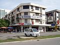 Sinsuran shophouses
 -
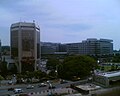 Employees Provident Fund Building


References
- Sabah State Government and DANCED (Danish Co-operation for Environment and Development): Sabah Integrated Coastal Zone Management (ICZM)
- Department of Statistics Malaysia, Sabah: "Monthly Statistical Bulletin, January 2007: Sabah". ISSN 18231659
Footnotes
- ^ Urban area figure obtained after combining population Kota Kinabalu with Putatan and Donggongon; "Malaysia: metropolitan areas", World Gazetteer. Retrieved on March 6, 2007.
- ^ With a 233% increase in population from 1991 to 2007; "Malaysia: largest cities and towns and statistics of their population", World Gazetteer. Retrieved on April 6, 2007.
- ^ "Mat Salleh Fort", History of Malaysia, Perpustakaan Negara Malaysia. Accessed April 8, 2007.
- ^ Fujio, Hara. "The 1943 Kinabalu Uprising in Sabah", Anti-Japanese Movements in Southeast Asia During World War II, Association for Asian Studies, Inc. USA. Accessed March 4, 2007.
- ^ "Sabah's Heritage: A Brief Introduction to Sabah's History", Muzium Sabah, Kota Kinabalu. 1992
- ^ a b Sorudim, Lesaya. "KINABALU: Kina Balu , Aki Nabalu, or Ki Nabalu?", KDCA Publications. May 2, 2005
- ^ "Dragons of Fame: China", The Circle of Dragon. Accessed April 9, 2007.
- ^ "Kinabalu Dragon", The Dragon Stone. Accessed April 9, 2007.
- ^ "Mount Kinabalu", Virtual Malaysia. Accessed April 2, 2007.
- ^ "History of Sabah", Sabah Travel Guide. Accessed March 8, 2007.
- ^ a b "Original name still a poser", TheStar Online. February 2, 2000.
- ^ Chung, Yoon-Ngan. "The Hakkas in Kota Kinabalu (Api)", Federated Hakka Associations of Malaysia. Retrieved March 4, 2007.
- ^ Sawatan, Jackson. "Adakah Gaya Sekadar 'Singgah mata' Untuk Pembangkang?", BERNAMA. Retrieved March 8, 2007.
- ^ Parliament and State Legislative Assemblies, Election Commission of Malaysia.
- ^ a b "Monthly Statistical Bulletin, January 2007: Sabah", Department of Statistics Malaysia, Sabah.
- ^ Sattelite image of Kota Kinabalu, Google Maps. Accessed March 17, 2007.
- ^ Penampang Distict Council
- ^ "Misi 3K asas kejayaan DBKK", Berita Harian Online. Accessed February 3, 2007
- ^ "Cops storm Pulau Gaya, clash leaves one dead, four injured" TheStar Online. August 5, 2006
- ^ Sadiq, Kamal. "When States Prefer Non-Citizens Over Citizens: Conflict Over Illegal Immigration into Malaysia", International Studies Quarterly (2005) 49, (p.101-122), University of California–Irvine. Retrieved March 13, 2007.
- ^ Mantra, Ida Bagoes (1998). “Indonesian Labor Mobility to Malaysia (A Case Study: East Flores, West Lombok, and The Island of Bawean)”, paper presented at the National Workshop on International Migration at Yogyakarta, 9-11 March 1998, by the Population Studies Center, Gadjah Mada University, Indonesia. Retrieved March 15, 2007.
- ^ Reid, Anthony. "Endangered Identity: Kadazan or Dusun in Sabah", Journal of Southeast Asian Studies, Vol. 28, 1997
- ^ Introduction, Kota Kinabalu Industrial Park. Accessed April 9, 2007.
- ^ The tour, North Borneo Railway. Accessed April 9,2007.
- ^ "KKIA to become key air hub", TheStar Online. February 15, 2007.
- ^ "Sepanggar Container Port Terminal ready", Daily Express News. August 8, 2006
- ^ "SPSB raih pendapatan RM157.9j", Berita Harian Online. Accessed March 7, 2007.
- ^ Roles of SPA, Sabah Ports Authority.
- ^ List of court addresses, Malaysian Court. Accessed April 2, 2007.
- ^ Direktori: Alamat dan telefon PDRM, Polis Diraja Malaysia. Accessed April 2, 2007.
- ^ Senarai hospital kerajaan, Ministry of Health. Accessed April 2, 2007.
- ^ List of member hospital, Association of Private Hospitals of Malaysia. Accessed April 2, 2007.
- ^ Introduction, Sabah State Libarary Online. Accessed April 9, 2007.
- ^ "Sabah's first zoo ready soon", Daily Express News. February 22, 2005.
- ^ a b Reign226's Guide to Kota Kinabalu, Sabah, Malaysia Students. June 06, 2006.
External links
- Reign226's Guide to Kota Kinabalu, Sabah, a guide written by local citizen.
- History of Kota Kinabalu
- Sabah Travel Guide to Kota Kinabalu
- Template:Wikitravel
Capital: Kota Kinabalu | |||||||||||
| Topics | |||||||||||
| Society | |||||||||||
| Administrative divisions |
| ||||||||||
bus lceland