Alpine foothills
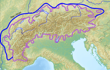
The alpine foothills are the highlands around the Alps .
structure
-
Northern Alpine Foreland : Northern Switzerland and areas of Germany between the Danube (or Swabian Alb , Franconian Alb , Bavarian Forest ) and the Northern Alps
- Swiss plateau , between the Jura and the Alps from Lake Geneva to Lake Constance
-
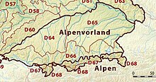
German natural area Alpine foothills
- Main unit group (D64) Donau-Iller-Lech-Platte
- Natural area main unit group (D65) Lower Bavarian hill country and Isar-Inn gravel slabs
- Natural area main unit group (D66) Bavarian Alpine Foreland
-
Austrian Alpine foothills : mainly Molasse zone in the north of Upper and Lower Austria
- Salzburg Alpine foothills in the northern Flachgau to the Innviertel
- Upper Austrian Alpine Foreland
- Lower Austrian Alpine Foreland
- Eastern and southeastern Alpine foothills between the eastern edge of the Alps and the Pannonian Basin (mainly Marchfeld , Vienna Basin , Styria and eastern Pannonia )
-
French foothills of the Alps
- In the Auvergne-Rhône-Alpes region roughly the areas bounded by the Western Alps , the French Jura , the Beaujolais region and the northern foothills of the Massif Central , including the Rhone and Saône valleys, the northern Dauphiné and the southern Bresse ( Bresse savoyarde )
- In the Provence-Alpes-Côte d'Azur region, all areas between the Mediterranean in the south, the Western Alps in the east and the Massif Central in the east
- Southern Alpine Foreland , also Italian Alpine Foreland , between the Alps and the Po Valley
Disambiguation, geology
In geomorphology, the Alpine Foreland refers to the regions around the Alps in which the basement (granite, gneiss) and rocks from the Jurassic and Triassic periods are largely detached or covered by sediments from the Tertiary and Quaternary periods , which are later covered in the southern part in turn were influenced by changes in the Ice Age. In contrast, the foothills of the Alps are also in a regional geographic context.
Northern Alpine Foreland
- About 150 million years ago (Jurassic-Cretaceous border) the forerunners of the Alps slowly emerged, as the African continental plate began to move towards the European continental plate after the Pangea broke up. The ocean between the continental plates (an offshoot of the Thetys) was largely pushed under the African continental plate by subduction. When the African and European continental plates collided, the African plate began to slide onto the European one. Due to the enormous pressure, the rock layers that we now call the Alps were folded. Most of the alpine mountain formation took place around 50 - 2.6 million years ago. The trough ( molasse basin ) formed by the displacement today forms the area of the Northern Alpine Foreland. With the formation of the Alps, their erosion by wind and water (rock cycle) began at the same time . During the tertiary period (approx. 66–2.5 million years ago), up to 5000 meters thick sediments of silt and clay (“ Tegel ”, “ Schlier ”), sand and rubble were deposited in the Molasse basin as a result of erosion . The trough was, so to speak, filled up by the erosion of the Alps. The landscape at that time was subject to major changes due to alternating phases of flooding and siltation. Since the region was even closer to the equator in the tertiary period, tropical and subtropical forests repeatedly formed in the silted up parts of the basin around 30 million years ago. The later overlaying of this lush vegetation with sea water and eroded sediments as well as the further thrust of the African continental plate over the European one exerted high pressure on the plant remains, which ultimately led to their charring. The deposits of pitch coal that were mined in Peißenberg and Penzberg in the 19th and 20th centuries come from this time.
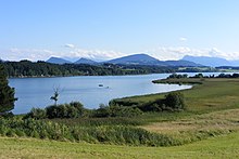
- While in a strip that stretches from Dachau to Ingolstadt, the molasse rocks deposited in the Tertiary still form the direct subsurface today, the southern part of the northern foothills of the Alps owes its current shape in particular to the Ice Ages , which began about 2.6 million years ago and the Mark the beginning of the Quaternary. During the ice ages, glaciers repeatedly made their way from the central Alps (for example the Ötztal) through the northern and southern parts of the Alps to far into the Alpine foothills. In doing so, they planed the valleys that had been shaped by rivers into wide trough valleys ( Inntal , Isartal, Loisachtal, Ammertal, Lechtal). Even in the mountain areas that were not shaped by rivers, they left clear traces, for example between Jochberg and Herzogstand from where the main tongue of the Isar-Loisach glacier met the Alpine foothills. Depending on the strength and resilience, the subsoil of the Alpine foothills was excavated by the glaciers to different depths. These excavations can still be traced very well today using topographical maps and relief maps and show the advances of the glacier tongues (especially during the Würm glacial period ). The basins of the foothills of the Alps that were excavated in this way have since been filled with both water and debris by the rivers that flow into them and transport debris from the Alps. The areas that have not yet silted up form some lakes in the foothills of the Alps ( Ammersee , Starnberger See , Staffelsee , Chiemsee , Wörthsee , Tegernsee , Pilsensee ), while the relatively freshly filled with lake clay (and thus largely water-retaining) areas form the moorlands of the foothills of the Alps (including the Murnauer Moos and Weilheimer Moos). Since the Starnberger See has hardly any tributaries, it silts up very slowly and is therefore significantly deeper at 128 m than the other lakes in the foothills of the Alps. Deadsee lakes such as the Osterseen near Iffeldorf, on the other hand, were not primarily formed by excavation, but rather by large blocks of ice that melted from the main tongue of the glacier and are now partially fed by groundwater. While the Ice Age glaciers carved out parts of the foreland to form lake areas, so-called moraine walls formed on the edges of the glaciers . These arise because the glacier pushes the eroded rock and earth material in front of it (terminal moraine ) and deposits it on the sides ( side moraine ). If the supply of glaciers and the melting of the glacier are balanced, piles of rubble accumulate at the glacier edges due to wind and meltwater sand. So-called ground moraines can also be deposited below the glacier through streams and cavities running through the glacier . The terminal, lateral and ground moraines of the glaciers are the cause of a large part of the hills in the Alpine foothills. Depending on the conditions, special moraine formations develop, for example in the Eberfinger Drumlinfeld , where the teardrop-shaped elongated hills indicate the main thrust of the glacier tongues.
- The glaciers reached their greatest expansion around 460,000–400,000 years ago ( Mindel glacial period ) and 150,000 years ago ( Riss glacial period ). At that time, the glacier tongues almost reached as far as Munich. However, the glacier advances of the last glacial period, which lasted from around 115,000 - 15,000 years ago ( Würm glacial period ), are particularly responsible for the current shape of the landscape of the northern Alpine foothills . Each cold period is followed by a warm period in which the glaciers retreat again. When the several hundred meters thick glaciers melted, large amounts of melt water and gravel carried along by the glacier were released, which then - mostly following the course of the river - flowed off towards the north. The gravel masses were deposited accordingly to the north of the glacier areas and thus created the extensive Munich gravel plain, which borders the molasse layers from the Tertiary to the north. Over the millennia, the rivers dug their way deeper and deeper into the gravel layers and even into the molasse layers, creating characteristic terraces such as those in Apfeldorf . To the north of the molasse layers, the Swabian and Franconian Jura are essentially the rock layers from the Jura and Cretaceous periods that are not included in the molasse trough.
- In the warm periods, plants and animals were able to colonize the habitats released by the glacier. Due to the great differences in soils ( moors , floodplains , lime-poor / lime-rich soils, etc.) there is an extraordinary variety of different - even rare - plant and animal species in the northern foothills of the Alps. These in turn had an influence on the geology and, for example, contributed to the formation of the characteristic limestone tuffs , which are important for the cultural development of the region , through the carbon dioxide produced during metabolism .
- Lignite, crude oil and natural gas are found in natural resources. In contrast to the foreland molasses, the southern edge is heavily influenced by the thrusts of the Alps ( subalpine molasses ). The previously deposited molasses debris was unfolded and solidified by later thrusts. These thrusts resulted in the formation of hills and smaller mountains which, due to their strength, could not be eroded by the later advancing glaciers. Among them are the Peißenberg, Berg bei Huglfing, Auerberg bei Bernbeuren, Tischberg, Taubenberg and Irschenberg.
- The eastern and south-eastern , Italian and French foothills of the Alps are strongly embossed edges of the alpine ceiling system.
Historical meaning
Historically , the foothills of the Alps is a region of particular interest, as cities were founded and developed well at the outflows of rivers from the Alps due to the favorable location on transport routes (river valleys), good flat soils and easily defendable peripheral mountains, examples are Salzburg , Graz , Gorizia , Verona and Milan .
morphology
| Lake and moraine land | Gravel plains | Tertiary hill country |
|---|---|---|
| Origin: | ||
|
Glaciation areas surrounding the mountainous region in a garland shape:
|
Melting of the ice masses in the interglacial periods :
|
Raising of coarse and fine solidified sediments in the Tertiary
|
| Relief : | ||
|
|
|
| Floor : | ||
|
|
|
| Use: | ||
|
|
|
Classification
Northern Alpine Foreland
The most important in terms of dimensions is the northern foothills of the Alps, which stretches in a wide arc, narrowing towards the east, from the southern Black Forest via Württemberg and Bavaria to Austria. In the terminal moraine landscapes in the southern part of the northern foothills of the Alps there are many lakes, some of which protrude into the mountains ( Lake Constance , Tegernsee , Starnberger See , Chiemsee , Attersee , Mondsee , Traunsee etc.). The northern foothills of the Alps is characterized by partly flat, partly hilly meadow landscapes and forest areas. The alpine and pre-alpine elevations form the southern border; It should be noted that some larger elevations are located far to the north in the flatter area, such as the Auerberg (Allgäu) the Hohe Peißenberg and the Taubenberg in Bavaria as well as the Haunsberg in Salzburg's Flachgau, which, however, geologically already belongs to the Flysch zone and thus to the Pre-Alps would be expected. In the north-west, the landscape is bounded by the Swabian Alb , later by the Danube , which separates the Alpine foothills from the mountain ranges of Franconia, eastern Bavaria and Austria (including the granite and gneiss highlands ) to the north . In the east, the northern foothills of the Alps, which has now become a narrow strip, ends at the gates of the Tullnerfeld .
The following countries and regions have a share in the northern foothills of the Alps: Baden-Württemberg ( Upper Swabia , Lake Constance ), Bavaria ( Swabia , Allgäu , Upper and Lower Bavaria south of the Danube), Salzburg ( Flachgau ), Upper Austria (central country, Inn , Traun and Hausruck districts ), Lower Austria (especially the Mostviertel ).
The landscapes of northern Switzerland between the Alps and the Jura - the Central Plateau - can also be assigned to this region, although they are not referred to as the “Alpine foothills” there. The higher areas in the north between the Central Plateau and the Alps in the south between the Alps and the Po Valley are known as the pre-Alps in Switzerland .
French foothills of the Alps
The Alpine foothills of France are located in the two regions of Auvergne-Rhône-Alpes and Provence-Alpes-Côte d'Azur . It begins on the Swiss border near Geneva as a continuation of the Swiss plateau and extends along the Rhone Valley between the Savoy Alps and the French Jura to the metropolitan region of Lyon . Strictly speaking, the Bresse savoyarde to the north of it and the areas around the southern course of the Saône can also be counted here, which is bordered by the Beaujolais region in the east . In this part of the French foothills of the Alps shows almost exactly the same landscape characteristics as the northern foothills of the Alps described in the previous paragraph. To the south of Lyon, the areas between the French Limestone Alps in the east and the Massif Central in the west belong to the French Alpine foothills, including the northern Dauphiné , the Vercors and Chartreuse foothills , the Côtes du Rhône , the Provençal Prealps and the Massif des Maures , the geologically no longer belongs to the Alps.
Alpine foothills in the east and southeast
On the eastern edge of the Alps, from the Leithagebirge , the Alpine foothills include the edge of the Kleiner Puszta and the hilly regions of southern Burgenland and Lower Styria , as well as the eastern Styrian hill country on both sides of the border, ending at the Krainer Karst . There are remains of volcanic phenomena with many thermal baths that are used for tourism.
Southern foothills of the Alps
The southern foothills of the Alps lies almost entirely in Italy , the eastern edge extends to Slovenia . As regions, it includes the domes on the edge of the Southern Limestone Alps or the Po Valley and their extension in the east on the lower reaches of the Etsch , Brenta , Piave , Tagliamento and Isonzo, as well as the hilly landscapes of Lombardy and Piedmont .
Web links
- Entry on Alpine foreland in the Austria Forum (in the AEIOU Austria Lexicon )
Individual evidence
- ^ Rothe, Peter . : Geological history: Searching for traces in the rock . 2nd, updated and exp. WBG, Darmstadt 2009, ISBN 3-534-22257-1 .
- ↑ Meyer, Rolf KF, Schmidt-Kaler, Hermann .: Walks in the history of the earth. (8), On the trail of the Ice Age south of Munich: eastern part . Pfeil, Munich 1997, ISBN 3-931516-09-1 .
- ↑ Meyer, Rolf KF, Schmidt-Kaler, Hermann .: Walks in the history of the earth. (8), On the trail of the Ice Age south of Munich: eastern part . Pfeil, Munich 1997, ISBN 3-931516-09-1 .
- ↑ Reinhold Lehmann, Kathrin Schön: GeoWandern Münchner Umland - Alpine foothills and Alps between Lech and Inn . Bergverlag Rother, Oberhaching 2017, ISBN 978-3-7633-3156-7 .
- ↑ Meyer, Rolf KF, Schmidt-Kaler, Hermann .: Walks in the history of the earth. (8), On the trail of the Ice Age south of Munich: eastern part . Pfeil, Munich 1997, ISBN 3-931516-09-1 .


