
Lam
| coat of arms | Germany map | |
|---|---|---|

|
Coordinates: 49 ° 12 ' N , 13 ° 3' E |
|
| Basic data | ||
| State : | Bavaria | |
| Administrative region : | Upper Palatinate | |
| County : | Cham | |
| Height : | 622 m above sea level NHN | |
| Area : | 33.39 km 2 | |
| Residents: | 2650 (Dec. 31, 2019) | |
| Population density : | 79 inhabitants per km 2 | |
| Postal code : | 93462 | |
| Area code : | 09943 | |
| License plate : | CHA, KÖZ, ROD , WÜM | |
| Community key : | 09 3 72 138 | |
| LOCODE : | DE ZAE | |
| Market structure: | 28 districts | |
Market administration address : |
Schulweg 4 93462 Lam |
|
| Website : | ||
| Mayor : | Paul Roßberger jun. (CSU / BWV) | |
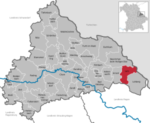
| Location of the Lam market in the Cham district | ||
  |
||

Lam is a market in the Upper Palatinate district of Cham in Bavaria .
geography
Geographical location
The market Lam is close to the Czech border in the Bavarian Forest in the narrow valley of the Lamer Winkel together with the communities Arrach and Lohberg . The valley is bordered by the mountains Arber , Osser , Kaitersberg and Hoher Bogen . The White Rain , which rises from the Kleiner Arbersee at the foot of the Großer Arber, flows through the Lamer Winkel .

Community structure
Lam has 28 districts:
In the Lam market there are the districts of Lam and Engelshütt.
Neighboring communities
- Lohberg
- Arrach
- Neukirchen b. Holy Blood
- Arnbruck , Regen district
history

From its founding in the 13th century to the 21st century
The place was first mentioned on May 29, 1279 in a document from Bishop Heinrich von Regensburg . The first settlers to reclaim the primeval forest at the foot of the Osser came from St. Ulrich am Pillersee in Tyrol. These had been given the land between Osser, Arber and Zwercheck from the Rott am Inn monastery as a new fracture tenth. Until 1679 the monastery exercised the basic rule .
See also: Burgstall Großer Osser
From 1463 on, silver and later copper ore mining began in the immediate vicinity of Lam. In 1522, Duke Wilhelm IV. Elevated Lam as well as Bodenmais to a free mountain town . In 1732 the mine was closed due to technical difficulties. In 1961, Lam became administratively a market.
Since January 12, 1998 the Fürstenzeche has been operated as a visitor mine as well as a healing and therapy gallery.
Incorporations
On January 1, 1978, the previously independent municipality of Engelshütt was incorporated into the Lam market.
Population development
Between 1988 and 2018, the population fell from 3,095 to 2,599 by 496 inhabitants or 16% - the highest percentage loss in the district in the period mentioned.
politics
City council and mayor
The market council has 14 members and a full-time mayor . The municipal council election on March 15, 2020 had the following result:
| Seats | Share of votes | |
|---|---|---|
| CSU - civil voters' association | 5 | 33.3% |
| FREE VOTERS - Free Voters Lam | 1 | 9.5% |
| Independent women's movement Lam | 4th | 25.8% |
| Free voters - Lam has a future | 2 | 15.7% |
| Free voters - surrounding area | 2 | 15.7% |
| total | 14th | 100.0% |
The turnout was 69.4%.
The first mayor is Paul Roßberger jun. (CSU / Civic Voters' Association). He was elected in the 2014 local elections with 55.6% of the valid votes and was confirmed for a further six years on March 15, 2020 with 72.6% of the valid votes.
coat of arms
Blazon : In red on a green three-hill covered with a silver wavy beam, a two-tower church in front view; behind it, a golden spade and a golden mallet crossed at an angle.
The church symbolizes the Benedictine monastery Rott am Inn , which formerly exercised the manorial rule, the spade stands for the clearing in the 13th century and the mallet for the former silver ore mining.
Culture and sights

Buildings
- The Catholic parish church of St. Ulrich was rebuilt by 1765 after the great local fire of 1699, including the Gothic tower. The rich baroque furnishings from around 1750 received additions in the 20th century. In the cemetery wall there are niche graves with statues of saints. At the beginning of the 1990s the church was renovated. a. the two-story organ loft was replaced by a simple one.
- Historic silver and fluorspar mine in Fürstenzeche
- Fairytale and ghost castle in Lambach
- The pilgrimage chapel Maria Hilf above the district of Himmelreich is located on the ridge that leads over the saddle to the Osser. It was built in 1752 and redesigned in the neo-Romanesque style in 1851 . In 1907 it received a stone porch.
Green spaces and recreation
- The Kurpark is somewhat hidden: At the upper end of the market square, turn right through the Kinogasse and past the large car park to get there. It is now part of the new circular hiking trail "The legendary way".
Economy and Infrastructure
Road and rail transport
The main arteries in Lam are the state highways St2138 and St2154.
Lam is the terminus of the railway line from Cham . Diesel multiple units of the type Regio-Shuttle operate , which are operated by the Regentalbahn .
Established businesses
The largest employer is the Simba-Dickie-Group , which manufactures wooden toys under the name HEROS ; in future Heros will be operated under the traditional Eichhorn brand. Zollner Elektronik AG from Zandt offers additional jobs in its Lam plant (Plant 3). The main branch of the economy in the state-recognized climatic health resort of Lam is tourism .
tourism
In addition to several hotels, there are many small pensions and holiday apartments . In addition, in the outlying district of Lambach, there is a Kolping House or a family holiday home , the family hotel Lambach. There is also a campsite in Lam .
Public facilities
- Tourist information
- Osserbad
- Spa gardens
- Parish and community library Lam: The community library Lam is one of the most successful and oldest public libraries in Eastern Bavaria. It has been supported jointly by the Catholic Parish Church Foundation and the market for many years and by the Sankt Michaelsbund , Landesverband Bayern e. V., professionally supervised. In 2005, the library had almost 22,000 loaned books with over 10,000 books and other media. More than 20% of lamers and citizens are regular users who visited their library about 8000 times in 2005. This makes the Lam community library, which is housed in the town hall, the most successful cultural institution in the area.
education
Sports
The SpVgg Lam was founded in 1923. The club currently consists of the football , alpine skiing and Nordic skiing departments . The current membership is around 610.
The first team in the soccer division played in the Landesliga Mitte in 2013 . The home games are played on the local school sports field on Ginglmühler Straße.
Sons and daughters of the place
- Monika Bergmann (* 1978), former ski racer (specialty slalom )
- Joseph Berlinger (* 1952), playwright, theater director, dialect lyric poet, writer, radio play author and screenwriter
- Michael Koller (1809–1861), doctor and member of the state parliament in the Kingdom of Bavaria
- Gabriele Krone-Schmalz (* 1949), historian, television journalist and author
- Robert Ulich (1890–1977), pedagogical historian and philosopher
Web links
- Official website of the municipality
- Tourism site Lamer Winkel
- Entry on Lam's coat of arms in the database of the House of Bavarian History
Individual evidence
- ↑ "Data 2" sheet, Statistical Report A1200C 202041 Population of the municipalities, districts and administrative districts 1st quarter 2020 (population based on the 2011 census) ( help ).
- ^ Bayerische Landesbibliothek Online (BLO) with details on the local breakdown
- ^ Federal Statistical Office (ed.): Historical municipality directory for the Federal Republic of Germany. Name, border and key number changes in municipalities, counties and administrative districts from May 27, 1970 to December 31, 1982 . W. Kohlhammer GmbH, Stuttgart / Mainz 1983, ISBN 3-17-003263-1 , p. 643 .
- ↑ 2020 municipal council election , accessed on August 15, 2020
- ↑ Mayoral election 2020 , accessed on August 15, 2020
- ^ Entry on Lam's coat of arms in the database of the House of Bavarian History

Arnschwang | Arrach | Bad Kötzting | Blaibach | Cham | Chamerau | Eschlkam | Falkenstein | Furth in the forest | Gleißenberg | Grafenwiesen | Hohenwarth | Lam | Lohberg | Michelsneukirchen | Miltach | Neukirchen near the Holy Blood | Pemfling | Pösing | Reichenbach | Rettenbach | Rimbach | Roding | Rötz | Rounding | Schönthal | Schorndorf | Stamsried | Tiefenbach | Traitsching | Treffelstein | Weapon Well | Forest | Walderbach | Waldmünchen | Weiding | Willmering | Zandt | Cell