Artigues (Aude)
| Artigues | ||
|---|---|---|

|
|
|
| region | Occitania | |
| Department | Aude | |
| Arrondissement | Limoux | |
| Canton | La Haute-Vallée de l'Aude | |
| Community association | Pyrénées Audoises | |
| Coordinates | 42 ° 48 ' N , 2 ° 13' E | |
| height | 434-1,204 m | |
| surface | 6.38 km 2 | |
| Residents | 73 (January 1, 2017) | |
| Population density | 11 inhabitants / km 2 | |
| Post Code | 11140 | |
| INSEE code | 11017 | |
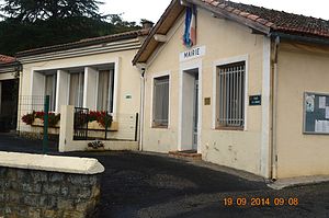
 Mairie Artigues |
||
Artigues is a commune in the French administrative region of Occitania , in the Aude department , in the Limoux arrondissement and in the canton of La Haute-Vallée de l'Aude . Neighboring municipalities are Cailla in the north, Axat in the east, Sainte-Colombe-sur-Guette in the southeast, Roquefort-de-Sault in the south and Le Clat in the west. The inhabitants call themselves the Artigois. The Col du Garabeil is a 1262 m high elevation near Artigois.
Population development
| year | 1962 | 1968 | 1975 | 1982 | 1990 | 1999 | 2008 | 2015 |
|---|---|---|---|---|---|---|---|---|
| Residents | 92 | 102 | 95 | 94 | 83 | 82 | 86 | 75 |
Attractions
- Saint-Nicolas church, from 1830
Web links
Commons : Artigues - collection of images, videos and audio files
