
Clermont-sur-Lauquet
|
Clermont-sur-Lauquet Clarmont |
||
|---|---|---|
.svg)
|
|
|
| region | Occitania | |
| Department | Aude | |
| Arrondissement | Limoux | |
| Canton | La Région Limouxine | |
| Community association | Limouxin | |
| Coordinates | 43 ° 3 ' N , 2 ° 25' E | |
| height | 338-705 m | |
| surface | 18.29 km 2 | |
| Residents | 26 (January 1, 2017) | |
| Population density | 1 inhabitant / km 2 | |
| Post Code | 11250 | |
| INSEE code | 11094 | |
 Town hall (Mairie) of Clermont-sur-Lauquet |
||

Clermont-sur-Lauquet ( Occitan : Clarmont ) is a municipality with 26 inhabitants (as of January 1, 2017) in the French department of Aude in Occitania . It belongs to the canton of La Region Limouxine (until 2015: canton of Saint-Hilaire ) in the arrondissement of Limoux . The inhabitants are called Clermontains .
geography
Clermont-sur-Lauquet is located about 20 kilometers south-southeast of Carcassonne on the Lauquet . Clermont-sur-Lauquet is surrounded by the neighboring communities of Greffeil in the north and north-west, Villar-en-Val in the north, Labastide-en-Val in the east and north-east, Lairière in the south-east, Caunette-sur-Lauquet in the south and Saint-Hilaire in the West and northwest.
Population development
| year | 1962 | 1968 | 1975 | 1982 | 1990 | 1999 | 2006 | 2013 |
|---|---|---|---|---|---|---|---|---|
| Residents | 28 | 26th | 27 | 29 | 22nd | 26th | 23 | 27 |
| Source: Cassini and INSEE | ||||||||
Attractions
- Saint-Loup church from the 11th century, monument historique
- Donjon as the rest of the castle from 1110

Saint-Loup church
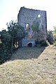
Donjon


Web links
Commons : Clermont-sur-Lauquet - Collection of images, videos and audio files