
Kremsmünster
|
market community Kremsmünster
|
||
|---|---|---|
| coat of arms | Austria map | |
 |
|
|
| Basic data | ||
| Country: | Austria | |
| State : | Upper Austria | |
| Political District : | Church Village | |
| License plate : | AI | |
| Surface: | 42.14 km² | |
| Coordinates : | 48 ° 3 ' N , 14 ° 8' E | |
| Height : | 384 m above sea level A. | |
| Residents : | 6,697 (January 1, 2020) | |
| Population density : | 159 inhabitants per km² | |
| Postal code : | 4550 | |
| Area code : | 07583 | |
| Community code : | 4 09 07 | |
| NUTS region | AT314 | |
| Address of the municipal administration: |
Rathausplatz 1 4550 Kremsmünster |
|
| Website: | ||
| politics | ||
| Mayor : | Gerhard Obernberger ( ÖVP ) | |
|
Municipal Council : (2015) (31 members) |
||
| Location of Kremsmünster in the Kirchdorf district | ||
  |
||
 South-east view of Kremsmünster with the monastery that dominates the townscape |
||
| Source: Municipal data from Statistics Austria | ||

Kremsmünster is a market town in Upper Austria in the Kirchdorf an der Krems district in the Traunviertel with 6697 inhabitants (as of January 1, 2020). The responsible judicial district is Kirchdorf an der Krems .
The name goes back to the Benedictine monastery Kremsmünster . It was founded in 777 and is the cultural center of the region. His famous observatory is called the Mathematical Tower .
geography
Kremsmünster is located at 384 m above sea level in the Traunviertel, on a striking river terrace of the Krems . The municipality measures 8.9 km from north to south and 9.5 km from west to east. The total area is 42 km². 16.2% of the area is forested and 71.9% is used for agriculture.
The highest point is the Gusterberg, 2 km south , at 488 m . On its top ("tree in the middle of the world") is the former fundamental point of the national survey (1823-1830). At the end of the 19th century, the place gave its name to the Kremsmünster meridian arch , which had its central point in the monastery observatory.
Community structure
The municipality comprised the following localities:
- Au
- Dehenwang
- Dirnberg
- Egendorf
- Grub
- Guntendorf
- Heiligenkreuz
- Helmberg
- Irndorf
- Kirchberg
- Kremsegg
- Kremsmünster
- Krift
- Krühub
- Mairdorf
- Oberburgfried
- Top tube (partially)
- Pochendorf
- Regau
- Schürzendorf
- Lower keep
- Wolfgangstein
Neighboring communities
.svg)
climate
|
Average monthly temperatures and precipitation for Kremsmünster
|
|||||||||||||||||||||||||||||||||||||||||||||||||||||||||||||||||||||||||||||||||||||||||||||||||||||||||||||||||||||||||||||||||||||||||||||||||||||||||||||||||||||||||
history
The Benedictine monastery Kremsmünster was founded in 777 by the Bavarian Duke Tassilo III. founded. The village of Kremsmünster was first mentioned in a document in 1299. In 1489, Emperor Friedrich III. the village to the market. The Stiftsgymnasium received public rights in 1549 and is one of the most traditional educational institutions in Austria. The Kremsmünster Monastery observatory was built between 1748 and 1759. The building - the Mathematical Tower - is considered the first skyscraper in Europe.
Gusterberg (488 m), two kilometers south of the monastery, was chosen in 1817 as the fundamental point (origin of coordinates) for the Upper Austrian and Bohemian land surveying . Next to it stood the tree in the middle of the world (replanted in 1916), from which you can see almost 100 km in all directions. A lookout tower was built nearby around 2005 .
In 1910 the first power station was built in Kremsmünster.
Population development
In 1991 the community had 5,963 inhabitants according to the census; 2001 then 6,450 inhabitants, of which 811 foreigners (12.6%). The increase corresponds to a plus of 7.9% compared to 1991 with approx. 200 secondary residences. Up until 2011 there was only a slight increase to 5,458 people, as the negative birth balance almost canceled out the positive migration balance . By 2018 the community had grown again to 6,585 residents.
Culture and sights
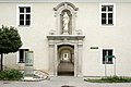
- Kremsmünster Abbey : The Benedictine Abbey was founded in 777 by Duke Tassilo III of Bavaria . Founded by the Agilolfinger family and has existed continuously for over 1200 years (apart from the repeal by the Nazi regime from 1940 to 1945). The monastery owns valuable collections, such as the picture gallery and the chamber of art and curiosities with the famous Tassilo chalice . The monastery runs the Kremsmünster Abbey High School , which has existed since 1549.
- Gunther's grave in the collegiate church: The Gunther's grave, a cenotaph from white Nagelfluh , is crowned by a cover plate with the figure of the dead Gunther and is located in the bell house of the collegiate church. The cover plate dates from before 1304 and represents Gunther, the legendary son of the Bavarian Duke Tassilo III. who, according to the founding legend of the Kremsmünsterer Stift, was fatally wounded by a wild boar while hunting in the forests on the Krems. The boar, with a lance in his body, and the hunting dog Gunthers, who is said to have tracked him down, rest at the feet of Gunther, who is resting on a pillow and wrapped in Romanesque tubular garb. The strong color scheme, which is well preserved, is particularly noteworthy.
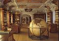
- Kremsmünster Abbey Library : With a length of 65 m and approx. 160,000 volumes, including numerous manuscripts and incunabula , the library is one of the largest libraries in Austria.
- Kremsmünster observatory : built from 1749 to 1758; the observatory, also known as the 'Mathematical Tower', is the first high-rise in Europe. It houses the oldest fixed weather station in Europe. The astronomer Placidus Fixlmillner worked here .
- Fischkalter: five magnificent water basins with fish farms - surrounded by colonnades, built by Carlo Antonio Carlone (1692) and Jakob Prandtauer (1717), form their own courtyards in the monastery.

The pen from the south

Kremsmünster Abbey from Kirchberg

Pen with observatory from the southeast

Gunther's grave in the southern bell house

Tassilo chalice
Riedergang

The founder and the rulers of his time
Pen library

Codex Cremifanensis 243

Fish cold


- Filialkirche Kirchberg: early Rococo building from 1753/54, one of the most beautiful Rococo churches in the country
- Kalvarienberg (Kremsmünster) - Kalvarienbergkirche: baroque, built 1736–1738 by Johann Michael Prunner , altar painting by Bartolomeo Altomonte
- Heiligenkreuz pilgrimage church : built 1687–1690 by Carlo Antonio Carlone
- Kremsegg Castle : Museum of musical instruments
- Town houses: especially in Herrengasse
- Market judge house
- Theater am Tötenhengst is home to Austria's oldest active amateur stage
- Schachenteiche: The Schachenteiche (colloquially called Schachaiche) are located 3 km north of Kremsmünster in the Schachenwald. They were created in 1555 to drain the swampy area. The area around the Schachenteiche is now a valuable bird sanctuary.
- Sunnegg residential tower

Sankt Stefan am Kirchberg

Portal to the cemetery and church

Kirchberg grave complex

Calvary Church

Pilgrimage church Heiligenkreuz

Lattice grille in Heiligenkreuz

Herrengasse 2 window

Herrengasse 11

Market judge's house at Herrengasse 9

The blue house

The killing stallion

Theater on the killing stallion
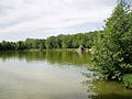
Big chess pond


Economy and Infrastructure
The Greiner Holding has its registered office and production facilities (v. A. Plastics) in Kremsmünster. It has over 10,000 employees worldwide and an annual turnover of over 1,500 million euros. Kremsmünster is also the headquarters of the Eurofoam group .
In 1993 the international packaging glass manufacturer Vetropack takes over the Lutzky Glas glassworks . Three melting tanks of different glass colors enable a daily production of 670 tons. On August 13, 2016, after a power failure, the fire brigade took over the emergency cooling of the 1,400 ° C hot melt pools.
traffic
- Train: Kremsmünster is on the Pyhrnbahn from Linz to Selzthal (with a connection to Graz ). Regional trains and regional express trains stop in Kremsmünster . The journey to Linz usually takes between 30 and 40 minutes, to Selzthal between 1:10 and 1:30 hours. Kremsmünster also serves as a transfer point from public transport bus or car (20 km) from Wels to the Pyhrnbahn in the south, i.e. Selzthal and on to Graz.
- Road: Kremsmünster is on Voralpen Straße (B122) and Kremstal Straße (B139) as well as near Pyhrnpass Straße (B138). The closest motorways are the West Autobahn A1, the Pyhrn Autobahn A9 and the Innkreis Autobahn A8; the next junction, the Voralpenkreuz junction in Sattledt , is about 7 kilometers from the center of Kremsmünster. The Kremstal is a cycle route with little incline from Linz via Kremsmünster to Kirchdorf an der Krems and, thanks to the completion of the A9, it is also relatively car-free via the Pyhrnpass ascent to Liezen im Ennstal .
politics
The municipal council has 31 members (17 ÖVP, 7 SPÖ, 7 FPÖ).
mayor
- until 2009 Franz Fellinger (ÖVP)
- since 2009 Gerhard Obernberger (ÖVP)
coat of arms
Blazon: In green a black, red armored, jumping boar with silver tusks and fangs, pierced by a golden, kinked hunting spear in a red, bleeding wound.
The motif refers to the founding legend of the monastery, which reports that Duke Tassilo III. von Baiern had the monastery built on the Krems as a memorial site at the point where his son Gunther, who was bleeding to death under the tusks of an angry boar wounded with a hunting spear, was found dead.
Personalities
Sons and daughters of the church
- Bernhard von Rohr (1421–1487), Archbishop of Salzburg 1466–1482
- Ignaz Rudolf Bischoff (1784–1850), doctor
- Leonard Achleuthner (1826–1905), clergyman and politician
- Leonhard Angerer (1861–1934), clergyman, teacher and natural scientist
- Roland Weitzenböck (1885–1955), mathematician
- Josefine Hawelka (1913–2005), coffee house legend
- Heinz Pollak (1913–1974), film production and line producer
- Oddo Bergmair (1931–2020), Benedictine abbot
- August Mandorfer (* 1933), clergyman
- Anita Baierl (* 1988), middle and long distance runner
Personalities associated with the community
- Johannes Brik (1899–1982), clergyman
- Placidus Fixlmillner (1721–1791), versatile scientist, university professor and astronomer of the late Baroque 1762–1791, director of the Kremsmünster observatory
- Gotthard Hofstädter (1826–1864), clergyman and natural scientist
- Gunter Janda (1933–2015), clergyman and adult educator
- Tina Kofler (1872–1935), graphic artist and painter
- Benedikt Lechler (1594–1659), clergyman, composer, music teacher
- Beda Plank (1741–1830), clergyman, playwright and choirmaster
- Heinz Preiss (* 1942), music teacher and politician
- Simon Rettenpacher (also Rettenbacher, 1634–1706), baroque poet, university professor, collegiate librarian
- Norbert Maria Schachinger (1897–1974), clergyman and founder of the order
- Pankraz Stollenmayer (1889–1980), clergyman, teacher and historical researcher
- Simon Wascher (* 1966), musician and dancer
- Mario Zippermayr (1899–1979), physicist and National Socialist
- Philipp Zippermayr (* 1949), homeopath and comic author
literature
- Market community Kremsmünster (Ed.): Market Kremsmünster 1489–1989. Kremsmünster 1989.
Web links
- Entry on Kremsmünster in the Austria Forum (in the AEIOU Austria Lexicon )
- Further information about the municipality of Kremsmünster on the geo-information system of the federal state of Upper Austria .
Individual evidence
- ^ Statistics Austria, A look at the municipality of Kremsmünster, population development. Retrieved March 23, 2019 .
- ↑ Volker Witt: 250 years of the Kremsmünster observatory. In: Stars and Space 6/2008, pp. 80–85
- ↑ Vetropack Group> History of Vetropack - 1911 ... today Vetropack Holding AG website, © 2007, accessed August 14, 2016.
- ↑ Large-scale fire service due to liquid glass orf.at, August 14, 2016, accessed August 14, 2016.
- ^ Province of Upper Austria, coat of arms of the municipality of Kremsmünster. Retrieved March 23, 2019 .

Edlbach | Grünburg | Hinterstoder | Inzersdorf im Kremstal | Kirchdorf an der Krems | Klaus at the Pyhrnbahn | Kremsmünster | Micheldorf in Upper Austria | Molln | Nussbach | Oberschlierbach | Pettenbach | Ried im Traunkreis | Rosenau am Hengstpaß | Roßleithen | St. Pankraz | Schlierbach | Spital am Pyhrn | Steinbach am Ziehberg | Steinbach an der Steyr | Vorderstoder | Wartberg an der Krems | Windischgarsten